TopoQuest Logo
Do you find TopoQuest useful?
Help keep TopoQuest running and adding new maps/features by donating!
Bitcoin:  19c7KJd3qBynnjoSw5npx9KScwjBe4ifkT
Litecoin:  LXs6TkuXGGXo1vDsWCkWVdjQX94eUKd6ui
Home View Maps Find Maps Find Places Resources & Links


Gadsden, South Carolina Topographic Map

USGS Map Title: Gadsden, SC
USGS Map MRC: 33080G7
DRG (GeoTIFF) Download: o33080g7.tif


Neighboring USGS Topographic Map Quads:


  Fort Jackson South, SC  
33080H8
 

  Congaree, SC  
33080H7
 

  Eastover, SC  
33080H6
 

  Saylors Lake, SC  
33080G8
 

  Gadsden, SC  
33080G7
 

  Wateree, SC  
33080G6
 

  Staley Crossroads, SC  
33080F8
 

  Saint Matthews, SC  
33080F7
 

  Fort Motte, SC  
33080F6


Map MRC Location:

N34°
W81°
N34°
W80°
H8 H7 H6 H5 H4 H3 H2 H1
G8 G7 G6 G5 G4 G3 G2 G1
F8 F7 F6 F5 F4 F3 F2 F1
E8 E7 E6 E5 E4 E3 E2 E1
D8 D7 D6 D5 D4 D3 D2 D1
C8 C7 C6 C5 C4 C3 C2 C1
B8 B7 B6 B5 B4 B3 B2 B1
A8 A7 A6 A5 A4 A3 A2 A1
N33°
W81°
N33°
W80°

Gadsden, SC USGS 1:24K Topographic Map Preview:
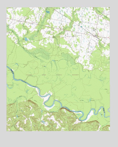
Gadsden, SC USGS Topographic Map
Click on map above to begin viewing in our Map Viewer.

This topographic map contains these locations and features:
Feature Name Type Latitude Longitude GNIS ID View Map
Bannisters BridgeBridgeN33.8407°W80.8598°1248916View Map
Big Beaver CreekStreamN33.7874°W80.8359°1246868View Map
Big LakeSwampN33.7813°W80.7834°1220719View Map
Big Lake Cattle MountSummitN33.7821°W80.7848°1248945View Map
Braddy LakeLakeN33.7692°W80.8192°1220926View Map
Brady PondReservoirN33.7701°W80.8321°1239575View Map
Brady Pond Dam D-2624DamN33.7702°W80.8315°1239574View Map
Bradys Cattle MountSummitN33.7893°W80.8245°1248962View Map
Butlers GutGutN33.7727°W80.8312°1221169View Map
Buyck BottomValleyN33.7590°W80.8347°1221170View Map
Buycks PondReservoirN33.7516°W80.7959°1221171View Map
Cedar Creek Hunt ClubLocaleN33.8163°W80.8268°1248992View Map
Clarkson PondReservoirN33.8704°W80.8247°1221615View Map
Clarkson Pond D-0599 DamDamN33.8702°W80.8265°1237585View Map
Clayton School (historical)SchoolN33.8610°W80.8606°1249008View Map
Columbia - Richland Fire Department GadsdenBuildingN33.8641°W80.7654°2578172View Map
Congaree National Park WildernessReserveN33.7987°W80.7878°1230620View Map
Congaree Spring BranchStreamN33.7821°W80.8631°1221713View Map
Cooners Cattle MountSummitN33.7985°W80.7856°1249029View Map
Damascus Number 2 ChurchChurchN33.8607°W80.8601°1221920View Map
Dry BranchStreamN33.8213°W80.8168°1222105View Map
Duffies PondReservoirN33.8429°W80.8511°1222136View Map
Duffies Pond D-0600 DamDamN33.8440°W80.8526°1237588View Map
GadsdenPopulated PlaceN33.8457°W80.7659°1249488View Map
Gadsden Census Designated PlaceCensusN33.8480°W80.7663°2629827View Map
Gadsden Post OfficePost OfficeN33.8452°W80.7655°1249106View Map
Gadsden SchoolSchoolN33.8527°W80.7676°1249489View Map
Geigers PondReservoirN33.7649°W80.8620°1222673View Map
Hildebrand BranchStreamN33.7560°W80.8668°1223179View Map
Hopkins DivisionCivilN33.8558°W80.8551°1938302View Map
Lord LakeLakeN33.7656°W80.7602°1224194View Map
Madison ChurchChurchN33.8571°W80.8723°1224260View Map
Mount Ararat Church (historical)ChurchN33.8674°W80.7631°1249236View Map
Mount Moriah ChurchChurchN33.8449°W80.8181°1224732View Map
Mount Moriah School (historical)SchoolN33.8415°W80.8348°1249238View Map
Mullers Big LakeLakeN33.7966°W80.8739°1224885View Map
Myers CreekStreamN33.8404°W80.8601°1249768View Map
Old Dead RiverLakeN33.7812°W80.7737°1225173View Map
Old Dead River Cattle MountSummitN33.7779°W80.7659°1249261View Map
Red Hill Church (historical)ChurchN33.8602°W80.7529°1249292View Map
Reeves BranchStreamN33.8435°W80.8545°1225826View Map
Saint Marks ChurchChurchN33.8296°W80.7762°1250593View Map
Saint Pauls ChurchChurchN33.8460°W80.7943°1250656View Map
Sikes CreekStreamN33.7502°W80.8179°1226610View Map
Sikes PondReservoirN33.7591°W80.8304°1226611View Map
South Carolina Noname 09009 D-2622 DamDamN33.7660°W80.8626°1238380View Map
South Carolina Noname 09010 D-2623 DamDamN33.7602°W80.8320°1238382View Map
WestonPopulated PlaceN33.8729°W80.8168°1227996View Map
Weston LakeLakeN33.8213°W80.8177°1227505View Map
Wise LakeLakeN33.8151°W80.8282°1227664View Map
Zion Pilgrim ChurchChurchN33.8493°W80.8718°1227766View Map

Note: Coordinates in the location and feature list above are referenced to NAD83 datum.


Copyright (C) 2008-2025 Ryan Niemi / Sunset Dynamics ... All Rights Reserved