TopoQuest Logo
Do you find TopoQuest useful?
Help keep TopoQuest running and adding new maps/features by donating!
Bitcoin:  19c7KJd3qBynnjoSw5npx9KScwjBe4ifkT
Litecoin:  LXs6TkuXGGXo1vDsWCkWVdjQX94eUKd6ui
Home View Maps Find Maps Find Places Resources & Links


Saint Matthews, South Carolina Topographic Map

USGS Map Title: Saint Matthews, SC
USGS Map MRC: 33080F7
DRG (GeoTIFF) Download: o33080f7.tif


Neighboring USGS Topographic Map Quads:


  Saylors Lake, SC  
33080G8
 

  Gadsden, SC  
33080G7
 

  Wateree, SC  
33080G6
 

  Staley Crossroads, SC  
33080F8
 

  Saint Matthews, SC  
33080F7
 

  Fort Motte, SC  
33080F6
 

  Wolfton, SC  
33080E8
 

  Orangeburg North, SC  
33080E7
 

  Cameron, SC  
33080E6


Map MRC Location:

N34°
W81°
N34°
W80°
H8 H7 H6 H5 H4 H3 H2 H1
G8 G7 G6 G5 G4 G3 G2 G1
F8 F7 F6 F5 F4 F3 F2 F1
E8 E7 E6 E5 E4 E3 E2 E1
D8 D7 D6 D5 D4 D3 D2 D1
C8 C7 C6 C5 C4 C3 C2 C1
B8 B7 B6 B5 B4 B3 B2 B1
A8 A7 A6 A5 A4 A3 A2 A1
N33°
W81°
N33°
W80°

Saint Matthews, SC USGS 1:24K Topographic Map Preview:
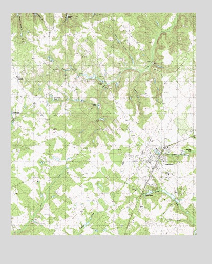
Saint Matthews, SC USGS Topographic Map
Click on map above to begin viewing in our Map Viewer.

This topographic map contains these locations and features:
Feature Name Type Latitude Longitude GNIS ID View Map
Antioch ChurchChurchN33.7160°W80.8651°1220216View Map
Antley SpringSpringN33.6474°W80.7848°1220224View Map
Beckhams PondReservoirN33.6314°W80.8237°1238441View Map
Bell BranchStreamN33.6321°W80.7512°1220472View Map
Belleville Fire DepartmentBuildingN33.7430°W80.8183°2578526View Map
Belleville School (historical)SchoolN33.7393°W80.8309°1245047View Map
Bensons PondReservoirN33.7104°W80.8032°1239567View Map
Bensons Pond Dam D-2626DamN33.7102°W80.8031°1239566View Map
Bobby Gressett PondReservoirN33.6279°W80.8175°1239569View Map
Bobby Gressett Pond Dam D-2662DamN33.6268°W80.8181°1239568View Map
Bozard PondReservoirN33.7465°W80.8340°1220923View Map
Buycls Swamp PondReservoirN33.7120°W80.7777°1239579View Map
Buycls Swamp Pond Dam D-2928DamN33.7135°W80.7781°1239578View Map
Calhoun CountyCivilN33.6749°W80.7803°1247986View Map
Calhoun County CourthouseBuildingN33.6624°W80.7795°1234689View Map
Calhoun County Emergency Medical ServicesBuildingN33.6632°W80.7806°2739544View Map
Calhoun County High SchoolSchoolN33.6654°W80.7990°1234690View Map
Calvary ChurchChurchN33.6988°W80.7734°1221221View Map
Campbell PondReservoirN33.6902°W80.8615°1239585View Map
Campbell Pond Dam D-2678DamN33.6902°W80.8615°1239584View Map
Congaree ChurchChurchN33.7335°W80.8670°1221712View Map
Dicks SwampStreamN33.7188°W80.7909°1222019View Map
Doodle Hill PondReservoirN33.7014°W80.8463°1222065View Map
Furtick PondReservoirN33.7346°W80.8022°1239592View Map
Furtick Pond Dam D-2682DamN33.7335°W80.8031°1239591View Map
Griffith PondReservoirN33.6683°W80.8355°1239598View Map
Griffith Pond Dam D-2679DamN33.6685°W80.8365°1239597View Map
Guinyard Elementary SchoolSchoolN33.6493°W80.7637°1234696View Map
Hammond CrossroadsPopulated PlaceN33.7146°W80.8720°1245892View Map
High Hill CreekStreamN33.7102°W80.8109°1223162View Map
I Prickett PondReservoirN33.7002°W80.8215°1238391View Map
J L Wannamaker PondReservoirN33.7002°W80.7881°1239607View Map
J L Wannamaker Pond Dam D-2685DamN33.7002°W80.7881°1239606View Map
John Ford Middle SchoolSchoolN33.6710°W80.7859°1234701View Map
Lake HelenReservoirN33.7152°W80.8165°1238387View Map
Lake InspirationReservoirN33.6724°W80.7767°1238405View Map
Macedonia ChurchChurchN33.6724°W80.8693°1224246View Map
Mount Carmel ChurchChurchN33.7218°W80.7790°1224700View Map
Mount Olive School (historical)SchoolN33.7465°W80.8095°1234708View Map
Mount Pisgah ChurchChurchN33.6896°W80.8501°1234709View Map
Paradice LakeReservoirN33.6935°W80.8148°1239619View Map
Paradice Lake Dam D-2629DamN33.6935°W80.8148°1239618View Map
Peter Buycls House PondReservoirN33.7199°W80.7744°1239642View Map
Peter Buycls House Pond DamDamN33.7206°W80.7764°1239622View Map
Pilgrim Rest ChurchChurchN33.7077°W80.8101°1225424View Map
Raysors LakeReservoirN33.7012°W80.8306°1248724View Map
Rileys PondReservoirN33.6980°W80.8159°1250389View Map
Rogers Pond (historical)ReservoirN33.6913°W80.8323°1234715View Map
Rowe SchoolSchoolN33.6363°W80.8406°1226056View Map
Saint Mathews Post OfficePost OfficeN33.6665°W80.7768°1252161View Map
Saint MatthewsPopulated PlaceN33.6649°W80.7779°1250621View Map
Saint Matthews DivisionCivilN33.6863°W80.8024°1938407View Map
Saint Matthews Fire DepartmentBuildingN33.6672°W80.7817°2578383View Map
Saint Matthews Police DepartmentBuildingN33.6671°W80.7821°2734233View Map
Saint Matthews Waste Pond Dam D-2638DamN33.6752°W80.7531°1239637View Map
Smith PondReservoirN33.7185°W80.8315°1239633View Map
Smith Pond Dam D-2680DamN33.7185°W80.8315°1239632View Map
Smoke PondReservoirN33.6480°W80.7682°1239635View Map
Smoke Pond Dam D-2929DamN33.6502°W80.7748°1239634View Map
South Carolina Noname 09011 D-2625 DamDamN33.7118°W80.8131°1238384View Map
South Carolina Noname 09012 D-2627 DamDamN33.7152°W80.8165°1238386View Map
South Carolina Noname 09013 D-2628 DamDamN33.6988°W80.8159°1238388View Map
South Carolina Noname 09014 D-2630 DamDamN33.7002°W80.8215°1238390View Map
South Carolina Noname 09015 D-2631 DamDamN33.7002°W80.8298°1238392View Map
South Carolina Noname 09021 D-2635 DamDamN33.6385°W80.7565°1238402View Map
South Carolina Noname 09022 DamDamN33.6735°W80.7765°1238404View Map
South Carolina Noname 09041 D-2661 DamDamN33.6318°W80.8248°1238440View Map
Speigners PondReservoirN33.7120°W80.8135°1238385View Map
Strickland PondReservoirN33.7224°W80.7921°1239623View Map
Strickland Pond DamDamN33.7216°W80.7919°1239641View Map
Sykes PondReservoirN33.6270°W80.7502°1239648View Map
TotnessPopulated PlaceN33.7427°W80.8001°1231869View Map
Town of Saint MatthewsCivilN33.6641°W80.7780°2407272View Map
Union Harbor School (historical)SchoolN33.6896°W80.8509°1251268View Map
Wannamakers PondReservoirN33.6380°W80.7556°1238403View Map
Waste Stabilization PondReservoirN33.6752°W80.7531°1239638View Map
Wertz CrossroadsPopulated PlaceN33.6402°W80.7887°1231904View Map
West End CemeteryCemeteryN33.6621°W80.7895°1227487View Map
WKSO-FM (Orangeburg)TowerN33.6704°W80.8734°1252534View Map

Note: Coordinates in the location and feature list above are referenced to NAD83 datum.


Copyright (C) 2008-2025 Ryan Niemi / Sunset Dynamics ... All Rights Reserved