TopoQuest Logo
Do you find TopoQuest useful?
Help keep TopoQuest running and adding new maps/features by donating!
Bitcoin:  19c7KJd3qBynnjoSw5npx9KScwjBe4ifkT
Litecoin:  LXs6TkuXGGXo1vDsWCkWVdjQX94eUKd6ui
Home View Maps Find Maps Find Places Resources & Links


Gainesville South, Texas Topographic Map

USGS Map Title: Gainesville South, TX
USGS Map MRC: 33097E2
DRG (GeoTIFF) Download: o33097e2.tif


Neighboring USGS Topographic Map Quads:


  Muenster East, TX  
33097F3
 

  Gainesville North, TX  
33097F2
 

  Callisburg, TX  
33097F1
 

  Hood, TX  
33097E3
 

  Gainesville South, TX  
33097E2
 

  Woodbine, TX  
33097E1
 

  Era, TX  
33097D3
 

  Valley View, TX  
33097D2
 

  Mountain Springs, TX  
33097D1


Map MRC Location:

N34°
W98°
N34°
W97°
H8 H7 H6 H5 H4 H3 H2 H1
G8 G7 G6 G5 G4 G3 G2 G1
F8 F7 F6 F5 F4 F3 F2 F1
E8 E7 E6 E5 E4 E3 E2 E1
D8 D7 D6 D5 D4 D3 D2 D1
C8 C7 C6 C5 C4 C3 C2 C1
B8 B7 B6 B5 B4 B3 B2 B1
A8 A7 A6 A5 A4 A3 A2 A1
N33°
W98°
N33°
W97°

Gainesville South, TX USGS 1:24K Topographic Map Preview:
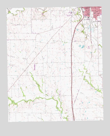
Gainesville South, TX USGS Topographic Map
Click on map above to begin viewing in our Map Viewer.

This topographic map contains these locations and features:
Feature Name Type Latitude Longitude GNIS ID View Map
Alvarado Public LibraryBuildingN33.5782°W97.2125°2015070View Map
Antioch Baptist ChurchChurchN33.6234°W97.1378°2017479View Map
Calvary ChurchChurchN33.6171°W97.1306°1353583View Map
Cloud-Stark HouseBuildingN33.6215°W97.1406°2031376View Map
CookPopulated PlaceN33.6121°W97.1278°1354895View Map
Cooke County Emergency Medical ServiceBuildingN33.6225°W97.1474°2655934View Map
Cooke County Highway PatrolBuildingN33.6241°W97.1464°2738944View Map
Cooke County Junior CollegeSchoolN33.6193°W97.1647°1354905View Map
Dry Elm CreekStreamN33.6215°W97.2467°1356346View Map
Faith Temple ChurchChurchN33.6151°W97.1320°1357202View Map
First Presbyterian ChurchChurchN33.6218°W97.1422°2017445View Map
Freedom FieldAirportN33.5956°W97.2191°1387086View Map
Gainesville Alternative SchoolSchoolN33.6137°W97.1414°2004859View Map
Gainesville Fire Department Station 3BuildingN33.6230°W97.1447°2551748View Map
Gainesville High SchoolSchoolN33.6137°W97.1414°2004860View Map
Gainesville Municipal BuildingBuildingN33.6231°W97.1442°2753690View Map
Gainesville Post OfficePost OfficeN33.6246°W97.1426°2731338View Map
Garden Valley ChurchChurchN33.5351°W97.1261°1357877View Map
J M Lindsay Elementary SchoolSchoolN33.6176°W97.1414°2004862View Map
Leeper StadiumParkN33.6134°W97.1453°1384594View Map
Leonard ParkParkN33.6215°W97.1533°1361102View Map
Leopard StadiumParkN33.6137°W97.1456°2027770View Map
Lindsay Elementary SchoolSchoolN33.6171°W97.1417°2004863View Map
Lindsay SchoolSchoolN33.6171°W97.1417°1361224View Map
McMurray Elementary SchoolSchoolN33.6171°W97.1345°2004865View Map
McMurray SchoolSchoolN33.6173°W97.1339°1362515View Map
Morton Museum of Cooke CountyBuildingN33.6223°W97.1453°2014238View Map
Mount Hope ChurchChurchN33.6193°W97.1328°2017446View Map
Mount Hope ChurchChurchN33.6193°W97.1325°1363258View Map
Sarles LakeReservoirN33.5813°W97.1505°1367783View Map
Sarles Lake DamDamN33.5834°W97.1486°1855294View Map
Soil Conservation Service Site 61q DamDamN33.6201°W97.2003°1855296View Map
Soil Conservation Service Site 61q ReservoirReservoirN33.6201°W97.2003°1855297View Map
Southside Baptist ChurchChurchN33.6112°W97.1317°2017489View Map
Spring Creek ChurchChurchN33.5509°W97.2014°1368995View Map
Stahl AirportAirportN33.5679°W97.1905°2717045View Map
Terrapin HillSummitN33.5498°W97.1289°1369731View Map
Townsend CreekStreamN33.5251°W97.1939°1370060View Map
Valley View CemeteryCemeteryN33.5076°W97.1664°1370561View Map
William and Anna Davis HouseBuildingN33.6196°W97.1428°2032412View Map
Willow CreekStreamN33.5109°W97.1792°1371630View Map

Note: Coordinates in the location and feature list above are referenced to NAD83 datum.


Copyright (C) 2008-2025 Ryan Niemi / Sunset Dynamics ... All Rights Reserved