TopoQuest Logo
Do you find TopoQuest useful?
Help keep TopoQuest running and adding new maps/features by donating!
Bitcoin:  19c7KJd3qBynnjoSw5npx9KScwjBe4ifkT
Litecoin:  LXs6TkuXGGXo1vDsWCkWVdjQX94eUKd6ui
Home View Maps Find Maps Find Places Resources & Links


Woodbine, Texas Topographic Map

USGS Map Title: Woodbine, TX
USGS Map MRC: 33097E1
DRG (GeoTIFF) Download: o33097e1.tif


Neighboring USGS Topographic Map Quads:


  Gainesville North, TX  
33097F2
 

  Callisburg, TX  
33097F1
 

  Whitesboro, TX  
33096F8
 

  Gainesville South, TX  
33097E2
 

  Woodbine, TX  
33097E1
 

  Collinsville, TX  
33096E8
 

  Valley View, TX  
33097D2
 

  Mountain Springs, TX  
33097D1
 

  Pilot Point, TX  
33096D8


Map MRC Location:

N34°
W98°
N34°
W97°
H8 H7 H6 H5 H4 H3 H2 H1
G8 G7 G6 G5 G4 G3 G2 G1
F8 F7 F6 F5 F4 F3 F2 F1
E8 E7 E6 E5 E4 E3 E2 E1
D8 D7 D6 D5 D4 D3 D2 D1
C8 C7 C6 C5 C4 C3 C2 C1
B8 B7 B6 B5 B4 B3 B2 B1
A8 A7 A6 A5 A4 A3 A2 A1
N33°
W98°
N33°
W97°

Woodbine, TX USGS 1:24K Topographic Map Preview:
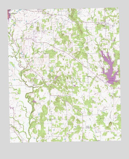
Woodbine, TX USGS Topographic Map
Click on map above to begin viewing in our Map Viewer.

This topographic map contains these locations and features:
Feature Name Type Latitude Longitude GNIS ID View Map
Anderson-Kerr Oil FieldOilfieldN33.6007°W97.0906°1351115View Map
Burns CityPopulated PlaceN33.5126°W97.0375°1379483View Map
Clark County CemeteryCemeteryN33.5598°W97.0536°1847458View Map
Dervin CemeteryCemeteryN33.6179°W97.0722°1355936View Map
Dye ChurchChurchN33.5609°W97.0361°1356507View Map
Edison Elementary SchoolSchoolN33.6232°W97.1245°2004857View Map
Este CemeteryCemeteryN33.5554°W97.0167°1357079View Map
Gainesville Southeast DivisionCivilN33.5150°W97.0241°1938765View Map
Hackley CreekStreamN33.5101°W97.1095°1358615View Map
KDGE-FM (Gainesville)TowerN33.6023°W97.0428°1385857View Map
Lake KiowaPopulated PlaceN33.5771°W97.0131°1852719View Map
Lake KiowaReservoirN33.5665°W97.0118°1360692View Map
Lake Kiowa Census Designated PlaceCensusN33.5703°W97.0129°2408540View Map
Lake Kiowa DamDamN33.5534°W97.0120°1855292View Map
Lake Kiowa Volunteer Fire DepartmentBuildingN33.5691°W97.0224°2551553View Map
Lake Kiowa Volunteer Fire Department Station 2BuildingN33.6153°W97.0252°2551788View Map
Mount Lebanon ChurchChurchN33.6057°W97.0158°1363263View Map
New Hope ChurchChurchN33.5134°W97.0386°1363744View Map
Oak Grove CemeteryCemeteryN33.6071°W97.0356°1364268View Map
Pecan CreekStreamN33.5807°W97.1170°1364969View Map
Prairie Grove Baptist ChurchChurchN33.5309°W97.0795°2017488View Map
Prairie Grove ChurchChurchN33.5212°W97.0781°1365730View Map
Rad Ware Elementary SchoolSchoolN33.6084°W97.0078°2004868View Map
Rad Ware SchoolSchoolN33.6084°W97.0078°1365941View Map
Redmond BranchStreamN33.5818°W97.1170°1366285View Map
Redmond CemeteryCemeteryN33.5832°W97.1078°1366286View Map
Robotek AirportAirportN33.5500°W97.0381°2676560View Map
Scott CreekStreamN33.5034°W97.1028°1376051View Map
Shady Grove ChurchChurchN33.6084°W97.0164°1368031View Map
Site of Fort FitzhughParkN33.5812°W97.1100°2029274View Map
Soil Conservation Service Site 16b DamDamN33.5368°W97.1003°1855290View Map
Soil Conservation Service Site 16b ReservoirReservoirN33.5368°W97.1003°1855291View Map
Temple Baptist ChurchChurchN33.6243°W97.1242°2017490View Map
Temple ChurchChurchN33.6243°W97.1239°1369697View Map
The Wilson PoolOilfieldN33.6154°W97.0592°1369814View Map
Wheeler CreekStreamN33.6007°W97.1242°1371334View Map
WoodbinePopulated PlaceN33.6107°W97.0156°1371902View Map

Note: Coordinates in the location and feature list above are referenced to NAD83 datum.


Copyright (C) 2008-2024 Ryan Niemi / Sunset Dynamics ... All Rights Reserved