TopoQuest Logo
Do you find TopoQuest useful?
Help keep TopoQuest running and adding new maps/features by donating!
Bitcoin:  19c7KJd3qBynnjoSw5npx9KScwjBe4ifkT
Litecoin:  LXs6TkuXGGXo1vDsWCkWVdjQX94eUKd6ui
Home View Maps Find Maps Find Places Resources & Links


Galen, Tennessee Topographic Map

USGS Map Title: Galen, TN
USGS Map MRC: 36085E8
DRG (GeoTIFF) Download: o36085e8.tif


Neighboring USGS Topographic Map Quads:


  Holland, KY  
36086F1
 

  Fountain Run, KY  
36085F8
 

  Gamaliel, KY  
36085F7
 

  Lafayette, TN  
36086E1
 

  Galen, TN  
36085E8
 

  Red Boiling Springs, TN  
36085E7
 

  Hillsdale, TN  
36086D1
 

  Pleasant Shade, TN  
36085D8
 

  Willette, TN  
36085D7


Map MRC Location:

N37°
W86°
N37°
W85°
H8 H7 H6 H5 H4 H3 H2 H1
G8 G7 G6 G5 G4 G3 G2 G1
F8 F7 F6 F5 F4 F3 F2 F1
E8 E7 E6 E5 E4 E3 E2 E1
D8 D7 D6 D5 D4 D3 D2 D1
C8 C7 C6 C5 C4 C3 C2 C1
B8 B7 B6 B5 B4 B3 B2 B1
A8 A7 A6 A5 A4 A3 A2 A1
N36°
W86°
N36°
W85°

Galen, TN USGS 1:24K Topographic Map Preview:
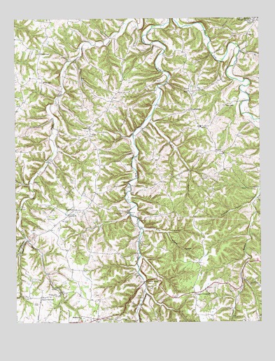
Galen, TN USGS Topographic Map
Click on map above to begin viewing in our Map Viewer.

This topographic map contains these locations and features:
Feature Name Type Latitude Longitude GNIS ID View Map
Antioch Baptist ChurchChurchN36.5803°W85.9622°1304862View Map
Beech Grove School (historical)SchoolN36.6070°W85.9455°1316331View Map
Bradley HollowValleyN36.5343°W85.9947°1305385View Map
Brooks HollowValleyN36.5370°W85.9228°1278486View Map
Commissioner District 19CivilN36.5406°W85.8960°2463890View Map
Commissioner District 3CivilN36.5736°W85.9442°2464173View Map
Commissioner District 4CivilN36.5002°W85.9941°2464064View Map
Cook CemeteryCemeteryN36.5673°W85.9816°1281119View Map
Corinth ChurchChurchN36.6181°W85.8808°1281308View Map
Corinth School (historical)SchoolN36.6184°W85.8803°1316334View Map
Cornith Gardens CemeteryCemeteryN36.6189°W85.8797°2084507View Map
Day CemeteryCemeteryN36.5105°W85.9944°2084521View Map
Days CrossroadsPopulated PlaceN36.5103°W85.9875°1314938View Map
Days Crossroads Baptist ChurchChurchN36.5106°W85.9875°1644061View Map
Dickens CemeteryCemeteryN36.5592°W85.9017°2084522View Map
Drapers CrossroadsPopulated PlaceN36.5120°W85.9089°1282785View Map
Drapers School (historical)SchoolN36.5123°W85.9055°1320130View Map
Dry BranchStreamN36.5848°W85.9311°1282872View Map
Elias McDonald CemeteryCemeteryN36.5983°W85.8975°2084564View Map
Ellis HollowValleyN36.5384°W85.9344°1283691View Map
EnonPopulated PlaceN36.5948°W85.9111°1315020View Map
Enon CemeteryCemeteryN36.5956°W85.9050°2084525View Map
Enon ChurchChurchN36.5953°W85.9058°1283816View Map
Enon SchoolSchoolN36.5803°W85.9053°1283818View Map
Friendship ChurchChurchN36.5445°W85.9733°1284948View Map
Frog PondPopulated PlaceN36.5464°W85.9700°1284968View Map
Frog Pond School (historical)SchoolN36.5448°W85.9716°1316337View Map
Frog Pond-Friendship CemeteryCemeteryN36.5420°W85.9736°1284969View Map
GalenPopulated PlaceN36.5767°W85.9619°1285084View Map
Galen School (historical)SchoolN36.5806°W85.9625°1320131View Map
Grisham HollowValleyN36.5487°W85.8794°1269609View Map
Highland School (historical)SchoolN36.5623°W85.9269°1316340View Map
Irving Meador CemeteryCemeteryN36.5611°W85.9153°2084573View Map
John Brandon CemeteryCemeteryN36.5954°W85.9052°2084463View Map
Liberty Baptist ChurchChurchN36.5448°W85.9430°1291145View Map
Liberty CemeteryCemeteryN36.5453°W85.9458°1291118View Map
Long Fork CemeteryCemeteryN36.5012°W85.9505°1291940View Map
Long Fork ChurchChurchN36.5003°W85.9597°1291941View Map
Morgan CemeteryCemeteryN36.5114°W85.9794°1294361View Map
Moss HollowValleyN36.5468°W85.9985°1294505View Map
Pleasant Grove Church (historical)ChurchN36.5451°W85.9189°1316349View Map
Poney McDonald CemeteryCemeteryN36.5014°W85.9506°2084566View Map
PumpkintownPopulated PlaceN36.5873°W85.9108°1298683View Map
Roarks Store (historical)LocaleN36.6178°W85.9833°1316352View Map
Salt LickLocaleN36.5898°W85.8900°1300590View Map
Scott CemeteryCemeteryN36.5995°W85.9258°1300941View Map
SunrisePopulated PlaceN36.5701°W85.8978°1271871View Map
Sunrise School (historical)SchoolN36.5687°W85.8928°1316359View Map
Sycamore ValleyPopulated PlaceN36.5173°W85.9280°1272010View Map
Sycamore Valley School (historical)SchoolN36.5164°W85.9336°1316355View Map
Town CreekStreamN36.5345°W85.9944°1272808View Map
UnderwoodPopulated PlaceN36.6109°W85.9869°1314430View Map
Underwood ChurchChurchN36.6109°W85.9866°1316356View Map
WebbtownPopulated PlaceN36.5003°W85.9686°1274046View Map
White OakPopulated PlaceN36.5992°W85.9864°1314501View Map
Whiteoak ChurchChurchN36.6009°W85.9922°1316358View Map
York BranchStreamN36.6114°W85.8850°1275305View Map

Note: Coordinates in the location and feature list above are referenced to NAD83 datum.


Copyright (C) 2008-2024 Ryan Niemi / Sunset Dynamics ... All Rights Reserved