TopoQuest Logo
Do you find TopoQuest useful?
Help keep TopoQuest running and adding new maps/features by donating!
Bitcoin:  19c7KJd3qBynnjoSw5npx9KScwjBe4ifkT
Litecoin:  LXs6TkuXGGXo1vDsWCkWVdjQX94eUKd6ui
Home View Maps Find Maps Find Places Resources & Links


Hillsdale, Tennessee Topographic Map

USGS Map Title: Hillsdale, TN
USGS Map MRC: 36086D1
DRG (GeoTIFF) Download: o36086d1.tif


Neighboring USGS Topographic Map Quads:


  Westmoreland, TN  
36086E2
 

  Lafayette, TN  
36086E1
 

  Galen, TN  
36085E8
 

  Hartsville, TN  
36086D2
 

  Hillsdale, TN  
36086D1
 

  Pleasant Shade, TN  
36085D8
 

  Bellwood, TN  
36086C2
 

  Dixon Springs, TN  
36086C1
 

  Carthage, TN  
36085C8


Map MRC Location:

N37°
W87°
N37°
W86°
H8 H7 H6 H5 H4 H3 H2 H1
G8 G7 G6 G5 G4 G3 G2 G1
F8 F7 F6 F5 F4 F3 F2 F1
E8 E7 E6 E5 E4 E3 E2 E1
D8 D7 D6 D5 D4 D3 D2 D1
C8 C7 C6 C5 C4 C3 C2 C1
B8 B7 B6 B5 B4 B3 B2 B1
A8 A7 A6 A5 A4 A3 A2 A1
N36°
W87°
N36°
W86°

Hillsdale, TN USGS 1:24K Topographic Map Preview:
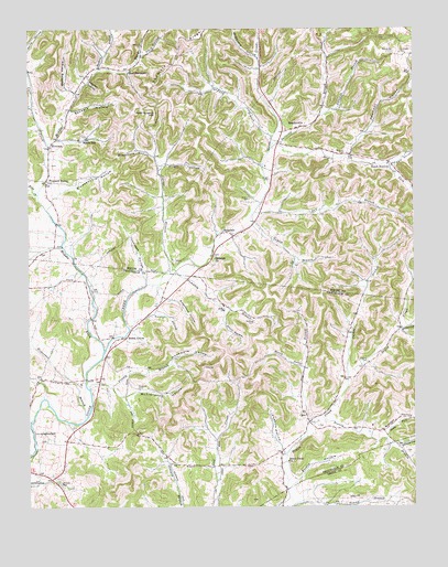
Hillsdale, TN USGS Topographic Map
Click on map above to begin viewing in our Map Viewer.

This topographic map contains these locations and features:
Feature Name Type Latitude Longitude GNIS ID View Map
Adamson HollowValleyN36.4667°W86.0213°1304766View Map
Barbers BranchStreamN36.4895°W86.1019°1304952View Map
Barnfield - Shrum - Andrews CemeteryCemeteryN36.4608°W86.0056°2084459View Map
Beech BottomPopulated PlaceN36.4653°W86.0080°1314645View Map
Beech GrovePopulated PlaceN36.4192°W86.0933°1314652View Map
Beech Grove School (historical)SchoolN36.4192°W86.0950°1323613View Map
Beech Grove United Methodist ChurchChurchN36.4228°W86.0892°1643907View Map
Beech HillPopulated PlaceN36.4712°W86.1064°1276841View Map
Beech Hill School (historical)SchoolN36.4714°W86.1083°1320128View Map
Blankenship HollowValleyN36.4561°W86.1166°1277666View Map
Burrow CemeteryCemeteryN36.4553°W86.0533°1279120View Map
Carman HollowValleyN36.4241°W86.0901°1305687View Map
Carr CreekStreamN36.4700°W86.1183°1279723View Map
Carter BranchStreamN36.4367°W86.0783°1279780View Map
CatoPopulated PlaceN36.3973°W86.0342°1305734View Map
Cato School (historical)SchoolN36.3998°W86.0358°1643677View Map
Chandler -Johnson CemeteryCemeteryN36.4934°W86.0041°1280232View Map
Charlie Wilburn CemeteryCemeteryN36.4675°W86.0222°1274519View Map
Commissioner District 15CivilN36.4773°W86.0345°2464388View Map
Commissioner District 2CivilN36.3892°W86.0592°2463978View Map
Commissioner District 3CivilN36.4162°W86.0947°2464202View Map
Commissioner District 7CivilN36.4836°W86.0757°2464629View Map
Cornwell HollowValleyN36.4127°W86.0145°1647268View Map
Dark HollowValleyN36.4641°W86.0069°1269516View Map
Dark Shrum BranchStreamN36.4642°W86.0069°1647335View Map
Deering HollowValleyN36.4835°W86.1098°1282302View Map
Dillehay HollowValleyN36.3908°W86.0051°1269528View Map
Dixon Creek ChurchChurchN36.3870°W86.0408°1306352View Map
Dog BranchStreamN36.3970°W86.0336°1282583View Map
Dry BranchStreamN36.4520°W86.0517°1282866View Map
Dry ForkStreamN36.4687°W86.0461°1282969View Map
East Fork of Goose Creek CemeteryCemeteryN36.4689°W86.0336°2084523View Map
Echo CreekStreamN36.4567°W86.1217°1283490View Map
Evitts HollowValleyN36.3812°W86.0391°1283936View Map
Finley BranchStreamN36.4059°W86.1050°1284271View Map
Fleeman CemeteryCemeteryN36.4062°W86.0897°1284459View Map
Ford BranchStreamN36.4714°W86.0458°1284561View Map
Ford HollowValleyN36.4930°W86.0877°1284574View Map
Freeman HollowValleyN36.4860°W86.1054°1284891View Map
Gaulden BranchStreamN36.4773°W86.0300°1285254View Map
Golden HollowValleyN36.4219°W86.0032°1285592View Map
Goodwill Missionary Baptist ChurchChurchN36.3864°W86.0794°1643675View Map
Greenwood HollowValleyN36.4292°W86.0796°1286209View Map
Gregory CemeteryCemeteryN36.4125°W86.0153°1286240View Map
Hard Scratch HillSummitN36.4792°W86.0844°1286801View Map
Haynie BranchStreamN36.3973°W86.1242°1287239View Map
Hickerson BranchStreamN36.3976°W86.1069°1287534View Map
HillsdalePopulated PlaceN36.4462°W86.0586°1287845View Map
Hillsdale ChurchChurchN36.4401°W86.0647°1287846View Map
Hillsdale QuarryMineN36.4411°W86.0747°2633397View Map
Holder BranchStreamN36.4403°W86.1108°1647337View Map
Honey ProngStreamN36.4114°W86.0355°1288204View Map
Horsley School (historical)SchoolN36.4695°W86.1175°1320134View Map
HorsleysPopulated PlaceN36.4695°W86.1180°1315260View Map
Jacob Eller CemeteryCemeteryN36.4453°W86.0444°2084524View Map
Jim Meador CemeteryCemeteryN36.4736°W86.0417°2084574View Map
Lovelady CemeteryCemeteryN36.4936°W86.0272°2084559View Map
Massey HollowValleyN36.3944°W86.0090°1292911View Map
McClanahan HollowValleyN36.4039°W86.0939°1293149View Map
McDonald CemeteryCemeteryN36.4937°W86.0061°1293257View Map
McDonald HollowValleyN36.4930°W86.0510°1293264View Map
Meador Family CemeteryCemeteryN36.4753°W86.0367°2084571View Map
MeadorvillePopulated PlaceN36.4745°W86.0361°1315493View Map
Meadorville Baptist ChurchChurchN36.4737°W86.0414°1644072View Map
Meadorville Graveyard CemeteryCemeteryN36.4728°W86.0458°2084577View Map
Merryman CemeteryCemeteryN36.4383°W86.0386°2084578View Map
Middle Fork Goose CreekStreamN36.4153°W86.1008°1293674View Map
Morgan CemeteryCemeteryN36.4992°W86.0683°2084582View Map
Nelson McDonald CemeteryCemeteryN36.4939°W86.0064°2084565View Map
New HarmonyPopulated PlaceN36.4892°W86.0928°1315590View Map
New Harmony Baptist ChurchChurchN36.4895°W86.0919°1644074View Map
North Fork Scanty BranchStreamN36.3928°W86.0089°1295913View Map
Old Bottom School (historical)SchoolN36.4648°W86.0083°1320136View Map
Parker BranchStreamN36.4101°W86.0214°1296796View Map
Peddlers RidgeRidgeN36.4917°W86.0778°1297103View Map
Pleasant ValleyPopulated PlaceN36.4603°W86.1194°1315743View Map
Pleasant Valley United Methodist ChurchChurchN36.4598°W86.1189°1644077View Map
Possum HollowValleyN36.3889°W86.0424°1298301View Map
Pumpkin BranchStreamN36.4373°W86.0780°1298674View Map
Sanders HollowValleyN36.4784°W86.1114°1300705View Map
Scanty BranchStreamN36.3987°W86.0300°1300864View Map
Short HollowValleyN36.4263°W86.0612°1270202View Map
South Fork Young BranchStreamN36.3756°W86.0286°1270890View Map
Stafford CemeteryCemeteryN36.4231°W86.0516°1271191View Map
Stalcup CemeteryCemeteryN36.3814°W86.1153°1271202View Map
Suggs HollowValleyN36.3932°W86.0652°1647267View Map
Sullivan BranchStreamN36.4698°W86.0447°1271749View Map
Taylor BranchStreamN36.4489°W86.0525°1272187View Map
Thompson HollowValleyN36.4334°W86.0869°1272551View Map
W H Wright CemeteryCemeteryN36.4609°W86.0466°1275173View Map
Wallace CemeteryCemeteryN36.4267°W86.0611°1273678View Map
William McClard CemeteryCemeteryN36.4364°W86.0406°2084561View Map
Woodmore HollowValleyN36.4077°W86.0973°1275063View Map
Woodmore HollowValleyN36.4673°W86.0839°1275064View Map
Wright HollowValleyN36.4645°W86.0802°1275180View Map

Note: Coordinates in the location and feature list above are referenced to NAD83 datum.


Copyright (C) 2008-2024 Ryan Niemi / Sunset Dynamics ... All Rights Reserved