TopoQuest Logo
Do you find TopoQuest useful?
Help keep TopoQuest running and adding new maps/features by donating!
Bitcoin:  19c7KJd3qBynnjoSw5npx9KScwjBe4ifkT
Litecoin:  LXs6TkuXGGXo1vDsWCkWVdjQX94eUKd6ui
Home View Maps Find Maps Find Places Resources & Links


Holland, Kentucky Topographic Map

USGS Map Title: Holland, KY
USGS Map MRC: 36086F1
DRG (GeoTIFF) Download: o36086f1.tif


Neighboring USGS Topographic Map Quads:


  Scottsville, KY  
36086G2
 

  Austin, KY  
36086G1
 

  Tracy, KY  
36085G8
 

  Petroleum, KY  
36086F2
 

  Holland, KY  
36086F1
 

  Fountain Run, KY  
36085F8
 

  Westmoreland, TN  
36086E2
 

  Lafayette, TN  
36086E1
 

  Galen, TN  
36085E8


Map MRC Location:

N37°
W87°
N37°
W86°
H8 H7 H6 H5 H4 H3 H2 H1
G8 G7 G6 G5 G4 G3 G2 G1
F8 F7 F6 F5 F4 F3 F2 F1
E8 E7 E6 E5 E4 E3 E2 E1
D8 D7 D6 D5 D4 D3 D2 D1
C8 C7 C6 C5 C4 C3 C2 C1
B8 B7 B6 B5 B4 B3 B2 B1
A8 A7 A6 A5 A4 A3 A2 A1
N36°
W87°
N36°
W86°

Holland, KY USGS 1:24K Topographic Map Preview:
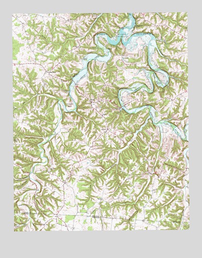
Holland, KY USGS Topographic Map
Click on map above to begin viewing in our Map Viewer.

This topographic map contains these locations and features:
Feature Name Type Latitude Longitude GNIS ID View Map
AmosPopulated PlaceN36.6525°W86.0883°485927View Map
Bandy CemeteryCemeteryN36.6653°W86.0294°486312View Map
Benedict BranchStreamN36.7314°W86.0253°486846View Map
Calvert SpringSpringN36.7237°W86.0748°488649View Map
Doddy BranchStreamN36.6570°W86.1136°490953View Map
Dry CreekStreamN36.7009°W86.0905°491171View Map
East Allen Fire DepartmentBuildingN36.6807°W86.0608°2636984View Map
Emma Cook HollowValleyN36.6557°W86.1150°485681View Map
Figure Eight BranchStreamN36.6767°W86.0022°492076View Map
Hanging Rock BranchStreamN36.6331°W86.1130°1647336View Map
Hanging Rock HollowValleyN36.6330°W86.1144°1286724View Map
HayesvillePopulated PlaceN36.6337°W86.0944°1315210View Map
Highland ChurchChurchN36.6434°W86.0622°494204View Map
Hilburn SpringSpringN36.6773°W86.1247°494239View Map
HollandPopulated PlaceN36.6989°W86.0683°494393View Map
Holland DivisionCivilN36.6811°W86.0488°1937065View Map
Horseshoe BendBendN36.6975°W86.0836°494598View Map
Jewsharp BendBendN36.7114°W86.0230°495260View Map
Liberty ChurchChurchN36.6956°W86.1247°496360View Map
Long CreekStreamN36.7358°W86.0642°497094View Map
Long Hungry CreekStreamN36.6903°W86.0268°497122View Map
Maysville ChurchChurchN36.7456°W86.0844°497753View Map
Mount Gilead ChurchChurchN36.7303°W86.0767°498730View Map
Mount ZionPopulated PlaceN36.6831°W86.0572°498910View Map
Mount Zion SchoolSchoolN36.6914°W86.0603°498954View Map
New Salem ChurchChurchN36.6603°W86.0989°499385View Map
Oak ForestPopulated PlaceN36.7159°W86.0983°508727View Map
Pinchgut CreekStreamN36.6864°W86.0194°500658View Map
Red Hill ChurchChurchN36.6478°W86.0258°501655View Map
Roark CemeteryCemeteryN36.6512°W86.0003°502045View Map
The SinkBasinN36.7292°W86.0550°505144View Map
Turkeyfoot CreekStreamN36.6402°W86.0392°505636View Map
Walnut HillPopulated PlaceN36.7231°W86.0458°509310View Map

Note: Coordinates in the location and feature list above are referenced to NAD83 datum.


Copyright (C) 2008-2025 Ryan Niemi / Sunset Dynamics ... All Rights Reserved