TopoQuest Logo
Do you find TopoQuest useful?
Help keep TopoQuest running and adding new maps/features by donating!
Bitcoin:  19c7KJd3qBynnjoSw5npx9KScwjBe4ifkT
Litecoin:  LXs6TkuXGGXo1vDsWCkWVdjQX94eUKd6ui
Home View Maps Find Maps Find Places Resources & Links


Gallia, Ohio Topographic Map

USGS Map Title: Gallia, OH
USGS Map MRC: 38082G5
DRG (GeoTIFF) Download: o38082g5.tif


Neighboring USGS Topographic Map Quads:


  Petersburg, OH  
38082H6
 

  Oak Hill, OH  
38082H5
 

  Rio Grande, OH  
38082H4
 

  South Webster, OH  
38082G6
 

  Gallia, OH  
38082G5
 

  Patriot, OH  
38082G4
 

  Pedro, OH  
38082F6
 

  Sherritts, OH  
38082F5
 

  Waterloo, OH  
38082F4


Map MRC Location:

N39°
W83°
N39°
W82°
H8 H7 H6 H5 H4 H3 H2 H1
G8 G7 G6 G5 G4 G3 G2 G1
F8 F7 F6 F5 F4 F3 F2 F1
E8 E7 E6 E5 E4 E3 E2 E1
D8 D7 D6 D5 D4 D3 D2 D1
C8 C7 C6 C5 C4 C3 C2 C1
B8 B7 B6 B5 B4 B3 B2 B1
A8 A7 A6 A5 A4 A3 A2 A1
N38°
W83°
N38°
W82°

Gallia, OH USGS 1:24K Topographic Map Preview:
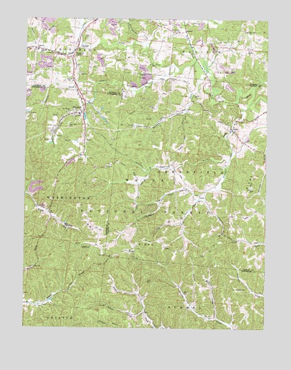
Gallia, OH USGS Topographic Map
Click on map above to begin viewing in our Map Viewer.

This topographic map contains these locations and features:
Feature Name Type Latitude Longitude GNIS ID View Map
Bethel CemeteryCemeteryN38.8531°W82.5971°1964015View Map
Bethel Presbyterian ChurchChurchN38.8529°W82.5971°1075360View Map
Black ForkStreamN38.8748°W82.5988°1075391View Map
BlackforkPopulated PlaceN38.8376°W82.5999°1075393View Map
Blackfork Elementary SchoolSchoolN38.8365°W82.5971°1050571View Map
Blackfork JunctionPopulated PlaceN38.8604°W82.6004°1075394View Map
Blackfork Post OfficePost OfficeN38.8376°W82.5999°2025725View Map
Bryn Hyfryd ChurchChurchN38.8695°W82.5460°1038441View Map
Cambria CreekStreamN38.8565°W82.5477°1075511View Map
Clear ForkStreamN38.8523°W82.5318°1075588View Map
Dicks CreekStreamN38.8556°W82.5343°1075714View Map
Dirtyface CreekStreamN38.8481°W82.5068°1066680View Map
Dry RidgeRidgeN38.7845°W82.5593°1039804View Map
GalliaPopulated PlaceN38.8309°W82.5177°1051226View Map
Gallia CemeteryCemeteryN38.8073°W82.5077°1068773View Map
Gallia CemeteryCemeteryN38.8320°W82.5193°1964048View Map
Gallia ChurchChurchN38.8070°W82.5079°1075891View Map
Gallia Post Office (historical)Post OfficeN38.8306°W82.5179°1987735View Map
Gallia SchoolSchoolN38.8262°W82.5110°1075918View Map
Gallia SchoolSchoolN38.8256°W82.5110°1051227View Map
Greenfield Township Volunteer Fire DepartmentBuildingN38.8262°W82.5105°2549437View Map
HoadleyPopulated PlaceN38.7812°W82.5715°1076054View Map
Hoadley Post Office (historical)Post OfficeN38.7806°W82.5721°1987746View Map
Hoadley Station (historical)LocaleN38.7787°W82.5807°1067441View Map
Huntingcamp CreekStreamN38.8640°W82.5629°1076097View Map
Indian CreekStreamN38.7562°W82.5624°1076112View Map
Irish HollowValleyN38.8370°W82.5971°1076117View Map
Jefferson SchoolSchoolN38.8623°W82.6191°1076137View Map
KitchenPopulated PlaceN38.8698°W82.5427°1076187View Map
Kitchen Post Office (historical)Post OfficeN38.8695°W82.5429°2013735View Map
Kokeene HollowValleyN38.8370°W82.5435°1076192View Map
McCulgan CemeteryCemeteryN38.8703°W82.5115°1076359View Map
Miller CreekStreamN38.7542°W82.5249°1076393View Map
Old Country TabernacleChurchN38.8637°W82.5968°1076555View Map
PenielPopulated PlaceN38.8040°W82.5338°1076614View Map
Peniel CemeteryCemeteryN38.8039°W82.5346°1964068View Map
Peniel Post Office (historical)Post OfficeN38.8042°W82.5332°1988264View Map
Peniel Presbyterian ChurchChurchN38.8037°W82.5346°1068788View Map
Poetkner CemeteryCemeteryN38.8495°W82.6029°1076665View Map
Pokepatch HollowValleyN38.8190°W82.5202°1066446View Map
Sardis CemeteryCemeteryN38.8631°W82.5099°1964030View Map
Sardis Presbyterian ChurchChurchN38.8629°W82.5096°1076835View Map
Shaffer CemeteryCemeteryN38.8440°W82.5379°1076862View Map
Telegraph Hill Lookout TowerTowerN38.7826°W82.5902°1080210View Map
Thompson CemeteryCemeteryN38.7662°W82.5149°1077043View Map
Township of GreenfieldCivilN38.8123°W82.5191°1086137View Map
Township of WashingtonCivilN38.8033°W82.6174°1086450View Map
Union Baptist CemeteryCemeteryN38.8148°W82.5829°1961223View Map
Union Baptist ChurchChurchN38.8154°W82.5832°1077102View Map
Union CemeteryCemeteryN38.8737°W82.5388°1077097View Map
Washington CemeteryCemeteryN38.8315°W82.6027°1077140View Map
West CemeteryCemeteryN38.8670°W82.5938°1077167View Map
Wood CemeteryCemeteryN38.8000°W82.5571°1077228View Map

Note: Coordinates in the location and feature list above are referenced to NAD83 datum.


Copyright (C) 2008-2024 Ryan Niemi / Sunset Dynamics ... All Rights Reserved