TopoQuest Logo
Do you find TopoQuest useful?
Help keep TopoQuest running and adding new maps/features by donating!
Bitcoin:  19c7KJd3qBynnjoSw5npx9KScwjBe4ifkT
Litecoin:  LXs6TkuXGGXo1vDsWCkWVdjQX94eUKd6ui
Home View Maps Find Maps Find Places Resources & Links


Sherritts, Ohio Topographic Map

USGS Map Title: Sherritts, OH
USGS Map MRC: 38082F5
DRG (GeoTIFF) Download: o38082f5.tif


Neighboring USGS Topographic Map Quads:


  South Webster, OH  
38082G6
 

  Gallia, OH  
38082G5
 

  Patriot, OH  
38082G4
 

  Pedro, OH  
38082F6
 

  Sherritts, OH  
38082F5
 

  Waterloo, OH  
38082F4
 

  Ironton, OH  
38082E6
 

  Kitts Hill, OH  
38082E5
 

  Aid, OH  
38082E4


Map MRC Location:

N39°
W83°
N39°
W82°
H8 H7 H6 H5 H4 H3 H2 H1
G8 G7 G6 G5 G4 G3 G2 G1
F8 F7 F6 F5 F4 F3 F2 F1
E8 E7 E6 E5 E4 E3 E2 E1
D8 D7 D6 D5 D4 D3 D2 D1
C8 C7 C6 C5 C4 C3 C2 C1
B8 B7 B6 B5 B4 B3 B2 B1
A8 A7 A6 A5 A4 A3 A2 A1
N38°
W83°
N38°
W82°

Sherritts, OH USGS 1:24K Topographic Map Preview:
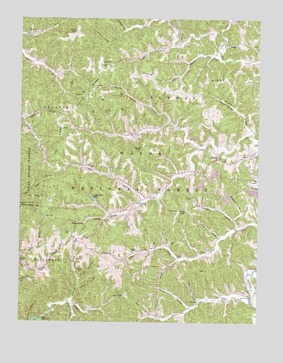
Sherritts, OH USGS Topographic Map
Click on map above to begin viewing in our Map Viewer.

This topographic map contains these locations and features:
Feature Name Type Latitude Longitude GNIS ID View Map
Aldridge CemeteryCemeteryN38.6459°W82.5929°1075247View Map
Aldridge HollowValleyN38.6342°W82.5968°1037356View Map
Arbaugh HollowValleyN38.6426°W82.5935°1075272View Map
Asbury CreekStreamN38.7495°W82.5552°1075284View Map
Bakers Fork Buffalo CreekStreamN38.7337°W82.5199°1075298View Map
Barnett CemeteryCemeteryN38.6278°W82.5521°1698952View Map
Beech Fork Buffalo CreekStreamN38.7384°W82.5446°1075338View Map
Boggs CemeteryCemeteryN38.6465°W82.5260°1075417View Map
Bowen CemeteryCemeteryN38.6684°W82.6113°1075428View Map
Brushy Buckeye CreekStreamN38.7073°W82.5457°1075460View Map
Buckeye CreekStreamN38.6970°W82.5315°1075470View Map
Buffalo CemeteryCemeteryN38.7387°W82.5121°1961196View Map
Cade HollowValleyN38.6779°W82.6243°1075500View Map
Caulley CreekStreamN38.7367°W82.5210°1075536View Map
Cedar Cliff HollowValleyN38.6342°W82.5307°1075541View Map
Clarkson HollowValleyN38.7454°W82.5696°1075579View Map
Cooper CemeteryCemeteryN38.6984°W82.5007°1961668View Map
Dean HollowValleyN38.6287°W82.5554°1075690View Map
Dennin CemeteryCemeteryN38.6762°W82.5371°1075701View Map
Elkins CreekStreamN38.6334°W82.5038°1075801View Map
Forest RidgeRidgeN38.7184°W82.5885°1075865View Map
George McClure Pond DamDamN38.6484°W82.5449°1079274View Map
Gum Stump HollowValleyN38.6651°W82.5107°1075973View Map
Handley BranchStreamN38.7031°W82.5046°1075991View Map
Hungry HollowValleyN38.7312°W82.5371°1076092View Map
Izaak Walton LakeReservoirN38.6761°W82.5865°1079261View Map
Izaak Walton Lake DamDamN38.6751°W82.5849°1079260View Map
Jennick CemeteryCemeteryN38.6542°W82.5646°1076141View Map
Joe Delawder CemeteryCemeteryN38.6526°W82.5899°1698955View Map
John Neal CemeteryCemeteryN38.6520°W82.5588°1698956View Map
Johns Creek (historical)Populated PlaceN38.6712°W82.5688°1067477View Map
Johns Creek Post Office (historical)Post OfficeN38.6709°W82.5688°2025797View Map
Kanady HollowValleyN38.6395°W82.5927°1076163View Map
Kimble Lookout TowerTowerN38.6356°W82.5704°1080125View Map
Lambert HollowValleyN38.7404°W82.5785°1076204View Map
Leet RidgeRidgeN38.6762°W82.6174°1076229View Map
Littles CemeteryCemeteryN38.7181°W82.5918°1076283View Map
Macedonia CemeteryCemeteryN38.7315°W82.5774°1961207View Map
Macedonia ChurchChurchN38.7315°W82.5771°1076321View Map
McClure LakeReservoirN38.6472°W82.5462°1083370View Map
Nelson BridgeBridgeN38.6362°W82.5038°1076503View Map
Nelson CemeteryCemeteryN38.6378°W82.5060°1698958View Map
Paddle CreekStreamN38.6323°W82.5974°1076587View Map
Palestine ChurchChurchN38.6998°W82.5332°1076593View Map
Perry CemeteryCemeteryN38.6620°W82.6007°1076619View Map
Peters RunStreamN38.7070°W82.6232°1076623View Map
Phillips KnobSummitN38.7448°W82.5960°1066448View Map
Rehobeth ChurchChurchN38.7392°W82.5124°1077327View Map
Robinson CemeteryCemeteryN38.6712°W82.5415°1076748View Map
Rucker CemeteryCemeteryN38.6428°W82.5677°1698963View Map
Sam Miller HollowValleyN38.7045°W82.5052°1076816View Map
Schweickart HollowValleyN38.6673°W82.5804°1076851View Map
Shelton HollowValleyN38.6254°W82.6188°1076881View Map
SherrittsPopulated PlaceN38.6926°W82.5207°1085487View Map
Sherritts Post Office (historical)Post OfficeN38.6931°W82.5207°2026023View Map
Slab Fork ChurchChurchN38.6737°W82.5621°1076907View Map
Slab Fork Church CemeteryCemeteryN38.6731°W82.5618°1961673View Map
Slab Fork Johns CreekStreamN38.6748°W82.5596°1076908View Map
Stewart KnobSummitN38.6954°W82.5627°1076970View Map
Stewart-Werner CemeteryCemeteryN38.6792°W82.5818°1698965View Map
Thompson CemeteryCemeteryN38.6856°W82.6113°1077044View Map
Tick RidgeRidgeN38.7217°W82.5302°1077050View Map
Tipton KnobSummitN38.6709°W82.5379°1077056View Map
Townsend HollowValleyN38.6684°W82.5115°1077062View Map
Township of AidCivilN38.6412°W82.5375°1086438View Map
Township of SymmesCivilN38.7290°W82.5312°1086447View Map
Walters CemeteryCemeteryN38.6478°W82.5821°1698966View Map
Waugh HollowValleyN38.6317°W82.5363°1077148View Map
Wayne National ForestForestN38.6994°W82.5147°1048405View Map
White HollowValleyN38.6606°W82.5202°1077178View Map
White HollowValleyN38.7070°W82.6224°1077183View Map
Wiseman CemeteryCemeteryN38.6965°W82.5077°1961676View Map
Woltz HollowValleyN38.6520°W82.6238°1077227View Map
Yates CemeteryCemeteryN38.6481°W82.5554°1077240View Map
Yates CemeteryCemeteryN38.6631°W82.5593°1698967View Map
Zoar ChurchChurchN38.7042°W82.6024°1077259View Map
Zoar RidgeRidgeN38.6992°W82.6013°1077261View Map

Note: Coordinates in the location and feature list above are referenced to NAD83 datum.


Copyright (C) 2008-2025 Ryan Niemi / Sunset Dynamics ... All Rights Reserved