TopoQuest Logo
Do you find TopoQuest useful?
Help keep TopoQuest running and adding new maps/features by donating!
Bitcoin:  19c7KJd3qBynnjoSw5npx9KScwjBe4ifkT
Litecoin:  LXs6TkuXGGXo1vDsWCkWVdjQX94eUKd6ui
Home View Maps Find Maps Find Places Resources & Links


Gansevoort, New York Topographic Map

USGS Map Title: Gansevoort, NY
USGS Map MRC: 43073B6
DRG (GeoTIFF) Download: o43073b6.tif


Neighboring USGS Topographic Map Quads:


  Lake Luzerne, NY  
43073C7
 

  Glens Falls, NY  
43073C6
 

  Hudson Falls, NY  
43073C5
 

  Corinth, NY  
43073B7
 

  Gansevoort, NY  
43073B6
 

  Fort Miller, NY  
43073B5
 

  Saratoga Springs, NY  
43073A7
 

  Quaker Springs, NY  
43073A6
 

  Schuylerville, NY  
43073A5


Map MRC Location:

N44°
W74°
N44°
W73°
H8 H7 H6 H5 H4 H3 H2 H1
G8 G7 G6 G5 G4 G3 G2 G1
F8 F7 F6 F5 F4 F3 F2 F1
E8 E7 E6 E5 E4 E3 E2 E1
D8 D7 D6 D5 D4 D3 D2 D1
C8 C7 C6 C5 C4 C3 C2 C1
B8 B7 B6 B5 B4 B3 B2 B1
A8 A7 A6 A5 A4 A3 A2 A1
N43°
W74°
N43°
W73°

Gansevoort, NY USGS 1:24K Topographic Map Preview:
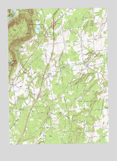
Gansevoort, NY USGS Topographic Map
Click on map above to begin viewing in our Map Viewer.

This topographic map contains these locations and features:
Feature Name Type Latitude Longitude GNIS ID View Map
Adirondack EstatesPopulated PlaceN43.1794°W73.7131°2435471View Map
Airway Meadows Golf CourseLocaleN43.1806°W73.6325°2435480View Map
Ariels Farm And GreenhouseLocaleN43.1492°W73.7406°2519105View Map
Arnoldeyre FarmLocaleN43.2111°W73.6861°2519134View Map
Ashfords WayPopulated PlaceN43.2119°W73.7208°2435470View Map
Aust's Open Air Theatre (historical)LocaleN43.2444°W73.6825°2557917View Map
Ballard CornersPopulated PlaceN43.1531°W73.6815°942923View Map
Ballard Elementary SchoolSchoolN43.1784°W73.7351°942926View Map
Barnes CornersLocaleN43.1331°W73.7073°943042View Map
Brick Church CemeteryCemeteryN43.1547°W73.7404°2677326View Map
Callahans CornersLocaleN43.1567°W73.6257°945473View Map
Camp SaratogaLocaleN43.1534°W73.7012°945658View Map
CastlewoodPopulated PlaceN43.1361°W73.6639°2435484View Map
Church of GodChurchN43.1370°W73.7040°2615751View Map
Clarks CornerPopulated PlaceN43.2215°W73.6415°946783View Map
Cole BrookStreamN43.2037°W73.6301°947097View Map
Delegan BrookStreamN43.1848°W73.7026°948272View Map
Dimmick CemeteryCemeteryN43.1889°W73.6991°2424889View Map
Dimmick CornersLocaleN43.1901°W73.6996°948460View Map
Dorothy Nolan Elementary SchoolSchoolN43.1254°W73.7468°958644View Map
Emersons Corners CemeteryCemeteryN43.1707°W73.7162°2424891View Map
English VillagePopulated PlaceN43.2481°W73.6833°2499289View Map
Forest HillsPopulated PlaceN43.1583°W73.6361°2435482View Map
FortsvillePopulated PlaceN43.2301°W73.6818°950506View Map
Fox Run EstatesPopulated PlaceN43.1575°W73.6800°2435474View Map
GansevoortPopulated PlaceN43.1962°W73.6518°950871View Map
Gansevoort CemeteryCemeteryN43.1908°W73.6491°2426133View Map
Gansevoort Post OfficePost OfficeN43.2023°W73.6453°2617935View Map
Gansevoort Volunteer Fire DepartmentBuildingN43.1942°W73.6446°2735211View Map
Grant MountainSummitN43.2304°W73.7401°951518View Map
Grants WoodsPopulated PlaceN43.2078°W73.7228°2435469View Map
Griswold CemeteryCemeteryN43.2459°W73.6768°951834View Map
Gurn SpringPopulated PlaceN43.1709°W73.7176°951955View Map
Gurn Springs CemeteryCemeteryN43.1714°W73.7151°2424890View Map
Heber AirparkAirportN43.1825°W73.6349°978027View Map
Hickory ForestPopulated PlaceN43.1703°W73.6614°2435477View Map
Hurds BrookStreamN43.1681°W73.6271°953518View Map
Interchange 16CrossingN43.1695°W73.7121°974442View Map
Interchange 17CrossingN43.2356°W73.6926°974447View Map
Kidron Brook Paint And Quarter Horse FarmLocaleN43.2081°W73.6992°2543431View Map
Kingdom Hall of Jehovahs WitnessesChurchN43.1317°W73.7077°2616593View Map
Little Snook KillStreamN43.1865°W73.7187°955696View Map
Miller SwampSwampN43.1317°W73.7001°957325View Map
Moreau LakeLakeN43.2313°W73.7116°957646View Map
Moreau Lake State ParkParkN43.2345°W73.7137°957647View Map
Mount McGregor Correctional FacilityBuildingN43.2007°W73.7473°2438488View Map
Mount McGregor State Hospital (historical)HospitalN43.2009°W73.7482°957858View Map
Northumberland Town HallBuildingN43.1988°W73.6513°2617658View Map
Palmer RidgeRidgeN43.2056°W73.6840°959797View Map
Queens CourtPopulated PlaceN43.1333°W73.6619°2435485View Map
Rice BrookStreamN43.1973°W73.6321°962447View Map
Rimbrave EstatesPopulated PlaceN43.1572°W73.6703°2435475View Map
Russell FieldAirportN43.1456°W73.6542°978192View Map
Saddle LakeLakeN43.2132°W73.7356°963205View Map
Saddle Lake CampLocaleN43.2120°W73.7368°963206View Map
Sandy OaksPopulated PlaceN43.2469°W73.6606°2499294View Map
Schuyler HeightsPopulated PlaceN43.1914°W73.6444°2435479View Map
Shaw Field Airport (historical)AirportN43.1997°W73.6327°978038View Map
Shelley Trailer ParkPopulated PlaceN43.1711°W73.6453°2435481View Map
South Wilton CemeteryCemeteryN43.1296°W73.7113°2424892View Map
StonegatePopulated PlaceN43.1594°W73.6583°2435476View Map
Strawberry AcresPopulated PlaceN43.2461°W73.6658°2499291View Map
Tanager WoodsPopulated PlaceN43.1783°W73.6569°2435478View Map
Terrel HillsPopulated PlaceN43.1425°W73.6611°2435483View Map
Town of MoreauCivilN43.2469°W73.6659°979236View Map
Town of NorthumberlandCivilN43.1621°W73.6306°979294View Map
Town of WiltonCivilN43.1502°W73.7276°979647View Map
Travers CornersPopulated PlaceN43.1567°W73.7335°967765View Map
Trinity United Methodist ChurchChurchN43.1706°W73.7154°2616383View Map
Whispering Pines Mobile Home ParkPopulated PlaceN43.1656°W73.6986°2435473View Map
Wild At Heart FarmLocaleN43.2306°W73.6314°2519146View Map
WiltonPopulated PlaceN43.1801°W73.7443°971433View Map
Wilton Commerce ParkLocaleN43.1661°W73.7064°2435472View Map
Wilton EmergencyBuildingN43.1255°W73.7343°2735225View Map
Wilton Emergency SquadBuildingN43.1253°W73.7345°2720216View Map
Wilton Volunteer Fire Department Station 1BuildingN43.1770°W73.7325°2735223View Map
Wilton Volunteer Fire Department Station 2BuildingN43.1359°W73.7027°2735224View Map

Note: Coordinates in the location and feature list above are referenced to NAD83 datum.


Copyright (C) 2008-2024 Ryan Niemi / Sunset Dynamics ... All Rights Reserved