TopoQuest Logo
Do you find TopoQuest useful?
Help keep TopoQuest running and adding new maps/features by donating!
Bitcoin:  19c7KJd3qBynnjoSw5npx9KScwjBe4ifkT
Litecoin:  LXs6TkuXGGXo1vDsWCkWVdjQX94eUKd6ui
Home View Maps Find Maps Find Places Resources & Links


Garden Mountain, Virginia Topographic Map

USGS Map Title: Garden Mountain, VA
USGS Map MRC: 37081A3
DRG (GeoTIFF) Download: o37081a3.tif


Neighboring USGS Topographic Map Quads:


  Tiptop, VA  
37081B4
 

  Cove Creek, VA  
37081B3
 

  Bastian, VA  
37081B2
 

  Hutchinson Rock, VA  
37081A4
 

  Garden Mountain, VA  
37081A3
 

  Big Bend, VA  
37081A2
 

  Nebo, VA  
36081H4
 

  Rural Retreat, VA  
36081H3
 

  Crockett, VA  
36081H2


Map MRC Location:

N38°
W82°
N38°
W81°
H8 H7 H6 H5 H4 H3 H2 H1
G8 G7 G6 G5 G4 G3 G2 G1
F8 F7 F6 F5 F4 F3 F2 F1
E8 E7 E6 E5 E4 E3 E2 E1
D8 D7 D6 D5 D4 D3 D2 D1
C8 C7 C6 C5 C4 C3 C2 C1
B8 B7 B6 B5 B4 B3 B2 B1
A8 A7 A6 A5 A4 A3 A2 A1
N37°
W82°
N37°
W81°

Garden Mountain, VA USGS 1:24K Topographic Map Preview:
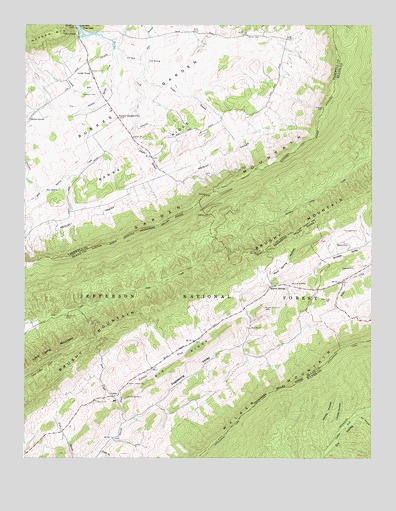
Garden Mountain, VA USGS Topographic Map
Click on map above to begin viewing in our Map Viewer.

This topographic map contains these locations and features:
Feature Name Type Latitude Longitude GNIS ID View Map
Alum Spring HollowValleyN37.0517°W81.2865°1481301View Map
Banks RidgeRidgeN37.0915°W81.3240°1481443View Map
Big RidgeRidgeN37.0279°W81.3190°1481765View Map
Blue SpringSpringN37.0769°W81.3673°1481863View Map
Blue Spring CreekStreamN37.0935°W81.3359°1481866View Map
Brown CemeteryCemeteryN37.1218°W81.2937°1482031View Map
Bucks BranchStreamN37.0021°W81.3479°1482140View Map
Burkes GardenBasinN37.1012°W81.3379°1482171View Map
Burkes GardenPopulated PlaceN37.0982°W81.3409°1498460View Map
Burkes Garden AirportAirportN37.0982°W81.3663°1498826View Map
Burkes Garden Central Church Lutheran CemeteryCemeteryN37.0923°W81.3354°1497609View Map
Burkes Garden High School (historical)SchoolN37.1001°W81.3437°1497610View Map
Burkes Garden Post OfficePost OfficeN37.0982°W81.3409°1500361View Map
Burkes Garden Rural Historic DistrictParkN37.0982°W81.3415°1497611View Map
Burkes Garden Volunteer Fire DepartmentBuildingN37.1113°W81.3513°2085881View Map
Central ChurchChurchN37.0921°W81.3354°1482429View Map
CeresPopulated PlaceN37.0179°W81.3429°1494870View Map
Ceres Post OfficePost OfficeN37.0252°W81.3306°2766173View Map
Ceres Volunteer Fire DepartmentBuildingN37.0255°W81.3296°2075543View Map
Crabtree CemeteryCemeteryN37.0548°W81.2557°1482790View Map
Crooked RunStreamN37.1087°W81.3448°1482850View Map
District 1CivilN37.0691°W81.2745°1952416View Map
Fish SpringSpringN37.1143°W81.3303°1483424View Map
Foglesong ValleyValleyN37.0095°W81.3386°1483469View Map
Garden Mountain WildernessReserveN37.0547°W81.3377°2767369View Map
Gose BranchStreamN37.1148°W81.3323°1483714View Map
Gullion Fork Fishing PondsLakeN37.0115°W81.2504°1488730View Map
Houndshell CemeteryCemeteryN37.0654°W81.2543°1484242View Map
Jacobs HollowValleyN37.0037°W81.2653°1484394View Map
Jenkins ShelterLocaleN37.0871°W81.2529°1488647View Map
Laurel HollowValleyN37.0097°W81.2601°1484715View Map
Little TownPopulated PlaceN37.1140°W81.3520°1495041View Map
Medley ValleyBasinN37.0693°W81.3526°1485349View Map
North Holston ChurchChurchN37.0212°W81.3370°1485909View Map
Red Oak CemeteryCemeteryN37.0376°W81.2945°1494654View Map
Red Oak ChurchChurchN37.0376°W81.2934°1486538View Map
Redoak School (historical)SchoolN37.0343°W81.2932°1497816View Map
Rhudy BranchStreamN37.0935°W81.3359°1486578View Map
Sharon CemeteryCemeteryN37.0159°W81.3498°1494657View Map
Sharon ChurchChurchN37.0162°W81.3490°1487150View Map
Sharon District (historical)CivilN37.0348°W81.3126°1927495View Map
Sharon SpringsSpringN37.0505°W81.2793°1487154View Map
Sharon SpringsPopulated PlaceN37.0496°W81.2862°1495121View Map
Shewey CemeteryCemeteryN37.0612°W81.2590°1487189View Map
Shewey ValleyValleyN37.0534°W81.2724°1487190View Map
Six HollowValleyN37.0117°W81.2541°1487271View Map
Snyder BranchStreamN37.1096°W81.3320°1487377View Map
Soap CreekStreamN37.0104°W81.3379°1487378View Map
Spracher PlacePopulated PlaceN37.1210°W81.2807°1497737View Map
Station SpringSpringN37.0979°W81.3731°1487538View Map
Station Spring CreekStreamN37.1087°W81.3448°1487540View Map
Thompson CemeteryCemeteryN37.1043°W81.3493°1487878View Map

Note: Coordinates in the location and feature list above are referenced to NAD83 datum.


Copyright (C) 2008-2025 Ryan Niemi / Sunset Dynamics ... All Rights Reserved