TopoQuest Logo
Do you find TopoQuest useful?
Help keep TopoQuest running and adding new maps/features by donating!
Bitcoin:  19c7KJd3qBynnjoSw5npx9KScwjBe4ifkT
Litecoin:  LXs6TkuXGGXo1vDsWCkWVdjQX94eUKd6ui
Home View Maps Find Maps Find Places Resources & Links


Hutchinson Rock, Virginia Topographic Map

USGS Map Title: Hutchinson Rock, VA
USGS Map MRC: 37081A4
DRG (GeoTIFF) Download: o37081a4.tif


Neighboring USGS Topographic Map Quads:


  Tazewell North, VA  
37081B5
 

  Tiptop, VA  
37081B4
 

  Cove Creek, VA  
37081B3
 

  Tazewell South, VA  
37081A5
 

  Hutchinson Rock, VA  
37081A4
 

  Garden Mountain, VA  
37081A3
 

  Chatham Hill, VA  
36081H5
 

  Nebo, VA  
36081H4
 

  Rural Retreat, VA  
36081H3


Map MRC Location:

N38°
W82°
N38°
W81°
H8 H7 H6 H5 H4 H3 H2 H1
G8 G7 G6 G5 G4 G3 G2 G1
F8 F7 F6 F5 F4 F3 F2 F1
E8 E7 E6 E5 E4 E3 E2 E1
D8 D7 D6 D5 D4 D3 D2 D1
C8 C7 C6 C5 C4 C3 C2 C1
B8 B7 B6 B5 B4 B3 B2 B1
A8 A7 A6 A5 A4 A3 A2 A1
N37°
W82°
N37°
W81°

Hutchinson Rock, VA USGS 1:24K Topographic Map Preview:
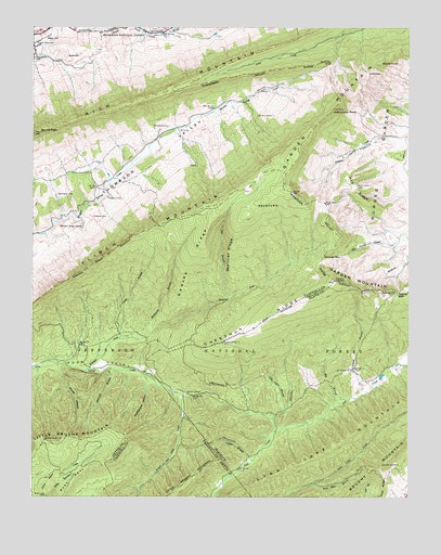
Hutchinson Rock, VA USGS Topographic Map
Click on map above to begin viewing in our Map Viewer.

This topographic map contains these locations and features:
Feature Name Type Latitude Longitude GNIS ID View Map
Alder Cabin BranchStreamN37.0226°W81.4154°1481271View Map
Bald HillSummitN37.1157°W81.4887°1495221View Map
Barkcamp BranchStreamN37.0415°W81.4704°1481458View Map
Beartown RidgeRidgeN37.0632°W81.4337°1481552View Map
Beartown WildernessReserveN37.0630°W81.4355°2035047View Map
Beavers Brook SpringSpringN37.0718°W81.4834°1481575View Map
Big BranchStreamN37.0257°W81.3951°1481704View Map
Bobs SpurRidgeN37.0043°W81.4862°1481899View Map
Buchanan CemeteryCemeteryN37.0793°W81.4918°1482103View Map
Carilion Tazewell Community HospitalHospitalN37.1239°W81.4890°1497747View Map
Chestnut RidgeRidgeN37.0457°W81.4246°1482496View Map
Clinch ValleyValleyN37.1209°W81.4737°1482583View Map
Coon BranchStreamN37.0418°W81.4707°1482694View Map
Cove BranchStreamN37.0521°W81.4343°1482733View Map
Crabtree CemeteryCemeteryN37.0734°W81.4801°1482791View Map
Garden MountainRidgeN37.0568°W81.3993°1483587View Map
Ghost KnobSummitN37.1137°W81.3843°1495586View Map
Gospel TabernacleChurchN37.1193°W81.4996°1483723View Map
Hall RidgeRidgeN37.0812°W81.3929°1483906View Map
Heninger GapGapN37.0632°W81.4034°1484035View Map
Hutchinson RockSummitN37.1023°W81.4007°1495735View Map
Jeffersonville Volunteer Rescue SquadBuildingN37.1190°W81.4989°2085874View Map
Joe NeetsPopulated PlaceN37.0826°W81.4784°1497665View Map
John SpurRidgeN37.0037°W81.4943°1484462View Map
Knot Mole BranchStreamN37.0037°W81.4057°1484629View Map
Knot Mole ShelterLocaleN37.0009°W81.4032°1488651View Map
Laurel BranchStreamN37.0273°W81.3915°1484675View Map
Lifeline Ambulance Service TazewellBuildingN37.1230°W81.4971°2721167View Map
Low GapGapN37.1107°W81.3887°1485109View Map
Lynn Camp MountainSummitN37.0143°W81.3990°1495882View Map
Marys ChurchChurchN37.1218°W81.4568°1485207View Map
Mount Victory ChurchChurchN37.0334°W81.3940°1485650View Map
Mountain View ChurchChurchN37.1162°W81.4998°1485701View Map
North HollowValleyN37.0342°W81.4917°1485907View Map
Punch and Judy CreekStreamN37.0268°W81.4498°1487074View Map
Rattlesnake HollowValleyN37.0304°W81.4614°1486514View Map
Redoak RidgeRidgeN37.0604°W81.4471°1486550View Map
Rich MountainSummitN37.1084°W81.4562°1496147View Map
Roaring ForkStreamN37.0326°W81.4823°1486656View Map
Slickrock BranchStreamN37.0334°W81.4746°1487315View Map
Station Spring CreekStreamN37.0937°W81.3809°1487539View Map
Steel HillSummitN37.1209°W81.4951°1496255View Map
Tazewell County Fire and Rescue SubstationBuildingN37.1242°W81.4958°2721085View Map
Thompson CemeteryCemeteryN37.0790°W81.4748°1487876View Map
Thompson CemeteryCemeteryN37.0973°W81.4551°1487877View Map
Thompson School (historical)SchoolN37.0851°W81.4737°1497754View Map
Totten BranchStreamN37.0098°W81.4265°1487958View Map
Walker GapGapN37.0529°W81.3787°1488160View Map
Wynne PeakSummitN37.0954°W81.4998°1487103View Map

Note: Coordinates in the location and feature list above are referenced to NAD83 datum.


Copyright (C) 2008-2025 Ryan Niemi / Sunset Dynamics ... All Rights Reserved