TopoQuest Logo
Do you find TopoQuest useful?
Help keep TopoQuest running and adding new maps/features by donating!
Bitcoin:  19c7KJd3qBynnjoSw5npx9KScwjBe4ifkT
Litecoin:  LXs6TkuXGGXo1vDsWCkWVdjQX94eUKd6ui
Home View Maps Find Maps Find Places Resources & Links


Bastian, Virginia Topographic Map

USGS Map Title: Bastian, VA
USGS Map MRC: 37081B2
DRG (GeoTIFF) Download: o37081b2.tif


Neighboring USGS Topographic Map Quads:


  Bramwell, WV  
37081C3
 

  Bluefield, WV  
37081C2
 

  Princeton, WV  
37081C1
 

  Cove Creek, VA  
37081B3
 

  Bastian, VA  
37081B2
 

  Rocky Gap, VA  
37081B1
 

  Garden Mountain, VA  
37081A3
 

  Big Bend, VA  
37081A2
 

  Bland, VA  
37081A1


Map MRC Location:

N38°
W82°
N38°
W81°
H8 H7 H6 H5 H4 H3 H2 H1
G8 G7 G6 G5 G4 G3 G2 G1
F8 F7 F6 F5 F4 F3 F2 F1
E8 E7 E6 E5 E4 E3 E2 E1
D8 D7 D6 D5 D4 D3 D2 D1
C8 C7 C6 C5 C4 C3 C2 C1
B8 B7 B6 B5 B4 B3 B2 B1
A8 A7 A6 A5 A4 A3 A2 A1
N37°
W82°
N37°
W81°

Bastian, VA USGS 1:24K Topographic Map Preview:
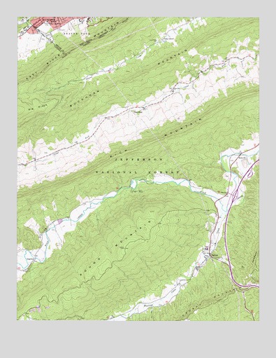
Bastian, VA USGS Topographic Map
Click on map above to begin viewing in our Map Viewer.

This topographic map contains these locations and features:
Feature Name Type Latitude Longitude GNIS ID View Map
BastianPopulated PlaceN37.1521°W81.1501°1492520View Map
Bastian Post OfficePost OfficeN37.1522°W81.1521°2766154View Map
Big RidgeRidgeN37.2115°W81.2493°1487034View Map
Bishops Chapel (historical)ChurchN37.2132°W81.1932°1494612View Map
Bland CountyCivilN37.1340°W81.1302°1494613View Map
Bluefield City ParkParkN37.2483°W81.2474°1481875View Map
Bluefield CollegeSchoolN37.2446°W81.2462°1481876View Map
Bluefield Country ClubLocaleN37.2482°W81.2345°1557130View Map
Bluefield Elks Club Golf CourseLocaleN37.2457°W81.2361°2634109View Map
Bluefield High SchoolSchoolN37.2486°W81.2178°1557133View Map
Bluefield Intermediate SchoolSchoolN37.2427°W81.2287°2088134View Map
Bowen FieldParkN37.2479°W81.2490°1481948View Map
Bowen FieldLocaleN37.2476°W81.2490°2726786View Map
ByronPopulated PlaceN37.2337°W81.1365°1494618View Map
Camp LaurelLocaleN37.2410°W81.1748°1482263View Map
Camp RolandLocaleN37.1785°W81.1890°1482273View Map
Clear ForkPopulated PlaceN37.2121°W81.1873°1492776View Map
Clear Fork ChurchChurchN37.2204°W81.1690°1482566View Map
District 4CivilN37.2235°W81.1414°1952419View Map
Dublin Police DepartmentBuildingN37.1794°W81.1475°2086042View Map
Ethan Allen Fire BrigadeBuildingN37.1508°W81.1561°2086035View Map
Fox BranchStreamN37.1512°W81.2462°1483512View Map
GrapefieldPopulated PlaceN37.1496°W81.2420°1493014View Map
Grapefield Volunteer Fire DepartmentBuildingN37.1529°W81.2383°2075544View Map
Green Valley ChurchChurchN37.1462°W81.2451°1483813View Map
HicksvillePopulated PlaceN37.1932°W81.1348°1493080View Map
Humana Hospital-Saint LukesHospitalN37.2426°W81.2311°2634715View Map
Hunting Camp CreekStreamN37.1701°W81.1423°1484287View Map
Interchange 58CrossingN37.1765°W81.1373°1494635View Map
Jefferson National ForestForestN37.1588°W81.1279°1851855View Map
Laurel Fork ChurchChurchN37.2407°W81.1776°1484705View Map
Lynn Hollow BranchStreamN37.1907°W81.2407°1494644View Map
Pine Grove ChurchChurchN37.1771°W81.1409°1486212View Map
Rocky Gap District (historical)CivilN37.2221°W81.1629°1927474View Map
Roof BranchStreamN37.1912°W81.1448°1494656View Map
Rose Hill CemeteryCemeteryN37.1629°W81.1484°1486768View Map
Round MountainSummitN37.1548°W81.1943°1486790View Map
Saint Luke's HospitalHospitalN37.2443°W81.2309°1558413View Map
Saint Luke's HospitalHospitalN37.2427°W81.2311°1558417View Map
Stowers Mill (historical)LocaleN37.1890°W81.2457°1494659View Map
StowersvillePopulated PlaceN37.1912°W81.2401°1494660View Map
Stowersville School (historical)SchoolN37.1910°W81.2407°1494661View Map
Sunny Point Church (historical)ChurchN37.2329°W81.1415°1494664View Map
Sunny Point School (historical)SchoolN37.2323°W81.1420°1494665View Map
Westgate Shopping CenterLocaleN37.2437°W81.2407°1497761View Map
White Creek Picnic AreaLocaleN37.1798°W81.1948°1488685View Map
Whitethorn Elementary SchoolSchoolN37.2498°W81.2306°1557360View Map

Note: Coordinates in the location and feature list above are referenced to NAD83 datum.


Copyright (C) 2008-2024 Ryan Niemi / Sunset Dynamics ... All Rights Reserved