TopoQuest Logo
Do you find TopoQuest useful?
Help keep TopoQuest running and adding new maps/features by donating!
Bitcoin:  19c7KJd3qBynnjoSw5npx9KScwjBe4ifkT
Litecoin:  LXs6TkuXGGXo1vDsWCkWVdjQX94eUKd6ui
Home View Maps Find Maps Find Places Resources & Links


Big Bend, Virginia Topographic Map

USGS Map Title: Big Bend, VA
USGS Map MRC: 37081A2
DRG (GeoTIFF) Download: o37081a2.tif


Neighboring USGS Topographic Map Quads:


  Cove Creek, VA  
37081B3
 

  Bastian, VA  
37081B2
 

  Rocky Gap, VA  
37081B1
 

  Garden Mountain, VA  
37081A3
 

  Big Bend, VA  
37081A2
 

  Bland, VA  
37081A1
 

  Rural Retreat, VA  
36081H3
 

  Crockett, VA  
36081H2
 

  Wytheville, VA  
36081H1


Map MRC Location:

N38°
W82°
N38°
W81°
H8 H7 H6 H5 H4 H3 H2 H1
G8 G7 G6 G5 G4 G3 G2 G1
F8 F7 F6 F5 F4 F3 F2 F1
E8 E7 E6 E5 E4 E3 E2 E1
D8 D7 D6 D5 D4 D3 D2 D1
C8 C7 C6 C5 C4 C3 C2 C1
B8 B7 B6 B5 B4 B3 B2 B1
A8 A7 A6 A5 A4 A3 A2 A1
N37°
W82°
N37°
W81°

Big Bend, VA USGS 1:24K Topographic Map Preview:
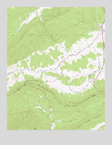
Big Bend, VA USGS Topographic Map
Click on map above to begin viewing in our Map Viewer.

This topographic map contains these locations and features:
Feature Name Type Latitude Longitude GNIS ID View Map
Bethel CemeteryCemeteryN37.0612°W81.2209°1481656View Map
Big BendBendN37.0254°W81.1776°1481694View Map
Big Bend Picnic AreaLocaleN37.0243°W81.1762°1488655View Map
Big Walker Mountain TunnelTunnelN37.0387°W81.1306°1494611View Map
Crab Orchard Creek DamDamN37.1068°W81.1331°1489249View Map
Crab Orchard LakeReservoirN37.1057°W81.1355°1494621View Map
Dear Trail Park CampgroundLocaleN37.0221°W81.2082°1488649View Map
Eagle OakPopulated PlaceN37.0515°W81.1882°1494626View Map
East Fork Stony ForkStreamN37.0082°W81.1901°1483212View Map
EffnaPopulated PlaceN37.0587°W81.2437°1483251View Map
Green Hill ChurchChurchN37.0562°W81.1415°1483802View Map
Greenhill School (historical)SchoolN37.0557°W81.1423°1494629View Map
Griffith KnobSummitN37.0012°W81.2154°1483837View Map
Hunting Camp Creek WildernessReserveN37.0922°W81.2465°2767371View Map
Hunting Camp DamDamN37.1035°W81.2348°1489248View Map
Interchange 52CrossingN37.1012°W81.1287°1494634View Map
Laurel CreekStreamN37.1240°W81.2079°1484689View Map
Liberty ChurchChurchN37.0576°W81.2462°1484791View Map
Liberty School (historical)SchoolN37.0576°W81.2465°1494639View Map
Little Walker MountainSummitN37.0010°W81.1618°1485001View Map
Little Wolf CreekStreamN37.1010°W81.2020°1485007View Map
Newberry CemeteryCemeteryN37.0721°W81.1326°1494647View Map
Original Stony Fork ChurchChurchN37.0251°W81.2093°1485991View Map
Robinetts Store (historical)LocaleN37.0765°W81.1629°1494655View Map
Stony Fork CampgroundLocaleN37.0090°W81.1826°1488656View Map
Stony Fork ChurchChurchN37.0215°W81.2037°1487622View Map
SuiterPopulated PlaceN37.1198°W81.2134°1493671View Map
Suiter School (historical)SchoolN37.1185°W81.2207°1494662View Map
SuitorLocaleN37.0265°W81.1948°1501371View Map
Trinity ChurchChurchN37.0623°W81.1870°1487986View Map
Walker MountainRidgeN37.0454°W81.2290°1488161View Map
Walker Mountain LookoutLocaleN37.0457°W81.2284°1488648View Map
Walker Mountain TrailTrailN37.0240°W81.1754°1488641View Map

Note: Coordinates in the location and feature list above are referenced to NAD83 datum.


Copyright (C) 2008-2025 Ryan Niemi / Sunset Dynamics ... All Rights Reserved