TopoQuest Logo
Do you find TopoQuest useful?
Help keep TopoQuest running and adding new maps/features by donating!
Bitcoin:  19c7KJd3qBynnjoSw5npx9KScwjBe4ifkT
Litecoin:  LXs6TkuXGGXo1vDsWCkWVdjQX94eUKd6ui
Home View Maps Find Maps Find Places Resources & Links


Garden Valley, Oregon Topographic Map

USGS Map Title: Garden Valley, OR
USGS Map MRC: 43123C4
DRG (GeoTIFF) Download: o43123c4.tif


Neighboring USGS Topographic Map Quads:


  Tyee, OR  
43123D5
 

  Tyee Mountain, OR  
43123D4
 

  Sutherlin, OR  
43123D3
 

  Callahan, OR  
43123C5
 

  Garden Valley, OR  
43123C4
 

  Winchester, OR  
43123C3
 

  Reston, OR  
43123B5
 

  Roseburg West, OR  
43123B4
 

  Roseburg East, OR  
43123B3


Map MRC Location:

N44°
W124°
N44°
W123°
H8 H7 H6 H5 H4 H3 H2 H1
G8 G7 G6 G5 G4 G3 G2 G1
F8 F7 F6 F5 F4 F3 F2 F1
E8 E7 E6 E5 E4 E3 E2 E1
D8 D7 D6 D5 D4 D3 D2 D1
C8 C7 C6 C5 C4 C3 C2 C1
B8 B7 B6 B5 B4 B3 B2 B1
A8 A7 A6 A5 A4 A3 A2 A1
N43°
W124°
N43°
W123°

Garden Valley, OR USGS 1:24K Topographic Map Preview:
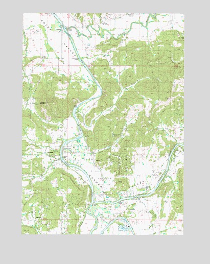
Garden Valley, OR USGS Topographic Map
Click on map above to begin viewing in our Map Viewer.

This topographic map contains these locations and features:
Feature Name Type Latitude Longitude GNIS ID View Map
Archambeaux Family CemeteryCemeteryN43.2598°W123.4561°1156883View Map
Browns BridgeBridgeN43.2715°W123.4117°1118135View Map
Burke CreekStreamN43.3637°W123.4429°1132988View Map
Burkhart RapidsRapidsN43.2682°W123.4326°1162533View Map
Calapooya CreekStreamN43.3659°W123.4662°1118457View Map
Champagne CreekStreamN43.2621°W123.4512°1118809View Map
Champagne Creek ValleyValleyN43.2609°W123.4512°1132956View Map
Champaigne Family CemeteryCemeteryN43.2511°W123.4570°1156882View Map
ClevelandPopulated PlaceN43.2962°W123.4765°1119014View Map
Cleveland CemeteryCemeteryN43.2950°W123.4765°1132984View Map
Cleveland HillSummitN43.2737°W123.4547°1136157View Map
Cleveland Post Office (historical)Post OfficeN43.2962°W123.4765°1165061View Map
Cleveland RapidsRapidsN43.2928°W123.4703°1132987View Map
Cleveland Rapids County Park Boat RampLocaleN43.2984°W123.4699°2668265View Map
Coles Valley CemeteryCemeteryN43.3495°W123.4868°1119158View Map
Coles Valley CreekStreamN43.3401°W123.4984°1132727View Map
Coyote HillSummitN43.2798°W123.4234°1136186View Map
Crow RapidsRapidsN43.3215°W123.4588°1134232View Map
Doerner ReservoirReservoirN43.2959°W123.4840°1162713View Map
Douglas County Fire District 2BuildingN43.3637°W123.4715°2576934View Map
Douglas County Fire District 2 Station 5BuildingN43.2833°W123.4115°2576933View Map
Eden CemeteryCemeteryN43.2564°W123.4877°1132981View Map
ElgarosePopulated PlaceN43.2582°W123.4859°1136249View Map
Elgarose Post Office (historical)Post OfficeN43.2582°W123.4859°1165201View Map
French Settlement Post Office (historical)Post OfficeN43.2629°W123.4509°1164372View Map
Garden ValleyValleyN43.3046°W123.4565°1121058View Map
Garden Valley School (historical)SchoolN43.2801°W123.4365°1121059View Map
Harmon Airport (historical)AirportN43.2812°W123.4123°1638874View Map
Hestness Landing County Park Boat RampLocaleN43.2837°W123.3916°2668321View Map
Hestness ParkParkN43.2846°W123.3915°1132982View Map
Hidden Valley CreekStreamN43.3040°W123.4567°1132985View Map
Hidden Valley ReservoirReservoirN43.3057°W123.4306°1134233View Map
La Brie Family CemeteriesCemeteryN43.2796°W123.4529°1162714View Map
Laraut Post Office (historical)Post OfficeN43.2832°W123.4512°1164457View Map
Melrose Census Designated PlaceCensusN43.2529°W123.4575°2611755View Map
North Umpqua RiverStreamN43.2682°W123.4459°1147070View Map
Pitchford Boys RanchSchoolN43.2712°W123.4401°1638876View Map
Red HillSummitN43.2918°W123.4399°1136673View Map
River Forks County ParkParkN43.2693°W123.4456°1132983View Map
River Forks County Park Boat RampLocaleN43.2723°W123.4458°2668404View Map
RiversdalePopulated PlaceN43.2654°W123.4215°1136688View Map
Singleton ParkParkN43.2668°W123.4459°1127000View Map
South Umpqua RiverStreamN43.2679°W123.4462°1150090View Map
Sutherlin CreekStreamN43.3009°W123.3762°1127773View Map
Twin Rivers CampgroundLocaleN43.2698°W123.4359°1638875View Map
UmpquaPopulated PlaceN43.3654°W123.4684°1128405View Map
Umpqua Basin Water Association Water Treatment PlantLocaleN43.2702°W123.4107°2660765View Map
Umpqua LandingLocaleN43.3665°W123.4679°1134231View Map
Umpqua Landing County Park Boat RampLocaleN43.3663°W123.4682°2668499View Map
Umpqua Post OfficePost OfficeN43.3672°W123.4550°1166081View Map
Willow CreekStreamN43.2546°W123.4904°1162800View Map
Winniford Post Office (historical)Post OfficeN43.3207°W123.4498°1166201View Map
Woodruff MountainSummitN43.3238°W123.4826°1129312View Map

Note: Coordinates in the location and feature list above are referenced to NAD83 datum.


Copyright (C) 2008-2025 Ryan Niemi / Sunset Dynamics ... All Rights Reserved