TopoQuest Logo
Do you find TopoQuest useful?
Help keep TopoQuest running and adding new maps/features by donating!
Bitcoin:  19c7KJd3qBynnjoSw5npx9KScwjBe4ifkT
Litecoin:  LXs6TkuXGGXo1vDsWCkWVdjQX94eUKd6ui
Home View Maps Find Maps Find Places Resources & Links


Garfield, Colorado Topographic Map

USGS Map Title: Garfield, CO
USGS Map MRC: 38106E3
DRG (GeoTIFF) Download: o38106e3.tif


Neighboring USGS Topographic Map Quads:


  Cumberland Pass, CO  
38106F4
 

  Saint Elmo, CO  
38106F3
 

  Mount Antero, CO  
38106F2
 

  Whitepine, CO  
38106E4
 

  Garfield, CO  
38106E3
 

  Maysville, CO  
38106E2
 

  Sargents, CO  
38106D4
 

  Pahlone Peak, CO  
38106D3
 

  Mount Ouray, CO  
38106D2


Map MRC Location:

N39°
W107°
N39°
W106°
H8 H7 H6 H5 H4 H3 H2 H1
G8 G7 G6 G5 G4 G3 G2 G1
F8 F7 F6 F5 F4 F3 F2 F1
E8 E7 E6 E5 E4 E3 E2 E1
D8 D7 D6 D5 D4 D3 D2 D1
C8 C7 C6 C5 C4 C3 C2 C1
B8 B7 B6 B5 B4 B3 B2 B1
A8 A7 A6 A5 A4 A3 A2 A1
N38°
W107°
N38°
W106°

Garfield, CO USGS 1:24K Topographic Map Preview:
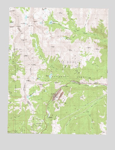
Garfield, CO USGS Topographic Map
Click on map above to begin viewing in our Map Viewer.

This topographic map contains these locations and features:
Feature Name Type Latitude Longitude GNIS ID View Map
Alaska MineMineN38.5592°W106.2770°1745727View Map
Alpha and Beta MineMineN38.5656°W106.2970°1745728View Map
Anna Huffman Copper MineMineN38.5017°W106.2509°1745730View Map
April Fool MineMineN38.5403°W106.2956°1745731View Map
Bald MountainSummitN38.5531°W106.3497°189382View Map
Banana MountainSummitN38.5489°W106.3350°189384View Map
Ben Bolts Paymaster MineMineN38.5500°W106.3172°1745732View Map
Billings LakeLakeN38.6230°W106.3299°189351View Map
Black Tiger MineMineN38.5497°W106.2895°1745734View Map
Bonnie Belle MineMineN38.5731°W106.2895°1745735View Map
Boss Lake DamDamN38.5567°W106.3206°201544View Map
Boss Lake ReservoirReservoirN38.5573°W106.3221°201545View Map
Brighton MineMineN38.5844°W106.2972°1745736View Map
Brittle Silver MountainSummitN38.6056°W106.3736°189345View Map
Burton QuarryMineN38.5500°W106.3172°1745737View Map
Calico MountainSummitN38.6208°W106.3047°189302View Map
Chalk Creek PassGapN38.6064°W106.3506°189309View Map
Clinton MineMineN38.5931°W106.2797°1745724View Map
Clover MountainSummitN38.5678°W106.3467°189373View Map
Columbus GulchValleyN38.5619°W106.3061°189313View Map
Columbus MineMineN38.5719°W106.3286°1745739View Map
Contact HillSummitN38.5519°W106.3695°189381View Map
Cyclone CreekStreamN38.6019°W106.2897°189353View Map
Darling MineMineN38.5731°W106.2975°1745740View Map
Deer GulchValleyN38.5767°W106.3699°189374View Map
Delaware MineMineN38.5500°W106.3172°1745741View Map
Desdemona MineMineN38.5694°W106.2953°1745742View Map
Eclipse MineMineN38.5347°W106.3134°1745743View Map
Elkington MineMineN38.5411°W106.3009°1745744View Map
Evening Star MineMineN38.5408°W106.2914°1745746View Map
Fairplay MineMineN38.5556°W106.3122°1745747View Map
Flora Belle MineMineN38.5003°W106.2509°1745749View Map
Fooses Creek TrailTrailN38.5069°W106.2697°203388View Map
Fort Scott GulchValleyN38.5795°W106.3715°189375View Map
Fraction MineMineN38.5750°W106.2853°1745751View Map
French QuarryMineN38.5500°W106.3172°1745752View Map
GarfieldPopulated PlaceN38.5517°W106.2922°204757View Map
Garfield CampgroundLocaleN38.5472°W106.3036°196855View Map
Garfield Census Designated PlaceCensusN38.5493°W106.2893°2583238View Map
Garfield MineMineN38.5611°W106.2867°189362View Map
Giant Eclipse MineMineN38.5500°W106.2839°1745754View Map
Golden Age MineMineN38.5717°W106.2978°1745755View Map
Grand Monarch MineMineN38.5500°W106.3172°1763871View Map
Great Monarch MineMineN38.5408°W106.3047°1745756View Map
Half Moon MineMineN38.5711°W106.3286°1745757View Map
Hancock LakeLakeN38.6151°W106.3539°189342View Map
Hancock PassGapN38.6208°W106.3742°189348View Map
Hawkeye Number One MineMineN38.5242°W106.3153°1745758View Map
Hawkeye Number Three MineMineN38.5289°W106.3153°1745760View Map
Hawkeye Number Two MineMineN38.5242°W106.3211°1745759View Map
Hermit SpringsSpringN38.5558°W106.2742°196847View Map
Hoffman ParkFlatN38.5756°W106.3111°189359View Map
Hunkydory GulchValleyN38.6008°W106.2887°189354View Map
Hunkydory LakeLakeN38.5953°W106.3049°196853View Map
Hunt LakeLakeN38.5544°W106.3362°189383View Map
Indianapolis MineMineN38.5758°W106.2909°1745762View Map
Irishwood Esther MineMineN38.6000°W106.3006°1745763View Map
Iron Duke MineMineN38.5767°W106.2931°1745764View Map
Island LakeLakeN38.6098°W106.3354°196852View Map
Jennings CreekStreamN38.5997°W106.2778°189355View Map
Jewell Tunnel MineMineN38.5642°W106.2975°1735432View Map
Josephine Number One QuarryMineN38.5003°W106.3339°1745765View Map
Kangaroo GulchValleyN38.5617°W106.3050°189360View Map
Lake HillSummitN38.5306°W106.3739°189393View Map
Last Chance MineMineN38.5731°W106.2909°1745766View Map
Lilly MineMineN38.5697°W106.2867°1745768View Map
Lily MineMineN38.5694°W106.2867°189411View Map
Little Charm MineMineN38.6075°W106.3050°1745769View Map
Little Wonder MineMineN38.5369°W106.3153°1745770View Map
Lost MountainSummitN38.5847°W106.2645°189300View Map
Madonna MineMineN38.5294°W106.3072°1745726View Map
Major MineMineN38.5683°W106.2839°1745772View Map
Mason MineMineN38.5878°W106.3520°1735879View Map
McCoy CreekStreamN38.5922°W106.2506°189314View Map
Middle Fork South Arkansas RiverStreamN38.5508°W106.2928°189357View Map
Missouri Boy MineMineN38.5678°W106.2806°1745776View Map
Missouri HillSummitN38.5850°W106.2750°189299View Map
Monarch (historical)LocaleN38.5406°W106.3142°203903View Map
Monarch Lime QuarryMineN38.5389°W106.3089°1745725View Map
Monarch Park CampgroundLocaleN38.5156°W106.3247°196858View Map
Monarch Ski AreaLocaleN38.5103°W106.3395°196857View Map
Monongahela MineMineN38.5500°W106.3172°1763872View Map
Monumental PeakSummitN38.5925°W106.3578°189311View Map
Moss Flower MineMineN38.5711°W106.3286°1745777View Map
Mount AetnaSummitN38.5858°W106.3200°189297View Map
Mountain Chief MineMineN38.5761°W106.2889°1763873View Map
New York MineMineN38.5753°W106.2897°1745778View Map
North Fooses CreekStreamN38.5239°W106.2709°189369View Map
North Fork CampgroundLocaleN38.6119°W106.3200°196854View Map
North Fork DamDamN38.6089°W106.3253°199004View Map
North Fork ReservoirReservoirN38.6102°W106.3229°196851View Map
Ohio and Morningstar MineMineN38.5500°W106.3172°1745779View Map
Original Monarch PassGapN38.5114°W106.3470°1675537View Map
Oshkosh MineMineN38.5400°W106.3111°1745781View Map
Page MineMineN38.5697°W106.2917°1745782View Map
Paymaster MineMineN38.5333°W106.3056°1745783View Map
Pilgrim Group MineMineN38.6000°W106.3006°1745784View Map
Pinyon MineMineN38.5750°W106.2878°1745785View Map
Rainbow-Eagle Bird MineMineN38.5750°W106.2878°1745738View Map
Robbins CreekStreamN38.5711°W106.3728°189377View Map
Sewanee PeakSummitN38.6111°W106.3450°189308View Map
Shamrock MineMineN38.5667°W106.2872°1745788View Map
Shavano (historical)Populated PlaceN38.6028°W106.2903°203902View Map
Silent Friend MineMineN38.5225°W106.3153°1745789View Map
Silver King MineMineN38.5711°W106.3286°1745790View Map
Song Bird MineMineN38.5778°W106.2867°1745791View Map
South Fooses CreekStreamN38.5239°W106.2709°189370View Map
South Quartz Creek MineMineN38.5661°W106.3517°1745812View Map
Syncline HillSummitN38.5506°W106.3159°189365View Map
Taylor GulchValleyN38.5509°W106.2883°189361View Map
Taylor MountainSummitN38.5831°W106.2992°189298View Map
Thirty-six-thirty MineMineN38.6233°W106.3150°1745794View Map
Tomichi CemeteryCemeteryN38.5714°W106.3703°189376View Map
Upper Hancock LakeLakeN38.6088°W106.3544°189343View Map
Van Wirt MountainSummitN38.6061°W106.3650°189344View Map
Vulcan MountainSummitN38.5769°W106.3511°189372View Map
Waterdog LakesLakeN38.5375°W106.3450°189385View Map
Wilson MineMineN38.5311°W106.3078°1745796View Map

Note: Coordinates in the location and feature list above are referenced to NAD83 datum.


Copyright (C) 2008-2025 Ryan Niemi / Sunset Dynamics ... All Rights Reserved