TopoQuest Logo
Do you find TopoQuest useful?
Help keep TopoQuest running and adding new maps/features by donating!
Bitcoin:  19c7KJd3qBynnjoSw5npx9KScwjBe4ifkT
Litecoin:  LXs6TkuXGGXo1vDsWCkWVdjQX94eUKd6ui
Home View Maps Find Maps Find Places Resources & Links


Sargents, Colorado Topographic Map

USGS Map Title: Sargents, CO
USGS Map MRC: 38106D4
DRG (GeoTIFF) Download: o38106d4.tif


Neighboring USGS Topographic Map Quads:


  Pitkin, CO  
38106E5
 

  Whitepine, CO  
38106E4
 

  Garfield, CO  
38106E3
 

  Doyleville, CO  
38106D5
 

  Sargents, CO  
38106D4
 

  Pahlone Peak, CO  
38106D3
 

  West Baldy, CO  
38106C5
 

  Sargents Mesa, CO  
38106C4
 

  Chester, CO  
38106C3


Map MRC Location:

N39°
W107°
N39°
W106°
H8 H7 H6 H5 H4 H3 H2 H1
G8 G7 G6 G5 G4 G3 G2 G1
F8 F7 F6 F5 F4 F3 F2 F1
E8 E7 E6 E5 E4 E3 E2 E1
D8 D7 D6 D5 D4 D3 D2 D1
C8 C7 C6 C5 C4 C3 C2 C1
B8 B7 B6 B5 B4 B3 B2 B1
A8 A7 A6 A5 A4 A3 A2 A1
N38°
W107°
N38°
W106°

Sargents, CO USGS 1:24K Topographic Map Preview:
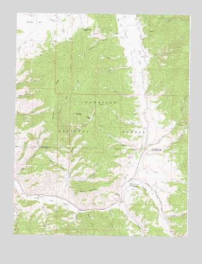
Sargents, CO USGS Topographic Map
Click on map above to begin viewing in our Map Viewer.

This topographic map contains these locations and features:
Feature Name Type Latitude Longitude GNIS ID View Map
Agate CampgroundLocaleN38.4383°W106.3825°189706View Map
Agate CreekStreamN38.4228°W106.4109°189707View Map
Black Sage PassGapN38.4906°W106.4517°189686View Map
Brier CreekStreamN38.4350°W106.3761°189705View Map
Brush CreekStreamN38.4133°W106.4128°189708View Map
Calf CreekStreamN38.4706°W106.4114°189689View Map
Carlson CreekStreamN38.4003°W106.4014°189710View Map
Cow CreekStreamN38.4078°W106.4556°189690View Map
Cow GulchValleyN38.4373°W106.4082°189703View Map
Daly GulchValleyN38.4230°W106.4127°189704View Map
Dawson CreekStreamN38.3950°W106.4645°189698View Map
Dawson ParkFlatN38.4417°W106.4450°189695View Map
Dawson RidgeRidgeN38.4667°W106.4634°189692View Map
Deadman GulchValleyN38.3883°W106.4478°197479View Map
Hicks CreekStreamN38.3939°W106.4775°189715View Map
Hicks GulchValleyN38.4071°W106.4995°189702View Map
Left Hand Dawson CreekStreamN38.4311°W106.4600°189697View Map
Long BranchStreamN38.3939°W106.4225°189712View Map
Major CreekStreamN38.4808°W106.4128°189368View Map
Marshall CreekStreamN38.4033°W106.4220°189716View Map
Means CreekStreamN38.4711°W106.4128°189688View Map
Mountain Spring CreekStreamN38.4822°W106.4186°189687View Map
Nelson CreekStreamN38.3856°W106.3928°189711View Map
No Name CreekStreamN38.4689°W106.4111°189367View Map
Porphyry CreekStreamN38.4708°W106.4106°189693View Map
Quakey MountainSummitN38.4436°W106.4567°189694View Map
Quakey Mountain TrailTrailN38.4678°W106.4609°189691View Map
Right Hand Dawson CreekStreamN38.4311°W106.4600°189696View Map
SargentsPopulated PlaceN38.4042°W106.4150°204762View Map
Sargents Fire DepartmentBuildingN38.4033°W106.4165°2667272View Map
Sargents Post OfficePost OfficeN38.4044°W106.4147°2750903View Map
Sawmill GulchValleyN38.4047°W106.4616°189701View Map
Steepy MountainSummitN38.4006°W106.4411°189700View Map
Swag GulchValleyN38.4123°W106.4618°189699View Map
Templeton CreekStreamN38.3883°W106.4528°189714View Map
Tomichi Picnic AreaLocaleN38.3881°W106.4473°197480View Map
Triano CreekStreamN38.4914°W106.4236°189366View Map
Waunita ParkFlatN38.4947°W106.4870°203383View Map
Weddle CreekStreamN38.3908°W106.4323°189713View Map

Note: Coordinates in the location and feature list above are referenced to NAD83 datum.


Copyright (C) 2008-2024 Ryan Niemi / Sunset Dynamics ... All Rights Reserved