TopoQuest Logo
Do you find TopoQuest useful?
Help keep TopoQuest running and adding new maps/features by donating!
Bitcoin:  19c7KJd3qBynnjoSw5npx9KScwjBe4ifkT
Litecoin:  LXs6TkuXGGXo1vDsWCkWVdjQX94eUKd6ui
Home View Maps Find Maps Find Places Resources & Links


Adamsville, Utah Topographic Map

USGS Map Title: Adamsville, UT
USGS Map MRC: 38112C7
DRG (GeoTIFF) Download: o38112c7.tif


Neighboring USGS Topographic Map Quads:


  Ranch Canyon, UT  
38112D8
 

  Bearskin Mountain, UT  
38112D7
 

  Gillies Hill, UT  
38112D6
 

  Cave Canyon, UT  
38112C8
 

  Adamsville, UT  
38112C7
 

  Beaver, UT  
38112C6
 

  Minersville, UT  
38112B8
 

  Minersville Reservoir, UT  
38112B7
 

  Greenville Bench, UT  
38112B6


Map MRC Location:

N39°
W113°
N39°
W112°
H8 H7 H6 H5 H4 H3 H2 H1
G8 G7 G6 G5 G4 G3 G2 G1
F8 F7 F6 F5 F4 F3 F2 F1
E8 E7 E6 E5 E4 E3 E2 E1
D8 D7 D6 D5 D4 D3 D2 D1
C8 C7 C6 C5 C4 C3 C2 C1
B8 B7 B6 B5 B4 B3 B2 B1
A8 A7 A6 A5 A4 A3 A2 A1
N38°
W113°
N38°
W112°

Adamsville, UT USGS 1:24K Topographic Map Preview:
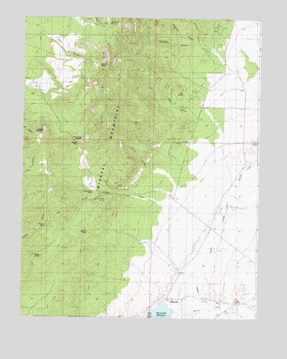
Adamsville, UT USGS Topographic Map
Click on map above to begin viewing in our Map Viewer.

This topographic map contains these locations and features:
Feature Name Type Latitude Longitude GNIS ID View Map
AdamsvillePopulated PlaceN38.2583°W112.7938°1425050View Map
Adamsville CemeteryCemeteryN38.2595°W112.7836°2083244View Map
Bartons HollowValleyN38.3127°W112.8105°1425308View Map
Beaumont CanyonValleyN38.3669°W112.7897°1425373View Map
Beaver View MineMineN38.3297°W112.7913°1425388View Map
Blue Star MineMineN38.3055°W112.8255°1425827View Map
Cherry CreekStreamN38.2839°W112.7799°1426557View Map
Cherry Creek SpringSpringN38.3030°W112.8382°1426560View Map
Cow HollowValleyN38.3666°W112.8600°1427006View Map
Dripping SpringSpringN38.2760°W112.8687°1427487View Map
Furnace DitchCanalN38.2586°W112.7797°1428115View Map
Granite CanyonValleyN38.3011°W112.8380°1428315View Map
Granite Peak ReservoirReservoirN38.3244°W112.8439°1428326View Map
Granite SpringSpringN38.2997°W112.8343°1428332View Map
Harkley MountainSummitN38.3272°W112.8661°1428535View Map
Indian CreekStreamN38.2527°W112.7941°1441986View Map
Limestone SpringSpringN38.2858°W112.8405°1429638View Map
McEwen SpringSpringN38.3553°W112.8350°1430175View Map
Mineral MountainsRangeN38.3650°W112.8202°1430365View Map
Mud SpringSpringN38.3434°W112.7911°1430561View Map
Pole Line SpringSpringN38.2878°W112.8626°1431388View Map
Porcupine CanyonValleyN38.3686°W112.7833°1431411View Map
Rock CorralLocaleN38.3719°W112.8349°1431905View Map
Rock Corral Recreation SiteParkN38.3725°W112.8333°1450483View Map
Rock Corral SpringSpringN38.3728°W112.8297°1431907View Map
Shag HollowValleyN38.3344°W112.7872°1432351View Map
Soldier PassGapN38.3225°W112.8477°1432624View Map
Solomons HollowValleyN38.3644°W112.7869°1432627View Map
Wildcat CreekStreamN38.3022°W112.7641°1447355View Map

Note: Coordinates in the location and feature list above are referenced to NAD83 datum.


Copyright (C) 2008-2025 Ryan Niemi / Sunset Dynamics ... All Rights Reserved