TopoQuest Logo
Do you find TopoQuest useful?
Help keep TopoQuest running and adding new maps/features by donating!
Bitcoin:  19c7KJd3qBynnjoSw5npx9KScwjBe4ifkT
Litecoin:  LXs6TkuXGGXo1vDsWCkWVdjQX94eUKd6ui
Home View Maps Find Maps Find Places Resources & Links


Gaskin, Florida Topographic Map

USGS Map Title: Gaskin, FL
USGS Map MRC: 30086H2
DRG (GeoTIFF) Download: o30086h2.tif


Neighboring USGS Topographic Map Quads:


  Florala, AL  
31086A3
 

  Hacoda, AL  
31086A2
 

  Samson, AL  
31086A1
 

  Paxton, FL  
30086H3
 

  Gaskin, FL  
30086H2
 

  Darlington, FL  
30086H1
 

  New Harmony, FL  
30086G3
 

  Liberty, FL  
30086G2
 

  Glendale, FL  
30086G1


Map MRC Location:

N31°
W87°
N31°
W86°
H8 H7 H6 H5 H4 H3 H2 H1
G8 G7 G6 G5 G4 G3 G2 G1
F8 F7 F6 F5 F4 F3 F2 F1
E8 E7 E6 E5 E4 E3 E2 E1
D8 D7 D6 D5 D4 D3 D2 D1
C8 C7 C6 C5 C4 C3 C2 C1
B8 B7 B6 B5 B4 B3 B2 B1
A8 A7 A6 A5 A4 A3 A2 A1
N30°
W87°
N30°
W86°

Gaskin, FL USGS 1:24K Topographic Map Preview:
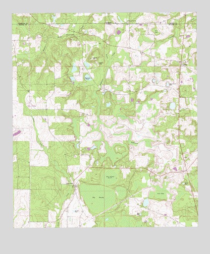
Gaskin, FL USGS Topographic Map
Click on map above to begin viewing in our Map Viewer.

This topographic map contains these locations and features:
Feature Name Type Latitude Longitude GNIS ID View Map
Adams PondLakeN30.9707°W86.1908°277683View Map
Bell PondLakeN30.8825°W86.1638°278427View Map
Big SwampSwampN30.8928°W86.1928°278758View Map
Big Swamp AnnexSwampN30.9042°W86.1846°278759View Map
Bunge Farm Airport (historical)AirportN30.8796°W86.2086°309365View Map
Caney CreekPopulated PlaceN30.8999°W86.2086°295174View Map
Cat PondLakeN30.8783°W86.1593°280135View Map
Center PondLakeN30.9002°W86.1346°280242View Map
Danley HillSummitN30.9735°W86.1955°281290View Map
Deurell PondLakeN30.8848°W86.2089°281520View Map
Dry BranchStreamN30.9713°W86.1836°281785View Map
E H Myers PondLakeN30.8894°W86.1600°298140View Map
Eightmile Creek ChurchChurchN30.9946°W86.1733°117893View Map
GaskinPopulated PlaceN30.9710°W86.1355°282957View Map
Jack BaySwampN30.8950°W86.1507°284648View Map
Jackson Still TowerTowerN30.8999°W86.2074°301691View Map
Manning PondLakeN30.9623°W86.1987°286388View Map
Melanie's AirportAirportN30.9197°W86.2178°2717009View Map
Natural BridgeArchN30.9866°W86.2122°287550View Map
Paxton-Darlington DivisionCivilN30.8783°W86.2245°1935892View Map
Punch Bowl PondLakeN30.9581°W86.1448°289375View Map
Red BaySwampN30.9891°W86.1527°289531View Map
Walton County Fire Rescue Station 3 Dalington - Gaskin Fire RescueBuildingN30.9705°W86.1348°2644208View Map

Note: Coordinates in the location and feature list above are referenced to NAD83 datum.


Copyright (C) 2008-2024 Ryan Niemi / Sunset Dynamics ... All Rights Reserved