TopoQuest Logo
Do you find TopoQuest useful?
Help keep TopoQuest running and adding new maps/features by donating!
Bitcoin:  19c7KJd3qBynnjoSw5npx9KScwjBe4ifkT
Litecoin:  LXs6TkuXGGXo1vDsWCkWVdjQX94eUKd6ui
Home View Maps Find Maps Find Places Resources & Links


Darlington, Florida Topographic Map

USGS Map Title: Darlington, FL
USGS Map MRC: 30086H1
DRG (GeoTIFF) Download: o30086h1.tif


Neighboring USGS Topographic Map Quads:


  Hacoda, AL  
31086A2
 

  Samson, AL  
31086A1
 

  Geneva West, AL  
31085A8
 

  Gaskin, FL  
30086H2
 

  Darlington, FL  
30086H1
 

  Hobbs Crossroads, FL  
30085H8
 

  Liberty, FL  
30086G2
 

  Glendale, FL  
30086G1
 

  Prosperity, FL  
30085G8


Map MRC Location:

N31°
W87°
N31°
W86°
H8 H7 H6 H5 H4 H3 H2 H1
G8 G7 G6 G5 G4 G3 G2 G1
F8 F7 F6 F5 F4 F3 F2 F1
E8 E7 E6 E5 E4 E3 E2 E1
D8 D7 D6 D5 D4 D3 D2 D1
C8 C7 C6 C5 C4 C3 C2 C1
B8 B7 B6 B5 B4 B3 B2 B1
A8 A7 A6 A5 A4 A3 A2 A1
N30°
W87°
N30°
W86°

Darlington, FL USGS 1:24K Topographic Map Preview:
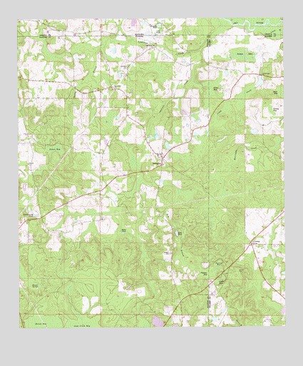
Darlington, FL USGS Topographic Map
Click on map above to begin viewing in our Map Viewer.

This topographic map contains these locations and features:
Feature Name Type Latitude Longitude GNIS ID View Map
Alder PondLakeN30.9131°W86.0507°277734View Map
Broxton CemeteryCemeteryN30.8980°W86.0216°279501View Map
Burgess PondLakeN30.9974°W86.0602°115225View Map
Burgess School (historical)SchoolN30.9949°W86.0527°132101View Map
Camp Creek ChurchChurchN30.9771°W86.0099°279892View Map
Chestnut CreekStreamN30.9880°W86.0380°280375View Map
Collinsworth PondLakeN30.9211°W86.1171°280667View Map
Cook PondLakeN30.9949°W86.0591°116533View Map
DarlingtonPopulated PlaceN30.9438°W86.0574°281297View Map
Darlington Gascon Fire StationBuildingN30.9437°W86.0571°2760212View Map
Dry BranchStreamN30.9482°W86.0724°281784View Map
Dukes BaySwampN30.9473°W86.1080°281848View Map
Ealum BaySwampN30.8760°W86.1169°281935View Map
Grassy BaySwampN30.9627°W86.0062°283309View Map
Green PondSwampN30.8937°W86.0314°283401View Map
Johnson LakesSwampN30.9085°W86.0155°592378View Map
Johnson LakesSwampN30.9852°W86.0177°284881View Map
LeoniaPopulated PlaceN30.9085°W86.0249°297500View Map
Leonia Baptist ChurchChurchN30.9082°W86.0147°1805744View Map
Leonia CemeteryCemeteryN30.9091°W86.0152°1805745View Map
Limestone CemeteryCemeteryN30.9796°W86.0741°285534View Map
Limestone ChurchChurchN30.9730°W86.0791°285535View Map
Limestone CreekStreamN30.9988°W86.0249°121645View Map
Mack BaySwampN30.9699°W86.0005°286258View Map
Miller PondLakeN30.9135°W86.0757°286922View Map
Oak Grove ChurchChurchN30.9891°W86.0602°287956View Map
Padgett CemeteryCemeteryN30.9049°W86.0538°288363View Map
Peavey BaySwampN30.9009°W86.0312°288645View Map
Pikehole BaySwampN30.8975°W86.0352°288811View Map
Porter BaySwampN30.9698°W86.0334°289243View Map
Spring BranchStreamN30.9916°W86.0791°291520View Map
Weaver SpringsSpringN30.8916°W86.1127°292968View Map

Note: Coordinates in the location and feature list above are referenced to NAD83 datum.


Copyright (C) 2008-2025 Ryan Niemi / Sunset Dynamics ... All Rights Reserved