TopoQuest Logo
Do you find TopoQuest useful?
Help keep TopoQuest running and adding new maps/features by donating!
Bitcoin:  19c7KJd3qBynnjoSw5npx9KScwjBe4ifkT
Litecoin:  LXs6TkuXGGXo1vDsWCkWVdjQX94eUKd6ui
Home View Maps Find Maps Find Places Resources & Links


Liberty, Florida Topographic Map

USGS Map Title: Liberty, FL
USGS Map MRC: 30086G2
DRG (GeoTIFF) Download: o30086g2.tif


Neighboring USGS Topographic Map Quads:


  Paxton, FL  
30086H3
 

  Gaskin, FL  
30086H2
 

  Darlington, FL  
30086H1
 

  New Harmony, FL  
30086G3
 

  Liberty, FL  
30086G2
 

  Glendale, FL  
30086G1
 

  Mossy Head, FL  
30086F3
 

  De Funiak Springs West, FL  
30086F2
 

  De Funiak Springs East, FL  
30086F1


Map MRC Location:

N31°
W87°
N31°
W86°
H8 H7 H6 H5 H4 H3 H2 H1
G8 G7 G6 G5 G4 G3 G2 G1
F8 F7 F6 F5 F4 F3 F2 F1
E8 E7 E6 E5 E4 E3 E2 E1
D8 D7 D6 D5 D4 D3 D2 D1
C8 C7 C6 C5 C4 C3 C2 C1
B8 B7 B6 B5 B4 B3 B2 B1
A8 A7 A6 A5 A4 A3 A2 A1
N30°
W87°
N30°
W86°

Liberty, FL USGS 1:24K Topographic Map Preview:
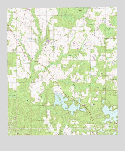
Liberty, FL USGS Topographic Map
Click on map above to begin viewing in our Map Viewer.

This topographic map contains these locations and features:
Feature Name Type Latitude Longitude GNIS ID View Map
Bear Pen IslandIslandN30.8738°W86.1658°278339View Map
Bee BranchStreamN30.8207°W86.2205°278377View Map
Bell Bay BranchStreamN30.7552°W86.1752°278413View Map
Big Swamp CreekStreamN30.7891°W86.2402°278760View Map
Buffalo LakeLakeN30.7838°W86.1684°279622View Map
Caney CreekStreamN30.8374°W86.2113°279979View Map
Cluster SpringsPopulated PlaceN30.8385°W86.2052°294717View Map
Cow BaySwampN30.8586°W86.1546°280914View Map
Cypress DrainsSwampN30.8671°W86.1830°281210View Map
Duck PuddleSwampN30.7963°W86.1445°281832View Map
EalumPopulated PlaceN30.8405°W86.2436°301687View Map
Gum CreekStreamN30.7891°W86.2402°283531View Map
Holly LakeReservoirN30.7764°W86.1750°284172View Map
Hubert Bell PondLakeN30.8283°W86.1501°298146View Map
Juniper BaySwampN30.8611°W86.1262°284985View Map
Juniper CreekStreamN30.8338°W86.1397°284990View Map
Juniper LakeReservoirN30.7704°W86.1303°284998View Map
Kings LakeReservoirN30.7834°W86.1895°285122View Map
Lake ChipleyLakeN30.7593°W86.1361°280400View Map
LibertyPopulated PlaceN30.8205°W86.2136°295406View Map
Liberty Volunteer Fire DepartmentBuildingN30.7947°W86.2002°2644307View Map
Long BranchStreamN30.8452°W86.2058°285966View Map
Middle CreekStreamN30.8080°W86.2224°286786View Map
Narrows CreekStreamN30.7807°W86.2141°287539View Map
Nowling Spring BranchStreamN30.7613°W86.1836°287908View Map
Piney GrovePopulated PlaceN30.8041°W86.1308°295545View Map
Pretty PondLakeN30.7796°W86.1537°289307View Map
R B UnderwoodLakeN30.7828°W86.1411°298150View Map
Raccoon Hollow BranchStreamN30.7728°W86.1972°2723434View Map
Sand HillPopulated PlaceN30.8371°W86.1905°301686View Map

Note: Coordinates in the location and feature list above are referenced to NAD83 datum.


Copyright (C) 2008-2024 Ryan Niemi / Sunset Dynamics ... All Rights Reserved