TopoQuest Logo
Do you find TopoQuest useful?
Help keep TopoQuest running and adding new maps/features by donating!
Bitcoin:  19c7KJd3qBynnjoSw5npx9KScwjBe4ifkT
Litecoin:  LXs6TkuXGGXo1vDsWCkWVdjQX94eUKd6ui
Home View Maps Find Maps Find Places Resources & Links


Glendale, Florida Topographic Map

USGS Map Title: Glendale, FL
USGS Map MRC: 30086G1
DRG (GeoTIFF) Download: o30086g1.tif


Neighboring USGS Topographic Map Quads:


  Gaskin, FL  
30086H2
 

  Darlington, FL  
30086H1
 

  Hobbs Crossroads, FL  
30085H8
 

  Liberty, FL  
30086G2
 

  Glendale, FL  
30086G1
 

  Prosperity, FL  
30085G8
 

  De Funiak Springs West, FL  
30086F2
 

  De Funiak Springs East, FL  
30086F1
 

  Ponce de Leon, FL  
30085F8


Map MRC Location:

N31°
W87°
N31°
W86°
H8 H7 H6 H5 H4 H3 H2 H1
G8 G7 G6 G5 G4 G3 G2 G1
F8 F7 F6 F5 F4 F3 F2 F1
E8 E7 E6 E5 E4 E3 E2 E1
D8 D7 D6 D5 D4 D3 D2 D1
C8 C7 C6 C5 C4 C3 C2 C1
B8 B7 B6 B5 B4 B3 B2 B1
A8 A7 A6 A5 A4 A3 A2 A1
N30°
W87°
N30°
W86°

Glendale, FL USGS 1:24K Topographic Map Preview:
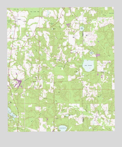
Glendale, FL USGS Topographic Map
Click on map above to begin viewing in our Map Viewer.

This topographic map contains these locations and features:
Feature Name Type Latitude Longitude GNIS ID View Map
Anderson BaySwampN30.8596°W86.0729°277852View Map
Anderson Mill CreekStreamN30.8096°W86.0591°277860View Map
Andrews Mill CreekStreamN30.7796°W86.0655°277876View Map
Bay BranchStreamN30.8524°W86.0611°278188View Map
Big BranchStreamN30.8046°W86.0974°278639View Map
Blue PondLakeN30.8537°W86.0378°279053View Map
Bridge CreekStreamN30.7532°W86.0080°279386View Map
Bridge Creek ChurchChurchN30.7652°W86.0219°279387View Map
Brim PondLakeN30.8453°W86.0454°279404View Map
Bull PondLakeN30.8467°W86.0304°279645View Map
Camp CreekStreamN30.8194°W86.0766°279889View Map
Center RidgePopulated PlaceN30.8027°W86.0947°301690View Map
Center Ridge ChurchChurchN30.7996°W86.0952°280243View Map
Double PondLakeN30.8290°W86.0267°281708View Map
Drake BaySwampN30.8156°W86.0637°281747View Map
Duval BranchStreamN30.8663°W86.0060°281896View Map
Friendship ChurchChurchN30.8044°W86.0899°282831View Map
GlendalePopulated PlaceN30.8630°W86.1144°283114View Map
Glendale Volunteer Fire DepartmentBuildingN30.8564°W86.1132°2644095View Map
Gum Creek BaySwampN30.8729°W86.0942°283534View Map
Gum Creek ChurchChurchN30.8616°W86.1033°283535View Map
Half Moon LakeLakeN30.8591°W86.0436°297769View Map
Huckleberry CreekStreamN30.8085°W86.0624°284365View Map
Jack PondLakeN30.8490°W86.0898°297768View Map
Juniper CreekSwampN30.7514°W86.1090°284997View Map
Lake CassidyLakeN30.8166°W86.0303°280120View Map
Long BranchStreamN30.8071°W86.0947°285964View Map
Moore BaySwampN30.7849°W86.0198°287096View Map
Open PondLakeN30.7800°W86.1231°288173View Map
Padgett CreekStreamN30.7632°W86.0166°288364View Map
Parrish BranchStreamN30.7638°W86.0219°288542View Map
Pleasant GrovePopulated PlaceN30.8241°W86.0636°294891View Map
Pleasant Grove ChurchChurchN30.8216°W86.0666°301688View Map
Polecat BranchStreamN30.8013°W86.1074°289140View Map
Poley BranchStreamN30.7752°W86.0541°289143View Map
Pond CreekStreamN30.8369°W86.0169°289181View Map
Rattlesnake BranchStreamN30.8646°W86.0485°289486View Map
Ray CemeteryCemeteryN30.8163°W86.0988°301689View Map
Richland PondLakeN30.8536°W86.0722°289683View Map
Sandy Creek ChurchChurchN30.8102°W86.0127°290613View Map
Smith CemeteryCemeteryN30.8638°W86.0127°300943View Map
Spring Lake Number OneReservoirN30.7525°W86.0608°294442View Map
Spring Lake Number TwoReservoirN30.7665°W86.0556°294443View Map
UnionPopulated PlaceN30.8038°W86.0422°308504View Map
Walton Correctional InstitutionBuildingN30.7783°W86.1031°2753078View Map
Walton County Fire Rescue Station 6 - Glendale Fire StationBuildingN30.8360°W86.0564°2644697View Map
Walton County Sheriff's Office NorthBuildingN30.7836°W86.1039°2754536View Map
West Sandy CreekStreamN30.7738°W86.0422°293116View Map

Note: Coordinates in the location and feature list above are referenced to NAD83 datum.


Copyright (C) 2008-2025 Ryan Niemi / Sunset Dynamics ... All Rights Reserved