TopoQuest Logo
Do you find TopoQuest useful?
Help keep TopoQuest running and adding new maps/features by donating!
Bitcoin:  19c7KJd3qBynnjoSw5npx9KScwjBe4ifkT
Litecoin:  LXs6TkuXGGXo1vDsWCkWVdjQX94eUKd6ui
Home View Maps Find Maps Find Places Resources & Links


Gastonia South, North Carolina Topographic Map

USGS Map Title: Gastonia South, NC
USGS Map MRC: 35081B2
DRG (GeoTIFF) Download: o35081b2.tif


Neighboring USGS Topographic Map Quads:


  Bessemer City, NC  
35081C3
 

  Gastonia North, NC  
35081C2
 

  Mount Holly, NC  
35081C1
 

  Kings Mountain, NC  
35081B3
 

  Gastonia South, NC  
35081B2
 

  Belmont, NC  
35081B1
 

  Filbert, SC  
35081A3
 

  Clover, SC  
35081A2
 

  Lake Wylie, SC  
35081A1


Map MRC Location:

N36°
W82°
N36°
W81°
H8 H7 H6 H5 H4 H3 H2 H1
G8 G7 G6 G5 G4 G3 G2 G1
F8 F7 F6 F5 F4 F3 F2 F1
E8 E7 E6 E5 E4 E3 E2 E1
D8 D7 D6 D5 D4 D3 D2 D1
C8 C7 C6 C5 C4 C3 C2 C1
B8 B7 B6 B5 B4 B3 B2 B1
A8 A7 A6 A5 A4 A3 A2 A1
N35°
W82°
N35°
W81°

Gastonia South, NC USGS 1:24K Topographic Map Preview:
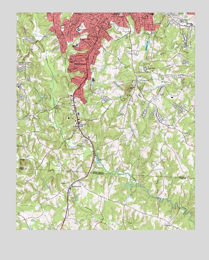
Gastonia South, NC USGS Topographic Map
Click on map above to begin viewing in our Map Viewer.

This topographic map contains these locations and features:
Feature Name Type Latitude Longitude GNIS ID View Map
Anthony CreekStreamN35.2376°W81.1562°980200View Map
Ashbrook High SchoolSchoolN35.2440°W81.1273°980316View Map
Bess Elementary SchoolSchoolN35.1874°W81.1362°1001606View Map
Blackwood CreekStreamN35.2132°W81.2240°981569View Map
Blackwood ParkPopulated PlaceN35.2460°W81.2184°1001608View Map
BoogertownPopulated PlaceN35.2182°W81.1598°1019253View Map
Bowling GreenPopulated PlaceN35.1499°W81.2123°1246952View Map
Bowling Green ChurchChurchN35.1507°W81.2015°1252125View Map
Bowling Green School (historical)SchoolN35.1479°W81.2184°1233611View Map
Bowling Green School (historical)SchoolN35.1507°W81.2020°1233612View Map
Boyd BridgeBridgeN35.1962°W81.2226°981785View Map
Calvary ChurchChurchN35.1437°W81.2090°1221227View Map
Chapel Grove ChurchChurchN35.2201°W81.2451°983010View Map
Chapel Grove SchoolSchoolN35.2079°W81.2479°983012View Map
City of GastoniaCivilN35.2494°W81.1855°2403684View Map
CrowdersPopulated PlaceN35.1862°W81.2065°983803View Map
Crowders (historical)Populated PlaceN35.2365°W81.1634°1001620View Map
Crowders Creek ChurchChurchN35.1729°W81.2442°983805View Map
Davis ParkParkN35.2110°W81.2115°1001624View Map
Delta Shopping CenterLocaleN35.2499°W81.1920°1001625View Map
Dobbs Lake Dam Number OneDamN35.2151°W81.1815°998593View Map
Dobbs Lake Number OneReservoirN35.2151°W81.1815°998594View Map
Edson Shopping CenterLocaleN35.2354°W81.2040°1001632View Map
FallcrestPopulated PlaceN35.2179°W81.2462°1001633View Map
Ferguson BranchStreamN35.1990°W81.2237°985052View Map
Firestone CemeteryCemeteryN35.2435°W81.2122°985080View Map
Firestone Memorial CemeteryCemeteryN35.2493°W81.1767°985082View Map
Forest BrookPopulated PlaceN35.2037°W81.1570°1001635View Map
Forest Brook Shopping CenterLocaleN35.2074°W81.1654°1007900View Map
Forest Heights Elementary SchoolSchoolN35.2471°W81.2281°1001636View Map
Gaston Country Club LakeReservoirN35.2085°W81.1465°998569View Map
Gaston Country Club Lake DamDamN35.2085°W81.1465°998568View Map
Gaston Day SchoolSchoolN35.2012°W81.1581°1001641View Map
Gaston Memorial CemeteryCemeteryN35.2496°W81.1390°985602View Map
Gastonia City Fire Department Station 3BuildingN35.2436°W81.1725°2639563View Map
Gastonia City Fire Department Station 4BuildingN35.2406°W81.1346°2639555View Map
Gastonia City Fire Department Station 5BuildingN35.2353°W81.2025°2639429View Map
Gastonia City Fire Department Station 7BuildingN35.2214°W81.1351°2639255View Map
Gastonia Country ClubLocaleN35.2107°W81.1481°985607View Map
Gastonia Municipal AirportAirportN35.2009°W81.1532°997893View Map
Gastonia Municipal Golf CourseLocaleN35.2365°W81.1795°1001647View Map
Gastonia National Golf CourseLocaleN35.2360°W81.2351°1001648View Map
Gullers LakeReservoirN35.2018°W81.2298°998535View Map
Gullers Lake DamDamN35.2020°W81.2303°998536View Map
H H Beam Elementary SchoolSchoolN35.2229°W81.2009°1001682View Map
Heather LakeReservoirN35.2218°W81.1615°998613View Map
Heather Lake DamDamN35.2218°W81.1615°998612View Map
Huss High SchoolSchoolN35.2401°W81.2065°987293View Map
Jackson KnobSummitN35.2062°W81.1712°1020922View Map
Lake WoodPopulated PlaceN35.2171°W81.1645°1001654View Map
Lingerfeldt Elementary SchoolSchoolN35.2207°W81.2340°1001658View Map
Linwood ParkParkN35.2410°W81.2173°988518View Map
McGill BranchStreamN35.1849°W81.2215°989579View Map
Mount Pisgah ChurchChurchN35.2024°W81.1723°990506View Map
Mount Pleasant ChurchChurchN35.1851°W81.2054°990528View Map
Mount Pleasant Church CemeteryCemeteryN35.1855°W81.2055°2779116View Map
New Hope Post OfficePost OfficeN35.2440°W81.1339°2766588View Map
Olney ChurchChurchN35.2176°W81.1956°991656View Map
Olney Church CemeteryCemeteryN35.2164°W81.1960°2779117View Map
Pisgah ChurchChurchN35.2357°W81.2431°992412View Map
Pleasant Grove ChurchChurchN35.1279°W81.1415°1225539View Map
Pleasant Ridge SchoolSchoolN35.2493°W81.2048°992567View Map
Robinson SchoolSchoolN35.2137°W81.1637°993473View Map
Robinwood ChurchChurchN35.2160°W81.1595°993475View Map
Robinwood Crossing Shopping CenterLocaleN35.2162°W81.1684°1001680View Map
Robinwood LakeReservoirN35.2351°W81.1576°993476View Map
Robinwood Lake DamDamN35.2351°W81.1576°998639View Map
Rocky BranchStreamN35.1440°W81.1506°993559View Map
Sandy Plains ChurchChurchN35.1860°W81.1437°994296View Map
Sandy Plains Church CemeteryCemeteryN35.1861°W81.1444°2779115View Map
Sherwood SchoolSchoolN35.2493°W81.1545°994673View Map
Shoal BranchStreamN35.2346°W81.1454°994744View Map
South Crowders CreekStreamN35.1665°W81.2470°995138View Map
South Fork Crowders CreekStreamN35.1699°W81.1973°995150View Map
South GastoniaPopulated PlaceN35.2193°W81.2056°1022708View Map
Southwest Junior High SchoolSchoolN35.2315°W81.2073°995257View Map
Sunny Acres Farm DamDamN35.1951°W81.1748°998526View Map
Sunny Acres Farm LakeReservoirN35.1951°W81.1748°998527View Map
Township of GastoniaCivilN35.2343°W81.1813°1026699View Map
Union ChurchChurchN35.1801°W81.1320°996452View Map
Union Church CemeteryCemeteryN35.1799°W81.1316°2779114View Map
Union Road ChurchChurchN35.2296°W81.1698°996510View Map
Union Road Volunteer Fire DepartmentBuildingN35.1964°W81.1525°2638295View Map
Weeping Mary ChurchChurchN35.1518°W81.2126°1227463View Map
Wesley ParkPopulated PlaceN35.2471°W81.2012°1001693View Map
WGAS-AM (South Gastonia)TowerN35.2149°W81.1751°1018413View Map
YorkwoodPopulated PlaceN35.2110°W81.2065°1001697View Map
Zion Hill School (historical)SchoolN35.1329°W81.1517°1233993View Map

Note: Coordinates in the location and feature list above are referenced to NAD83 datum.


Copyright (C) 2008-2025 Ryan Niemi / Sunset Dynamics ... All Rights Reserved