TopoQuest Logo
Do you find TopoQuest useful?
Help keep TopoQuest running and adding new maps/features by donating!
Bitcoin:  19c7KJd3qBynnjoSw5npx9KScwjBe4ifkT
Litecoin:  LXs6TkuXGGXo1vDsWCkWVdjQX94eUKd6ui
Home View Maps Find Maps Find Places Resources & Links


Bessemer City, North Carolina Topographic Map

USGS Map Title: Bessemer City, NC
USGS Map MRC: 35081C3
DRG (GeoTIFF) Download: o35081c3.tif


Neighboring USGS Topographic Map Quads:


  Cherryville, NC  
35081D4
 

  Lincolnton West, NC  
35081D3
 

  Lincolnton East, NC  
35081D2
 

  Waco, NC  
35081C4
 

  Bessemer City, NC  
35081C3
 

  Gastonia North, NC  
35081C2
 

  Grover, NC  
35081B4
 

  Kings Mountain, NC  
35081B3
 

  Gastonia South, NC  
35081B2


Map MRC Location:

N36°
W82°
N36°
W81°
H8 H7 H6 H5 H4 H3 H2 H1
G8 G7 G6 G5 G4 G3 G2 G1
F8 F7 F6 F5 F4 F3 F2 F1
E8 E7 E6 E5 E4 E3 E2 E1
D8 D7 D6 D5 D4 D3 D2 D1
C8 C7 C6 C5 C4 C3 C2 C1
B8 B7 B6 B5 B4 B3 B2 B1
A8 A7 A6 A5 A4 A3 A2 A1
N35°
W82°
N35°
W81°

Bessemer City, NC USGS 1:24K Topographic Map Preview:
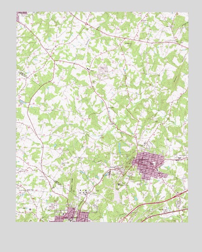
Bessemer City, NC USGS Topographic Map
Click on map above to begin viewing in our Map Viewer.

This topographic map contains these locations and features:
Feature Name Type Latitude Longitude GNIS ID View Map
Abernethy CreekStreamN35.2529°W81.2695°980020View Map
Bessember City Central Elementary SchoolSchoolN35.2851°W81.2767°1024813View Map
Bessemer CityPopulated PlaceN35.2849°W81.2840°981053View Map
Bessemer City High SchoolSchoolN35.2974°W81.2815°981054View Map
Bessemer City Police DepartmentBuildingN35.2853°W81.2852°2769782View Map
Bessemer City Post OfficePost OfficeN35.2823°W81.2829°1986116View Map
Bessemer City Primary SchoolSchoolN35.2996°W81.2767°1001607View Map
Bessemer City QuarryMineN35.3394°W81.3108°2648429View Map
Bessemer City ReservoirReservoirN35.2942°W81.2997°998767View Map
Bessemer City Volunteer Fire DepartmentBuildingN35.2858°W81.2856°2638501View Map
Bethel Associate Reformed Presbyterian Church (historical)ChurchN35.3079°W81.3695°1986136View Map
Bethel ChurchChurchN35.3668°W81.2623°981131View Map
Bingham Memorial ChurchChurchN35.2793°W81.2715°981494View Map
Chestnut RidgeRidgeN35.2729°W81.3340°983123View Map
Chestnut Ridge ChurchChurchN35.2849°W81.3409°983129View Map
City of Bessemer CityCivilN35.2841°W81.2842°2403865View Map
Concord ChurchChurchN35.3329°W81.3192°983431View Map
Crowders Mountain Volunteer Fire and Rescue Station 2BuildingN35.2843°W81.2799°2639825View Map
Ebenezer ChurchChurchN35.2779°W81.3543°984589View Map
Faith ChurchChurchN35.2579°W81.3320°984946View Map
Faith ChurchChurchN35.2815°W81.2845°984948View Map
Gamble HillSummitN35.2520°W81.2794°1020393View Map
Gamble Hill ChurchChurchN35.2574°W81.2667°985533View Map
Grace United Methodist ChurchChurchN35.2529°W81.3295°1986139View Map
Hephzibah ChurchChurchN35.3699°W81.2834°986633View Map
Holland Memorial ChurchChurchN35.2901°W81.2515°986927View Map
Lagoon AReservoirN35.3368°W81.3048°998827View Map
Lagoon A DamDamN35.3368°W81.3048°998828View Map
Lagoon DReservoirN35.3458°W81.3087°998852View Map
Lagoon D DamDamN35.3451°W81.3081°998853View Map
Lincoln Junior High SchoolSchoolN35.2726°W81.2998°988496View Map
Long Creek ChurchChurchN35.2885°W81.3287°988962View Map
Long Creek DamDamN35.2968°W81.2998°998766View Map
Martin Marietta Holding LakeReservoirN35.3430°W81.3139°998850View Map
Martin Marietta Holding Lake DamDamN35.3435°W81.3131°998851View Map
Mount Pisgah ChurchChurchN35.3562°W81.2917°990515View Map
North Elementary SchoolSchoolN35.2551°W81.3404°1024844View Map
Patterson Grove ChurchChurchN35.2685°W81.3676°991939View Map
Penley ChapelChurchN35.2704°W81.3487°992030View Map
PerryPopulated PlaceN35.3335°W81.3484°1001678View Map
Piedmont ChurchChurchN35.2593°W81.3356°992161View Map
Rhynes Airport (historical)AirportN35.3010°W81.2656°997905View Map
Sandy PlainsPopulated PlaceN35.2687°W81.3673°1022494View Map
Sellers LakeReservoirN35.3216°W81.3709°994494View Map
Sellers Lake DamDamN35.3221°W81.3720°998801View Map
Shady Grove ChurchChurchN35.2560°W81.2870°994544View Map
Shady Grove ChurchChurchN35.3529°W81.3531°994546View Map
Storage Area Number TwoReservoirN35.2585°W81.2881°998679View Map
Storage Area Number Two DamDamN35.2585°W81.2881°998680View Map
SunnysidePopulated PlaceN35.3179°W81.3087°1022843View Map
Sunnyside ChurchChurchN35.3090°W81.3042°995700View Map
Township of CherryvilleCivilN35.3720°W81.3281°1026696View Map
Trinity ChurchChurchN35.2754°W81.3545°996239View Map
TryonPopulated PlaceN35.3399°W81.3220°1022992View Map
Tryon County Courthouse Historical SiteParkN35.3315°W81.3031°1001687View Map
Tryon Elementary SchoolSchoolN35.3496°W81.3234°1001688View Map
Tryonota Volunteer Fire DepartmentBuildingN35.3391°W81.3226°2638372View Map
VantinePopulated PlaceN35.2815°W81.3006°996591View Map
Washington ParkParkN35.2846°W81.2737°1001689View Map
West SchoolSchoolN35.2882°W81.2881°997046View Map
Westview GardensCemeteryN35.2718°W81.2626°997085View Map
WKMT-AM (Kings Mountain)TowerN35.2665°W81.3229°1018422View Map

Note: Coordinates in the location and feature list above are referenced to NAD83 datum.


Copyright (C) 2008-2025 Ryan Niemi / Sunset Dynamics ... All Rights Reserved