TopoQuest Logo
Do you find TopoQuest useful?
Help keep TopoQuest running and adding new maps/features by donating!
Bitcoin:  19c7KJd3qBynnjoSw5npx9KScwjBe4ifkT
Litecoin:  LXs6TkuXGGXo1vDsWCkWVdjQX94eUKd6ui
Home View Maps Find Maps Find Places Resources & Links


Gaylesville, Alabama Topographic Map

USGS Map Title: Gaylesville, AL
USGS Map MRC: 34085C5
DRG (GeoTIFF) Download: o34085c5.tif


Neighboring USGS Topographic Map Quads:


  Fort Payne, AL  
34085D6
 

  Jamestown, AL  
34085D5
 

  Lyerly, GA  
34085D4
 

  Little River, AL  
34085C6
 

  Gaylesville, AL  
34085C5
 

  Chattoogaville, GA  
34085C4
 

  Centre, AL  
34085B6
 

  Cedar Bluff, AL  
34085B5
 

  Melson, GA  
34085B4


Map MRC Location:

N35°
W86°
N35°
W85°
H8 H7 H6 H5 H4 H3 H2 H1
G8 G7 G6 G5 G4 G3 G2 G1
F8 F7 F6 F5 F4 F3 F2 F1
E8 E7 E6 E5 E4 E3 E2 E1
D8 D7 D6 D5 D4 D3 D2 D1
C8 C7 C6 C5 C4 C3 C2 C1
B8 B7 B6 B5 B4 B3 B2 B1
A8 A7 A6 A5 A4 A3 A2 A1
N34°
W86°
N34°
W85°

Gaylesville, AL USGS 1:24K Topographic Map Preview:
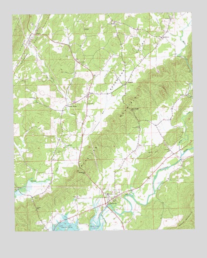
Gaylesville, AL USGS Topographic Map
Click on map above to begin viewing in our Map Viewer.

This topographic map contains these locations and features:
Feature Name Type Latitude Longitude GNIS ID View Map
BlanchePopulated PlaceN34.3634°W85.6100°114481View Map
Blanche Methodist ChurchChurchN34.3659°W85.6086°155797View Map
BroomtownPopulated PlaceN34.3606°W85.5216°114973View Map
Broomtown - Rinehart Volunteer Fire DepartmentBuildingN34.3699°W85.5526°2683077View Map
Broomtown Census Designated PlaceCensusN34.3657°W85.5321°2582666View Map
Broomtown ValleyValleyN34.2928°W85.5862°114974View Map
Cannon CemeteryCemeteryN34.2956°W85.5952°115583View Map
Cedar Bluff-Gaylesville DivisionCivilN34.3221°W85.5585°165686View Map
Chattooga RiverStreamN34.2565°W85.5661°155972View Map
Culstigh CreekStreamN34.3606°W85.5077°116952View Map
Davis CemeteryCemeteryN34.3523°W85.6155°136877View Map
DeweyPopulated PlaceN34.3262°W85.5077°117265View Map
Dirtseller MountainRidgeN34.3065°W85.5605°117297View Map
Dixon Memorial ChurchChurchN34.2912°W85.5983°117318View Map
Dixons Chapel CemeteryCemeteryN34.2915°W85.5983°136880View Map
Erwin SpringSpringN34.2981°W85.5883°149263View Map
Faith ChurchChurchN34.3279°W85.5733°136888View Map
Flint HillSummitN34.2945°W85.5255°118429View Map
Flint Hill ChurchChurchN34.2945°W85.5316°118432View Map
Forest Hill CemeteryCemeteryN34.3095°W85.5383°136893View Map
Forest Hill ChurchChurchN34.3090°W85.5383°118491View Map
Freedom ChurchChurchN34.2970°W85.5958°1699996View Map
GaylesvillePopulated PlaceN34.2684°W85.5569°118879View Map
Gaylesville Baptist ChurchChurchN34.2651°W85.5605°155800View Map
Gaylesville GapGapN34.2834°W85.5755°118880View Map
Gaylesville High SchoolSchoolN34.2709°W85.5602°136898View Map
Gaylesville Post OfficePost OfficeN34.2663°W85.5596°166614View Map
Gaylesville Volunteer Fire DepartmentBuildingN34.2654°W85.5611°2682962View Map
GrasslandPopulated PlaceN34.2984°W85.5883°156429View Map
HurleyPopulated PlaceN34.2751°W85.6230°156509View Map
Jamestown Tabernacle ChurchChurchN34.3662°W85.5764°120817View Map
McCullough GapGapN34.3193°W85.5436°122511View Map
Mills CreekStreamN34.2931°W85.5083°152337View Map
Mount Bethel CemeteryCemeteryN34.3723°W85.5147°136936View Map
Mount Bethel Missionary Baptist ChurchChurchN34.3718°W85.5147°152398View Map
Mount Zion CemeteryCemeteryN34.3679°W85.5525°136940View Map
Mount Zion Wesleyan Methodist ChurchChurchN34.3679°W85.5544°152535View Map
Mountain AcresPopulated PlaceN34.2626°W85.5902°136942View Map
Mud CreekStreamN34.3009°W85.5789°123542View Map
New Prospect ChurchChurchN34.3268°W85.6097°123891View Map
Oak Bowery CemeteryCemeteryN34.2951°W85.5169°136955View Map
Oak Bowery Methodist ChurchChurchN34.2954°W85.5166°152721View Map
Pucket GapGapN34.2634°W85.6102°125350View Map
Randall CemeteryCemeteryN34.2695°W85.5816°153112View Map
RhinehartPopulated PlaceN34.3704°W85.5536°1700001View Map
Rinehart Junior High SchoolSchoolN34.3698°W85.5552°125645View Map
RinggoldPopulated PlaceN34.3340°W85.5477°125647View Map
Stories CemeteryCemeteryN34.2751°W85.6011°136986View Map
Town of GaylesvilleCivilN34.2681°W85.5585°2406555View Map
Union Hill CemeteryCemeteryN34.3479°W85.5786°136999View Map
Union Hill Methodist ChurchChurchN34.3473°W85.5797°153796View Map
Unity Missionary Baptist ChurchChurchN34.2754°W85.6244°137000View Map
Waterloo SpringSpringN34.3212°W85.5883°149269View Map
Waterloo SpringsPopulated PlaceN34.3223°W85.5883°157220View Map
WatsonPopulated PlaceN34.3281°W85.5739°128636View Map
Watson ChapelChurchN34.3240°W85.5739°128638View Map

Note: Coordinates in the location and feature list above are referenced to NAD83 datum.


Copyright (C) 2008-2024 Ryan Niemi / Sunset Dynamics ... All Rights Reserved