TopoQuest Logo
Do you find TopoQuest useful?
Help keep TopoQuest running and adding new maps/features by donating!
Bitcoin:  19c7KJd3qBynnjoSw5npx9KScwjBe4ifkT
Litecoin:  LXs6TkuXGGXo1vDsWCkWVdjQX94eUKd6ui
Home View Maps Find Maps Find Places Resources & Links


Fort Payne, Alabama Topographic Map

USGS Map Title: Fort Payne, AL
USGS Map MRC: 34085D6
DRG (GeoTIFF) Download: o34085d6.tif


Neighboring USGS Topographic Map Quads:


  Sylvania, AL  
34085E7
 

  Dugout Valley, AL  
34085E6
 

  Valley Head, AL  
34085E5
 

  Chavies, AL  
34085D7
 

  Fort Payne, AL  
34085D6
 

  Jamestown, AL  
34085D5
 

  Portersville, AL  
34085C7
 

  Little River, AL  
34085C6
 

  Gaylesville, AL  
34085C5


Map MRC Location:

N35°
W86°
N35°
W85°
H8 H7 H6 H5 H4 H3 H2 H1
G8 G7 G6 G5 G4 G3 G2 G1
F8 F7 F6 F5 F4 F3 F2 F1
E8 E7 E6 E5 E4 E3 E2 E1
D8 D7 D6 D5 D4 D3 D2 D1
C8 C7 C6 C5 C4 C3 C2 C1
B8 B7 B6 B5 B4 B3 B2 B1
A8 A7 A6 A5 A4 A3 A2 A1
N34°
W86°
N34°
W85°

Fort Payne, AL USGS 1:24K Topographic Map Preview:
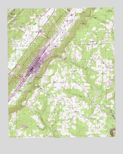
Fort Payne, AL USGS Topographic Map
Click on map above to begin viewing in our Map Viewer.

This topographic map contains these locations and features:
Feature Name Type Latitude Longitude GNIS ID View Map
AdamsburgPopulated PlaceN34.3990°W85.6722°150061View Map
Adamsburg ChurchChurchN34.4023°W85.6733°158265View Map
Adamsburg Junior High SchoolSchoolN34.3998°W85.6733°150645View Map
Adamsburg Volunteer Fire DepartmentBuildingN34.3982°W85.6720°2682693View Map
Baptist Medical Center De KalbHospitalN34.4545°W85.7139°150649View Map
Beeson BranchStreamN34.4656°W85.7344°150084View Map
Beeson GapGapN34.4512°W85.6855°150085View Map
Bell School (historical)SchoolN34.3943°W85.6541°150653View Map
Blake Fire Protection AuthorityBuildingN34.4989°W85.7491°2683474View Map
Brooks BranchStreamN34.3806°W85.6294°150125View Map
Castle RockSummitN34.4365°W85.7041°155574View Map
CED Mental Health CenterBuildingN34.4550°W85.7140°150655View Map
City of Fort PayneCivilN34.4558°W85.6965°2403645View Map
City ParkParkN34.4431°W85.7194°150663View Map
Crystal Lake ChurchChurchN34.4687°W85.6894°150181View Map
DeKalb County CourthouseBuildingN34.4404°W85.7236°150675View Map
DeKalb County Health ClinicHospitalN34.4381°W85.7266°150676View Map
DeKalb County LibraryBuildingN34.4420°W85.7122°150678View Map
Delma ChurchChurchN34.4231°W85.7105°150195View Map
DouglasPopulated PlaceN34.4270°W85.7286°150200View Map
Edna Hill ChurchChurchN34.4006°W85.6275°150216View Map
Ellers ChapelChurchN34.4162°W85.6577°150682View Map
Falls BranchStreamN34.3829°W85.6989°150225View Map
Fisher CemeteryCemeteryN34.4645°W85.6438°150226View Map
Fisher CrossroadsPopulated PlaceN34.4670°W85.6486°156348View Map
Fisher SchoolSchoolN34.4645°W85.6464°150227View Map
Flying J Ranch AirportAirportN34.3911°W85.6619°150605View Map
Forest Avenue Elementary SchoolSchoolN34.4426°W85.7252°150688View Map
Fort PaynePopulated PlaceN34.4443°W85.7197°150235View Map
Fort Payne Academy (historical)SchoolN34.4443°W85.7136°150689View Map
Fort Payne Boom Town Historic DistrictParkN34.4443°W85.7194°158279View Map
Fort Payne City AuditoriumBuildingN34.4426°W85.7122°150690View Map
Fort Payne DivisionCivilN34.4139°W85.7189°165751View Map
Fort Payne Fire and Rescue Station 1BuildingN34.4403°W85.7228°2682708View Map
Fort Payne Fire and Rescue Station 2BuildingN34.4524°W85.7094°2683154View Map
Fort Payne Fire and Rescue Station 3BuildingN34.4510°W85.6852°2683166View Map
Fort Payne Fire and Rescue Station 4BuildingN34.4844°W85.6865°2682875View Map
Fort Payne Fire and Rescue Station 5BuildingN34.4644°W85.6464°2683235View Map
Fort Payne GapGapN34.4243°W85.7133°150236View Map
Fort Payne High SchoolSchoolN34.4876°W85.6741°150691View Map
Fort Payne Main Street Historic DistrictParkN34.4418°W85.7216°158280View Map
Fort Payne Post OfficePost OfficeN34.4405°W85.7208°168414View Map
Fort Payne Recreation CenterBuildingN34.4426°W85.7127°150692View Map
Fort Payne Residential Historic DistrictParkN34.4443°W85.7222°158281View Map
Franklin CemeteryCemeteryN34.4898°W85.7130°150239View Map
Gibson GapGapN34.4954°W85.7472°150251View Map
Glenwood CemeteryCemeteryN34.4348°W85.7319°150259View Map
Green CemeteryCemeteryN34.4592°W85.7325°150263View Map
Hammack CemeteryCemeteryN34.4204°W85.7369°150274View Map
Hicks CreekStreamN34.3854°W85.7041°150287View Map
Husky CemeteryCemeteryN34.4112°W85.7239°150300View Map
Interchange 218CrossingN34.4373°W85.7491°155699View Map
Interchange 222CrossingN34.4779°W85.7125°155700View Map
Isbell FieldAirportN34.4730°W85.7200°150606View Map
Lankford CemeteryCemeteryN34.4695°W85.7294°150326View Map
Last Days ChurchChurchN34.3804°W85.7400°158286View Map
Liberty Hill ChurchChurchN34.4026°W85.6741°150336View Map
Little River FallsFallsN34.3951°W85.6269°150711View Map
Log Cabin ChapelChurchN34.4281°W85.6975°150352View Map
Manitou ParkParkN34.4406°W85.7136°150716View Map
Manitou SpringSpringN34.4284°W85.7236°164223View Map
MinvalePopulated PlaceN34.4593°W85.7116°150382View Map
Moore CemeteryCemeteryN34.4173°W85.6552°150388View Map
Moore School (historical)SchoolN34.4134°W85.6333°150724View Map
Mount Carmel ChurchChurchN34.3931°W85.6566°150392View Map
Mount Zion ChurchChurchN34.4362°W85.6355°150727View Map
New Oregon ChurchChurchN34.4648°W85.6533°152665View Map
Pleasant View ChurchChurchN34.4387°W85.6747°150461View Map
Pumpkin CenterPopulated PlaceN34.4354°W85.6352°150473View Map
Railroad ValleyValleyN34.4668°W85.6966°150474View Map
Rawlingsville (historical)Populated PlaceN34.4612°W85.6986°155417View Map
Rotch and Cassidy DamDamN34.4234°W85.6316°150621View Map
Rotch and Cassidy LakeReservoirN34.4234°W85.6316°150620View Map
Scott CemeteryCemeteryN34.4654°W85.6927°150503View Map
Steward GapGapN34.4909°W85.6486°150530View Map
Steward SpringSpringN34.4959°W85.6622°150531View Map
Stewart CemeteryCemeteryN34.4276°W85.6847°150532View Map
Straight CreekStreamN34.4062°W85.6427°150535View Map
Sulphur Springs CemeteryCemeteryN34.4965°W85.6764°150541View Map
Tate HollowValleyN34.4951°W85.7055°150547View Map
Temple DamDamN34.3851°W85.7283°150617View Map
Temples LakeReservoirN34.3861°W85.7315°150616View Map
Union ChurchChurchN34.4918°W85.7450°150563View Map
Union Hill ChurchChurchN34.4465°W85.6366°150565View Map
Walnut Grove Baptist ChurchChurchN34.4929°W85.7108°150575View Map
WFPA-AM (Fort Payne)TowerN34.4393°W85.7025°161072View Map
Williams Avenue Athletic FacilitiesParkN34.4556°W85.7083°150753View Map
Williams Avenue Junior High SchoolSchoolN34.4559°W85.7066°150754View Map
Wills ValleyPopulated PlaceN34.4779°W85.7141°157266View Map
Willstown Mission (historical)ChurchN34.4751°W85.6811°155418View Map
Yellow CreekStreamN34.3965°W85.6275°150603View Map

Note: Coordinates in the location and feature list above are referenced to NAD83 datum.


Copyright (C) 2008-2025 Ryan Niemi / Sunset Dynamics ... All Rights Reserved