TopoQuest Logo
Do you find TopoQuest useful?
Help keep TopoQuest running and adding new maps/features by donating!
Bitcoin:  19c7KJd3qBynnjoSw5npx9KScwjBe4ifkT
Litecoin:  LXs6TkuXGGXo1vDsWCkWVdjQX94eUKd6ui
Home View Maps Find Maps Find Places Resources & Links


Little River, Alabama Topographic Map

USGS Map Title: Little River, AL
USGS Map MRC: 34085C6
DRG (GeoTIFF) Download: o34085c6.tif


Neighboring USGS Topographic Map Quads:


  Chavies, AL  
34085D7
 

  Fort Payne, AL  
34085D6
 

  Jamestown, AL  
34085D5
 

  Portersville, AL  
34085C7
 

  Little River, AL  
34085C6
 

  Gaylesville, AL  
34085C5
 

  Leesburg, AL  
34085B7
 

  Centre, AL  
34085B6
 

  Cedar Bluff, AL  
34085B5


Map MRC Location:

N35°
W86°
N35°
W85°
H8 H7 H6 H5 H4 H3 H2 H1
G8 G7 G6 G5 G4 G3 G2 G1
F8 F7 F6 F5 F4 F3 F2 F1
E8 E7 E6 E5 E4 E3 E2 E1
D8 D7 D6 D5 D4 D3 D2 D1
C8 C7 C6 C5 C4 C3 C2 C1
B8 B7 B6 B5 B4 B3 B2 B1
A8 A7 A6 A5 A4 A3 A2 A1
N34°
W86°
N34°
W85°

Little River, AL USGS 1:24K Topographic Map Preview:
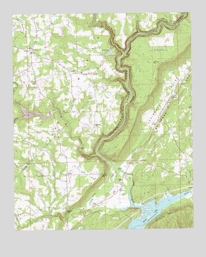
Little River, AL USGS Topographic Map
Click on map above to begin viewing in our Map Viewer.

This topographic map contains these locations and features:
Feature Name Type Latitude Longitude GNIS ID View Map
Barrets ChapelChurchN34.3195°W85.6252°155850View Map
Bear CreekStreamN34.3518°W85.6730°150082View Map
Black Oak Baptist ChurchChurchN34.3106°W85.6936°114432View Map
Black Oak CemeteryCemeteryN34.3104°W85.6927°136843View Map
Camprock CreekStreamN34.3170°W85.7411°150143View Map
Canyon Mouth ParkParkN34.2887°W85.6833°1805689View Map
Canyon ParkLocaleN34.3498°W85.6872°150146View Map
Cash DamDamN34.3151°W85.7250°150615View Map
Cashs LakeReservoirN34.3177°W85.7347°150614View Map
Coffey CemeteryCemeteryN34.2712°W85.6808°116362View Map
Coffey Plantation (historical)LocaleN34.2701°W85.6816°1805690View Map
CongoPopulated PlaceN34.3109°W85.6508°156207View Map
Congo SpringSpringN34.2956°W85.6636°149262View Map
Daniels CemeteryCemeteryN34.2701°W85.6747°117053View Map
Daniels Chapel Methodist ChurchChurchN34.2784°W85.6750°155861View Map
Daniels GapGapN34.2807°W85.6886°117055View Map
Daniels Mill (historical)LocaleN34.2912°W85.6861°136875View Map
DogtownPopulated PlaceN34.3529°W85.7369°157935View Map
Dogtown Volunteer Fire DepartmentBuildingN34.3547°W85.7366°2683446View Map
Flying M Ranch AirportAirportN34.3231°W85.6428°2676373View Map
Free Pentecost ChurchChurchN34.3409°W85.6255°1699995View Map
Johnnies CreekStreamN34.2937°W85.6925°151896View Map
LickskilletPopulated PlaceN34.3404°W85.6958°150709View Map
Little RiverPopulated PlaceN34.2815°W85.6733°121858View Map
Little River Baptist ChurchChurchN34.2726°W85.6764°155879View Map
Little River CanyonValleyN34.2890°W85.6832°163935View Map
Lookout Mountain ChurchChurchN34.3715°W85.7352°158288View Map
LoopPopulated PlaceN34.3229°W85.6427°122027View Map
Mount Moriah ChurchChurchN34.3398°W85.6989°152448View Map
Mount Zion (historical)Populated PlaceN34.2793°W85.7402°164494View Map
Mount Zion ChurchChurchN34.2587°W85.7477°123491View Map
Needle RockPillarN34.3743°W85.6314°150415View Map
Needle RockArchN34.3742°W85.6314°2571544View Map
Pleasant Hill CemeteryCemeteryN34.3259°W85.6397°136960View Map
Pleasant Hill ChurchChurchN34.3268°W85.6394°125012View Map
PowellPopulated PlaceN34.2865°W85.7494°150466View Map
Ruhama Baptist ChurchChurchN34.3537°W85.7397°150497View Map
Ruhama Junior High SchoolSchoolN34.3543°W85.7380°150498View Map
Shinbone ValleyValleyN34.2888°W85.6723°126764View Map
SigsbeePopulated PlaceN34.3415°W85.7100°157058View Map
Spring CreekStreamN34.2606°W85.6483°153526View Map
Starling CemeteryCemeteryN34.2645°W85.6927°127319View Map
Starling GapGapN34.2606°W85.7155°127320View Map
TaftPopulated PlaceN34.3423°W85.6272°157140View Map
Taft SpringSpringN34.3284°W85.6341°149268View Map
Thomson GapGapN34.3459°W85.6489°127916View Map
Tucker (historical)Populated PlaceN34.3084°W85.7186°164496View Map
Tuckers Chapel CemeteryCemeteryN34.2820°W85.7122°136993View Map
Tuckers Chapel Methodist ChurchChurchN34.2823°W85.7125°155925View Map
Tuckers Chapel Volunteer Fire DepartmentBuildingN34.2811°W85.7135°2682766View Map
Unity CemeteryCemeteryN34.2768°W85.6258°128357View Map
Walkers Chapel Methodist ChurchChurchN34.3348°W85.7341°155929View Map
Welcome Hill Baptist ChurchChurchN34.2818°W85.7300°153920View Map
Welcome Hill CemeteryCemeteryN34.2815°W85.7308°137005View Map
Wolf CreekStreamN34.2626°W85.6652°150600View Map

Note: Coordinates in the location and feature list above are referenced to NAD83 datum.


Copyright (C) 2008-2024 Ryan Niemi / Sunset Dynamics ... All Rights Reserved