TopoQuest Logo
Do you find TopoQuest useful?
Help keep TopoQuest running and adding new maps/features by donating!
Bitcoin:  19c7KJd3qBynnjoSw5npx9KScwjBe4ifkT
Litecoin:  LXs6TkuXGGXo1vDsWCkWVdjQX94eUKd6ui
Home View Maps Find Maps Find Places Resources & Links


Ashville, Alabama Topographic Map

USGS Map Title: Ashville, AL
USGS Map MRC: 33086G3
DRG (GeoTIFF) Download: o33086g3.tif


Neighboring USGS Topographic Map Quads:


  Oneonta, AL  
33086H4
 

  Hyatt Gap, AL  
33086H3
 

  Steele, AL  
33086H2
 

  Springville, AL  
33086G4
 

  Ashville, AL  
33086G3
 

  Cox Gap, AL  
33086G2
 

  Odenville, AL  
33086F4
 

  Wattsville, AL  
33086F3
 

  Ragland, AL  
33086F2


Map MRC Location:

N34°
W87°
N34°
W86°
H8 H7 H6 H5 H4 H3 H2 H1
G8 G7 G6 G5 G4 G3 G2 G1
F8 F7 F6 F5 F4 F3 F2 F1
E8 E7 E6 E5 E4 E3 E2 E1
D8 D7 D6 D5 D4 D3 D2 D1
C8 C7 C6 C5 C4 C3 C2 C1
B8 B7 B6 B5 B4 B3 B2 B1
A8 A7 A6 A5 A4 A3 A2 A1
N33°
W87°
N33°
W86°

Ashville, AL USGS 1:24K Topographic Map Preview:
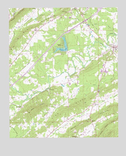
Ashville, AL USGS Topographic Map
Click on map above to begin viewing in our Map Viewer.

This topographic map contains these locations and features:
Feature Name Type Latitude Longitude GNIS ID View Map
Alverson ChurchChurchN33.8743°W86.3444°164536View Map
Appalachian HighlandsAreaN33.8334°W86.3333°165299View Map
AshvillePopulated PlaceN33.8370°W86.2544°164539View Map
Ashville Academy (historical)SchoolN33.8348°W86.2516°165007View Map
Ashville Fire and RescueBuildingN33.8538°W86.2669°2683361View Map
Ashville High SchoolSchoolN33.8209°W86.2664°165008View Map
Ashville Police DepartmentBuildingN33.8359°W86.2520°2751861View Map
Ashville Post OfficePost OfficeN33.8425°W86.2653°2789050View Map
Barker MountainSummitN33.7762°W86.3497°164551View Map
Beaver Creek MountainsRidgeN33.7707°W86.2766°164555View Map
Big RidgeRidgeN33.8554°W86.3505°164562View Map
Bucks ValleyValleyN33.8045°W86.3111°164582View Map
CaldwellPopulated PlaceN33.8123°W86.3644°164586View Map
Cedar CliffCliffN33.7742°W86.3502°164598View Map
City of AshvilleCivilN33.8331°W86.2698°2403122View Map
Coal Springs ChurchChurchN33.7920°W86.3289°165039View Map
Cobb DamDamN33.8018°W86.3150°164979View Map
Cobb LakeReservoirN33.8005°W86.3139°164978View Map
Cool SpringsPopulated PlaceN33.7968°W86.3291°164615View Map
Cool Springs Volunteer Fire DepartmentBuildingN33.7724°W86.3292°2683341View Map
Dry CreekStreamN33.8090°W86.3055°164633View Map
Early Church (historical)ChurchN33.8682°W86.3239°165054View Map
Evergreen ChurchChurchN33.8601°W86.2861°164649View Map
Fairview Church Number 2ChurchN33.7798°W86.3616°164652View Map
Farr DamDamN33.8118°W86.2666°164982View Map
Farr S LakeReservoirN33.8118°W86.2666°164983View Map
Fellowship ChurchChurchN33.7623°W86.2803°165064View Map
Goat Hill School (historical)SchoolN33.7873°W86.3725°165077View Map
Interchange 166CrossingN33.8626°W86.2869°165333View Map
Left Hand Prong Little Canoe CreekStreamN33.7790°W86.3722°165114View Map
Lighthouse ChurchChurchN33.8326°W86.3072°165321View Map
Little Canoe CreekStreamN33.7884°W86.3539°164734View Map
Littlefatche (historical)LocaleN33.7668°W86.2666°165116View Map
Locust BranchStreamN33.8493°W86.2536°164740View Map
McCrory GapGapN33.7648°W86.2803°164751View Map
Moore CemeteryCemeteryN33.8048°W86.3078°164761View Map
Mount Beulah ChurchChurchN33.7887°W86.3725°164765View Map
Muckleroy CreekStreamN33.8398°W86.2778°164776View Map
Murrays ChapelChurchN33.8534°W86.3425°164777View Map
New Haven ChurchChurchN33.7559°W86.3275°165152View Map
North Fork Dry CreekStreamN33.7990°W86.2972°164786View Map
Peterson FieldAirportN33.8652°W86.3112°2787272View Map
Pine Forest ChurchChurchN33.7823°W86.2755°164803View Map
Pinedale DamDamN33.8351°W86.3066°164984View Map
Pinedale LakeReservoirN33.8349°W86.3156°164806View Map
Pinedale ShoresPopulated PlaceN33.8384°W86.3141°164807View Map
Pinedale Shores ChurchChurchN33.8295°W86.3122°165169View Map
Pinedale Volunteer Fire DepartmentBuildingN33.8323°W86.3085°2683342View Map
Pleasant Hill ChurchChurchN33.7509°W86.2978°164811View Map
Reeves Grove CemeteryCemeteryN33.8709°W86.3078°1805471View Map
Reeves Grove ChurchChurchN33.8707°W86.3086°164829View Map
Saint Clair County Farm (historical)LocaleN33.7987°W86.2733°165185View Map
Saint Clair Sheriff's OfficeBuildingN33.8383°W86.2540°2751944View Map
South Fork Dry CreekStreamN33.7990°W86.2972°164860View Map
Stolle DamDamN33.8118°W86.2633°164981View Map
Stolle LakeReservoirN33.8135°W86.2636°164980View Map
Walker BranchStreamN33.8401°W86.3750°164899View Map
WhitneyPopulated PlaceN33.8679°W86.2914°164909View Map
Whitney JunctionPopulated PlaceN33.8748°W86.2994°164910View Map
WoodallLocaleN33.8473°W86.3178°165225View Map

Note: Coordinates in the location and feature list above are referenced to NAD83 datum.


Copyright (C) 2008-2024 Ryan Niemi / Sunset Dynamics ... All Rights Reserved