TopoQuest Logo
Do you find TopoQuest useful?
Help keep TopoQuest running and adding new maps/features by donating!
Bitcoin:  19c7KJd3qBynnjoSw5npx9KScwjBe4ifkT
Litecoin:  LXs6TkuXGGXo1vDsWCkWVdjQX94eUKd6ui
Home View Maps Find Maps Find Places Resources & Links


Georgetown, Kentucky Topographic Map

USGS Map Title: Georgetown, KY
USGS Map MRC: 38084B5
DRG (GeoTIFF) Download: o38084b5.tif


Neighboring USGS Topographic Map Quads:


  Stamping Ground, KY  
38084C6
 

  Delaplain, KY  
38084C5
 

  Leesburg, KY  
38084C4
 

  Midway, KY  
38084B6
 

  Georgetown, KY  
38084B5
 

  Centerville, KY  
38084B4
 

  Versailles, KY  
38084A6
 

  Lexington West, KY  
38084A5
 

  Lexington East, KY  
38084A4


Map MRC Location:

N39°
W85°
N39°
W84°
H8 H7 H6 H5 H4 H3 H2 H1
G8 G7 G6 G5 G4 G3 G2 G1
F8 F7 F6 F5 F4 F3 F2 F1
E8 E7 E6 E5 E4 E3 E2 E1
D8 D7 D6 D5 D4 D3 D2 D1
C8 C7 C6 C5 C4 C3 C2 C1
B8 B7 B6 B5 B4 B3 B2 B1
A8 A7 A6 A5 A4 A3 A2 A1
N38°
W85°
N38°
W84°

Georgetown, KY USGS 1:24K Topographic Map Preview:
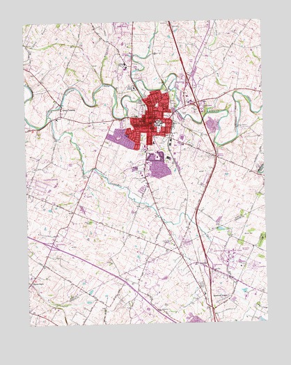
Georgetown, KY USGS Topographic Map
Click on map above to begin viewing in our Map Viewer.

This topographic map contains these locations and features:
Feature Name Type Latitude Longitude GNIS ID View Map
Berea ChurchChurchN38.1415°W84.5161°486900View Map
Bethel ChurchChurchN38.1306°W84.5847°486988View Map
Cane RunStreamN38.2106°W84.6133°488799View Map
Cane Run ChurchChurchN38.1459°W84.5274°488803View Map
Cardome AcademySchoolN38.2229°W84.5666°488931View Map
City of GeorgetownCivilN38.2252°W84.5481°2403689View Map
Clabber BottomPopulated PlaceN38.1937°W84.5244°516988View Map
Crest Lawn GardensCemeteryN38.1594°W84.5497°490327View Map
DonerailPopulated PlaceN38.1492°W84.5349°507866View Map
Dry RunStreamN38.2251°W84.5658°491240View Map
Dry Run BridgeBridgeN38.2451°W84.5555°2558392View Map
Garth SchoolSchoolN38.2056°W84.5586°492734View Map
GeorgetownPopulated PlaceN38.2098°W84.5588°492790View Map
Georgetown - Scott County Emergency Medical ServicesBuildingN38.2090°W84.5603°2719154View Map
Georgetown CollegeSchoolN38.2070°W84.5547°492791View Map
Georgetown Community HospitalHospitalN38.1866°W84.5613°2660361View Map
Georgetown DivisionCivilN38.2175°W84.5770°1937019View Map
Georgetown Fire and Rescue Station 1BuildingN38.2089°W84.5603°2636716View Map
Georgetown Fire and Rescue Station 2BuildingN38.2193°W84.5418°2636561View Map
Georgetown Fire and Rescue Station 3BuildingN38.1885°W84.5644°2636805View Map
Georgetown Police DepartmentBuildingN38.1946°W84.5517°2767650View Map
Great CrossingPopulated PlaceN38.2145°W84.6052°493245View Map
HerdonPopulated PlaceN38.1784°W84.5938°516989View Map
Indian HillsPopulated PlaceN38.2031°W84.5686°494962View Map
Kentucky State Horse ParkParkN38.1504°W84.5211°516990View Map
Lancelot EstatesPopulated PlaceN38.1834°W84.6233°516991View Map
Lanes RunStreamN38.2123°W84.5286°495977View Map
Man O' War Historical MarkerParkN38.1495°W84.5202°2744318View Map
Maple Grove CemeteryCemeteryN38.2170°W84.5397°497505View Map
Marshall Field (historical)AirportN38.1881°W84.5669°517023View Map
McCracken CreekStreamN38.2248°W84.5833°497822View Map
Miller RunStreamN38.2151°W84.5061°498351View Map
Paynes DepotPopulated PlaceN38.1420°W84.6236°500296View Map
PeakPopulated PlaceN38.1754°W84.6097°516992View Map
Royal SpringsSpringN38.2083°W84.5622°502438View Map
Scott County Fire Department Station 6BuildingN38.2154°W84.5584°2637146View Map
Scott County Sheriff's OfficeBuildingN38.2107°W84.5578°2767492View Map
ShiffPopulated PlaceN38.2406°W84.5961°516993View Map
Spindletop EstatesPopulated PlaceN38.1345°W84.5230°509110View Map
Steeplechase RacetrackParkN38.1545°W84.5108°516994View Map
Stone Hedge EstatesPopulated PlaceN38.2487°W84.5702°516995View Map
University of Kentucky Agricultural Experimental StationSchoolN38.1315°W84.5049°505848View Map
WAXU-AM (Georgetown)TowerN38.1681°W84.5936°517814View Map
WRVG-FM (Georgetown)TowerN38.2076°W84.5566°517946View Map

Note: Coordinates in the location and feature list above are referenced to NAD83 datum.


Copyright (C) 2008-2025 Ryan Niemi / Sunset Dynamics ... All Rights Reserved