TopoQuest Logo
Do you find TopoQuest useful?
Help keep TopoQuest running and adding new maps/features by donating!
Bitcoin:  19c7KJd3qBynnjoSw5npx9KScwjBe4ifkT
Litecoin:  LXs6TkuXGGXo1vDsWCkWVdjQX94eUKd6ui
Home View Maps Find Maps Find Places Resources & Links


Delaplain, Kentucky Topographic Map

USGS Map Title: Delaplain, KY
USGS Map MRC: 38084C5
DRG (GeoTIFF) Download: o38084c5.tif


Neighboring USGS Topographic Map Quads:


  New Columbus, KY  
38084D6
 

  Sadieville, KY  
38084D5
 

  Breckinridge, KY  
38084D4
 

  Stamping Ground, KY  
38084C6
 

  Delaplain, KY  
38084C5
 

  Leesburg, KY  
38084C4
 

  Midway, KY  
38084B6
 

  Georgetown, KY  
38084B5
 

  Centerville, KY  
38084B4


Map MRC Location:

N39°
W85°
N39°
W84°
H8 H7 H6 H5 H4 H3 H2 H1
G8 G7 G6 G5 G4 G3 G2 G1
F8 F7 F6 F5 F4 F3 F2 F1
E8 E7 E6 E5 E4 E3 E2 E1
D8 D7 D6 D5 D4 D3 D2 D1
C8 C7 C6 C5 C4 C3 C2 C1
B8 B7 B6 B5 B4 B3 B2 B1
A8 A7 A6 A5 A4 A3 A2 A1
N38°
W85°
N38°
W84°

Delaplain, KY USGS 1:24K Topographic Map Preview:
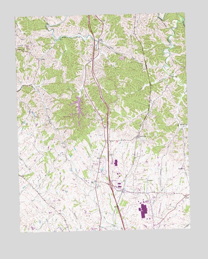
Delaplain, KY USGS Topographic Map
Click on map above to begin viewing in our Map Viewer.

This topographic map contains these locations and features:
Feature Name Type Latitude Longitude GNIS ID View Map
BiddlePopulated PlaceN38.3495°W84.6074°507505View Map
BoydtownPopulated PlaceN38.2842°W84.5027°507567View Map
Burgess CemeteryCemeteryN38.3023°W84.5019°488417View Map
CranetownPopulated PlaceN38.2773°W84.5308°507773View Map
DelaplainPopulated PlaceN38.2737°W84.5486°490791View Map
Double CulvertPopulated PlaceN38.3595°W84.5641°507870View Map
Dry Run ChurchChurchN38.2756°W84.5674°491241View Map
East Fork Eagle CreekStreamN38.3717°W84.5016°491457View Map
Fish BranchStreamN38.3606°W84.5936°492103View Map
Griffith BranchStreamN38.3587°W84.5638°493388View Map
Humphreys LakesReservoirN38.3116°W84.6204°2558393View Map
Mallard PointPopulated PlaceN38.3179°W84.5761°516996View Map
Moon Lake EstatesPopulated PlaceN38.2873°W84.5613°516997View Map
Mount Olive ChurchChurchN38.3017°W84.5574°498795View Map
Muddy FordPopulated PlaceN38.3092°W84.5024°508656View Map
Muddy Ford CreekStreamN38.3079°W84.5066°499039View Map
OxfordPopulated PlaceN38.2684°W84.5030°500088View Map
Rogers GapPopulated PlaceN38.3045°W84.5361°502279View Map
Rogers Gap CreekStreamN38.3390°W84.5127°502280View Map
Sadieville DivisionCivilN38.3582°W84.5170°1937232View Map
Salem ChurchChurchN38.3612°W84.5919°516998View Map
Scott CountyCivilN38.2916°W84.5839°516951View Map
Scott County Fire Department Station 1BuildingN38.2801°W84.5686°2637142View Map
Sharon BranchStreamN38.3087°W84.5008°503252View Map
Shawnee BranchStreamN38.3376°W84.5136°503283View Map
Turkey FootPopulated PlaceN38.3384°W84.5111°509245View Map
West Fork Eagle CreekStreamN38.3390°W84.5127°506432View Map
Wolf BranchStreamN38.3529°W84.5624°506988View Map

Note: Coordinates in the location and feature list above are referenced to NAD83 datum.


Copyright (C) 2008-2025 Ryan Niemi / Sunset Dynamics ... All Rights Reserved