TopoQuest Logo
Do you find TopoQuest useful?
Help keep TopoQuest running and adding new maps/features by donating!
Bitcoin:  19c7KJd3qBynnjoSw5npx9KScwjBe4ifkT
Litecoin:  LXs6TkuXGGXo1vDsWCkWVdjQX94eUKd6ui
Home View Maps Find Maps Find Places Resources & Links


Germantown Hills, Illinois Topographic Map

USGS Map Title: Germantown Hills, IL
USGS Map MRC: 40089G4
DRG (GeoTIFF) Download: o40089g4.tif


Neighboring USGS Topographic Map Quads:


  Rome, IL  
40089H5
 

  Chillicothe, IL  
40089H4
 

  Washburn, IL  
40089H3
 

  Spring Bay, IL  
40089G5
 

  Germantown Hills, IL  
40089G4
 

  Metamora, IL  
40089G3
 

  Peoria East, IL  
40089F5
 

  Washington, IL  
40089F4
 

  Eureka, IL  
40089F3


Map MRC Location:

N41°
W90°
N41°
W89°
H8 H7 H6 H5 H4 H3 H2 H1
G8 G7 G6 G5 G4 G3 G2 G1
F8 F7 F6 F5 F4 F3 F2 F1
E8 E7 E6 E5 E4 E3 E2 E1
D8 D7 D6 D5 D4 D3 D2 D1
C8 C7 C6 C5 C4 C3 C2 C1
B8 B7 B6 B5 B4 B3 B2 B1
A8 A7 A6 A5 A4 A3 A2 A1
N40°
W90°
N40°
W89°

Germantown Hills, IL USGS 1:24K Topographic Map Preview:
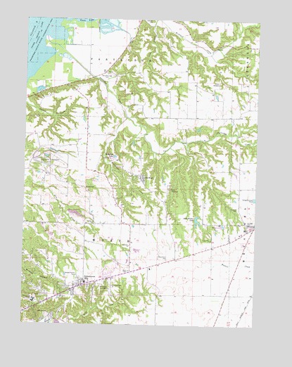
Germantown Hills, IL USGS Topographic Map
Click on map above to begin viewing in our Map Viewer.

This topographic map contains these locations and features:
Feature Name Type Latitude Longitude GNIS ID View Map
Alcott School (historical)SchoolN40.8392°W89.3793°1801979View Map
Black Partridge CemeteryCemeteryN40.8525°W89.4573°404498View Map
Camp TapawingoLocaleN40.8059°W89.4206°405505View Map
Camp WildwoodLocaleN40.8495°W89.3954°405512View Map
Christ ChurchChurchN40.7661°W89.4715°1824259View Map
Christian Union ChurchChurchN40.7895°W89.3754°2041410View Map
Faith Bible ChurchChurchN40.7825°W89.4429°408240View Map
Germantown HillsPopulated PlaceN40.7664°W89.4679°408975View Map
Germantown Hills Baptist ChurchChurchN40.7661°W89.4518°408976View Map
Germantown Hills Community CenterBuildingN40.7642°W89.4715°2041405View Map
Germantown Hills Elementary SchoolSchoolN40.7673°W89.4662°1824278View Map
Germantown Hills Fire Protection DistrictBuildingN40.7671°W89.4722°2041406View Map
Germantown Hills Middle SchoolSchoolN40.7689°W89.4504°2041408View Map
Germantown Hills Town HallBuildingN40.7675°W89.4715°2041407View Map
Haedicke CemeteryCemeteryN40.7548°W89.4876°409603View Map
Hickory PointPopulated PlaceN40.7773°W89.4181°1824280View Map
Hickory Point CemeteryCemeteryN40.7767°W89.4225°410176View Map
Hickory Point School (historical)SchoolN40.7767°W89.4179°1801998View Map
Illinois State Police Department District 8BuildingN40.7721°W89.4430°2041409View Map
Izaak Walton LakeLakeN40.7929°W89.4068°410983View Map
Izaak Walton Lake DamDamN40.7936°W89.4070°1691371View Map
John D Rennick Airport (historical)AirportN40.8638°W89.4472°427824View Map
Lake Santa FeReservoirN40.7956°W89.4725°1692243View Map
Lake Santa Fe DamDamN40.7967°W89.4768°1692242View Map
Lone Hill CemeteryCemeteryN40.8748°W89.4337°412535View Map
Lourdes ChurchChurchN40.7914°W89.4631°412684View Map
Mount Alerno NovitiateChurchN40.7603°W89.4943°413926View Map
Mundinger CreekStreamN40.8350°W89.4456°414235View Map
Oak RidgePopulated PlaceN40.8114°W89.4376°414846View Map
Oakenwald School (historical)SchoolN40.8498°W89.4081°1802012View Map
Oakhill School (historical)SchoolN40.8059°W89.4343°1802013View Map
Oakwood CemeteryCemeteryN40.7971°W89.3845°414930View Map
Partridge CreekStreamN40.8639°W89.4895°415424View Map
Partridge School (historical)SchoolN40.8506°W89.4698°1802017View Map
Pleasant View School (historical)SchoolN40.8236°W89.4770°1802021View Map
Prairie Lake School (historical)SchoolN40.7628°W89.4187°1802022View Map
Saint Marys Roman CemeteryCemeteryN40.7928°W89.3801°417565View Map
Township of WorthCivilN40.7913°W89.4458°429959View Map
Tuckaway Manor Mobile Home ParkPopulated PlaceN40.7653°W89.4775°2628266View Map
Village of Germantown HillsCivilN40.7717°W89.4666°2398956View Map
WBZM-FM (Chillicothe)TowerN40.8300°W89.4984°428172View Map
Wernsmans Airport (historical)AirportN40.7648°W89.4579°427535View Map
Wildwind LakeLakeN40.8188°W89.4515°421161View Map
Willow Hill ChurchChurchN40.7611°W89.4843°2041404View Map
Winkler CemeteryCemeteryN40.8062°W89.4670°421331View Map

Note: Coordinates in the location and feature list above are referenced to NAD83 datum.


Copyright (C) 2008-2024 Ryan Niemi / Sunset Dynamics ... All Rights Reserved