TopoQuest Logo
Do you find TopoQuest useful?
Help keep TopoQuest running and adding new maps/features by donating!
Bitcoin:  19c7KJd3qBynnjoSw5npx9KScwjBe4ifkT
Litecoin:  LXs6TkuXGGXo1vDsWCkWVdjQX94eUKd6ui
Home View Maps Find Maps Find Places Resources & Links


Washburn, Illinois Topographic Map

USGS Map Title: Washburn, IL
USGS Map MRC: 40089H3
DRG (GeoTIFF) Download: o40089h3.tif


Neighboring USGS Topographic Map Quads:


  Lacon, IL  
41089A4
 

  Henry, IL  
41089A3
 

  Varna, IL  
41089A2
 

  Chillicothe, IL  
40089H4
 

  Washburn, IL  
40089H3
 

  La Rose, IL  
40089H2
 

  Germantown Hills, IL  
40089G4
 

  Metamora, IL  
40089G3
 

  Roanoke, IL  
40089G2


Map MRC Location:

N41°
W90°
N41°
W89°
H8 H7 H6 H5 H4 H3 H2 H1
G8 G7 G6 G5 G4 G3 G2 G1
F8 F7 F6 F5 F4 F3 F2 F1
E8 E7 E6 E5 E4 E3 E2 E1
D8 D7 D6 D5 D4 D3 D2 D1
C8 C7 C6 C5 C4 C3 C2 C1
B8 B7 B6 B5 B4 B3 B2 B1
A8 A7 A6 A5 A4 A3 A2 A1
N40°
W90°
N40°
W89°

Washburn, IL USGS 1:24K Topographic Map Preview:
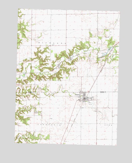
Washburn, IL USGS Topographic Map
Click on map above to begin viewing in our Map Viewer.

This topographic map contains these locations and features:
Feature Name Type Latitude Longitude GNIS ID View Map
Barnes CemeteryCemeteryN40.9513°W89.3060°403911View Map
Bell CemeteryCemeteryN40.9652°W89.2738°404120View Map
Buckingham CemeteryCemeteryN40.9041°W89.3462°405133View Map
Crow Meadow Presbyterian CemeteryCemeteryN40.9754°W89.2674°406849View Map
Fort Dever CemeteryCemeteryN40.9567°W89.3109°408549View Map
Garfield School (historical)SchoolN40.9659°W89.3573°1720202View Map
Garrison School (historical)SchoolN40.9009°W89.3437°1801989View Map
Greeley School (historical)SchoolN40.8811°W89.2562°1801992View Map
Hull School (historical)SchoolN40.9959°W89.3062°1720203View Map
Linn Mount Vernon CemeteryCemeteryN40.9065°W89.2746°414094View Map
Lowpoint-Washburn Elementary SchoolSchoolN40.9245°W89.2956°1808856View Map
Lowpoint-Washburn High SchoolSchoolN40.9195°W89.2809°1824284View Map
Lutheran CemeteryCemeteryN40.9205°W89.2958°1953793View Map
Maple School (historical)SchoolN40.9367°W89.3601°1720206View Map
North Branch Crow CreekStreamN40.9664°W89.2565°414566View Map
Saint Elizabeth Catholic CemeteryCemeteryN40.9197°W89.3082°1953811View Map
Sherwoods RunStreamN40.9656°W89.2820°1808667View Map
South Branch Crow CreekStreamN40.9661°W89.2565°418722View Map
Strawn School (historical)SchoolN40.9956°W89.3584°1720210View Map
Sulphur Spring School (historical)SchoolN40.9400°W89.2565°1720211View Map
Township of CazenoviaCivilN40.8796°W89.3321°428778View Map
Township of RichlandCivilN40.9667°W89.3338°429631View Map
Vernon School (historical)SchoolN40.9103°W89.2562°1802042View Map
Village of WashburnCivilN40.9203°W89.2918°2400097View Map
WashburnPopulated PlaceN40.9192°W89.2912°420548View Map
Washburn Fire Protection DistrictBuildingN40.9181°W89.2895°2640765View Map
Washburn Post OfficePost OfficeN40.9174°W89.2916°2788586View Map
Webster School (historical)SchoolN40.8948°W89.2984°1802045View Map
WilbernPopulated PlaceN40.9467°W89.3237°423308View Map

Note: Coordinates in the location and feature list above are referenced to NAD83 datum.


Copyright (C) 2008-2025 Ryan Niemi / Sunset Dynamics ... All Rights Reserved