TopoQuest Logo
Do you find TopoQuest useful?
Help keep TopoQuest running and adding new maps/features by donating!
Bitcoin:  19c7KJd3qBynnjoSw5npx9KScwjBe4ifkT
Litecoin:  LXs6TkuXGGXo1vDsWCkWVdjQX94eUKd6ui
Home View Maps Find Maps Find Places Resources & Links


Gilleyville, Louisiana Topographic Map

USGS Map Title: Gilleyville, LA
USGS Map MRC: 32091C8
DRG (GeoTIFF) Download: o32091c8.tif


Neighboring USGS Topographic Map Quads:


  Monroe South, LA  
32092D1
 

  Crew Lake, LA  
32091D8
 

  Rayville, LA  
32091D7
 

  Bosco, LA  
32092C1
 

  Gilleyville, LA  
32091C8
 

  Mangham, LA  
32091C7
 

  Riverton, LA  
32092B1
 

  Hebert, LA  
32091B8
 

  Liddieville, LA  
32091B7


Map MRC Location:

N33°
W92°
N33°
W91°
H8 H7 H6 H5 H4 H3 H2 H1
G8 G7 G6 G5 G4 G3 G2 G1
F8 F7 F6 F5 F4 F3 F2 F1
E8 E7 E6 E5 E4 E3 E2 E1
D8 D7 D6 D5 D4 D3 D2 D1
C8 C7 C6 C5 C4 C3 C2 C1
B8 B7 B6 B5 B4 B3 B2 B1
A8 A7 A6 A5 A4 A3 A2 A1
N32°
W92°
N32°
W91°

Gilleyville, LA USGS 1:24K Topographic Map Preview:
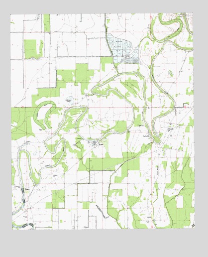
Gilleyville, LA USGS Topographic Map
Click on map above to begin viewing in our Map Viewer.

This topographic map contains these locations and features:
Feature Name Type Latitude Longitude GNIS ID View Map
Adile CemeteryCemeteryN32.3032°W91.8890°532089View Map
Adile ChurchChurchN32.3065°W91.8932°541247View Map
Amity ChurchChurchN32.3013°W91.9899°532156View Map
Big BrakeSwampN32.3408°W91.8905°533036View Map
Bright Water ChurchChurchN32.3096°W91.9132°541246View Map
BucknerPopulated PlaceN32.3010°W91.9387°543038View Map
Buckner Gas FieldOilfieldN32.2835°W91.9640°548673View Map
Calvary ChurchChurchN32.2568°W91.9051°533638View Map
CharlievillePopulated PlaceN32.3068°W91.9193°543073View Map
Douciere Ferry (historical)CrossingN32.2696°W91.9921°546297View Map
GilleyvillePopulated PlaceN32.3029°W91.8946°543236View Map
Greengrove ChurchChurchN32.2740°W91.9904°535395View Map
Hewitt CemeteryCemeteryN32.2540°W91.9057°535641View Map
Landerneau CemeteryCemeteryN32.2743°W91.9951°541240View Map
Landerneau LandingLocaleN32.2752°W91.9937°546319View Map
Mount Zion ChurchChurchN32.3413°W91.8843°537447View Map
Myers BrakeSwampN32.3218°W91.9801°541243View Map
Myers CemeteryCemeteryN32.3082°W91.9790°541242View Map
Palmetto RidgeRidgeN32.3646°W91.9462°558907View Map
Parish Governing Authority District 9CivilN32.2536°W91.8957°1930280View Map
Persimmon SloughGutN32.2771°W91.9435°538082View Map
Pritchard CemeteryCemeteryN32.2574°W91.9896°541241View Map
Reynolds Ferry (historical)CrossingN32.3243°W91.8890°558909View Map
Saint Johns ChurchChurchN32.3038°W91.9532°538894View Map
Saint Luke ChurchChurchN32.3732°W91.8826°538947View Map
Snake RidgeRidgeN32.2849°W91.9032°539460View Map
Steep BayouStreamN32.3401°W91.9262°541232View Map
The BasinSwampN32.3626°W91.8876°541249View Map
Thomason CemeteryCemeteryN32.2810°W91.9721°539885View Map
Thomason SloughGutN32.2568°W91.9518°539886View Map
Union ChurchChurchN32.3065°W91.9207°541245View Map
Victory ChurchChurchN32.3110°W91.8921°541248View Map
Williamson PondLakeN32.3249°W91.9590°541244View Map
Woodsland Plantation AirportAirportN32.3454°W91.9691°1632852View Map

Note: Coordinates in the location and feature list above are referenced to NAD83 datum.


Copyright (C) 2008-2025 Ryan Niemi / Sunset Dynamics ... All Rights Reserved