TopoQuest Logo
Do you find TopoQuest useful?
Help keep TopoQuest running and adding new maps/features by donating!
Bitcoin:  19c7KJd3qBynnjoSw5npx9KScwjBe4ifkT
Litecoin:  LXs6TkuXGGXo1vDsWCkWVdjQX94eUKd6ui
Home View Maps Find Maps Find Places Resources & Links


Mangham, Louisiana Topographic Map

USGS Map Title: Mangham, LA
USGS Map MRC: 32091C7
DRG (GeoTIFF) Download: o32091c7.tif


Neighboring USGS Topographic Map Quads:


  Crew Lake, LA  
32091D8
 

  Rayville, LA  
32091D7
 

  Bee Bayou, LA  
32091D6
 

  Gilleyville, LA  
32091C8
 

  Mangham, LA  
32091C7
 

  Baskinton, LA  
32091C6
 

  Hebert, LA  
32091B8
 

  Liddieville, LA  
32091B7
 

  Winnsboro, LA  
32091B6


Map MRC Location:

N33°
W92°
N33°
W91°
H8 H7 H6 H5 H4 H3 H2 H1
G8 G7 G6 G5 G4 G3 G2 G1
F8 F7 F6 F5 F4 F3 F2 F1
E8 E7 E6 E5 E4 E3 E2 E1
D8 D7 D6 D5 D4 D3 D2 D1
C8 C7 C6 C5 C4 C3 C2 C1
B8 B7 B6 B5 B4 B3 B2 B1
A8 A7 A6 A5 A4 A3 A2 A1
N32°
W92°
N32°
W91°

Mangham, LA USGS 1:24K Topographic Map Preview:
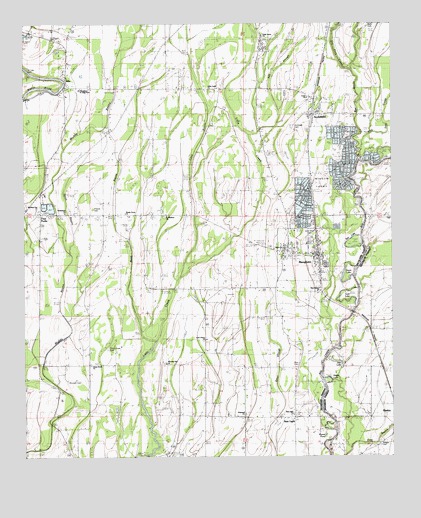
Mangham, LA USGS Topographic Map
Click on map above to begin viewing in our Map Viewer.

This topographic map contains these locations and features:
Feature Name Type Latitude Longitude GNIS ID View Map
AltoPopulated PlaceN32.3576°W91.8599°532147View Map
ArchibaldPopulated PlaceN32.3490°W91.7773°532204View Map
Archibald - Alto Fire StationBuildingN32.3490°W91.7747°2673168View Map
Archibald - Alto Fire StationBuildingN32.3546°W91.8608°2673049View Map
Archibald CemeteryCemeteryN32.3457°W91.7832°532205View Map
Archibald Post OfficePost OfficeN32.3488°W91.7773°1630717View Map
Ash SloughStreamN32.3432°W91.7979°534621View Map
Bee BayouStreamN32.3365°W91.7607°559657View Map
Bell LakeLakeN32.3105°W91.7632°541256View Map
Bethlehem ChurchChurchN32.3207°W91.8610°532992View Map
Big CreekPopulated PlaceN32.2918°W91.7632°542989View Map
Bobby Jones Flying Service Inc Airport (historical)AirportN32.3167°W91.8395°2676798View Map
Brunson CemeteryCemeteryN32.2718°W91.8604°541250View Map
Buie CemeteryCemeteryN32.2771°W91.7818°533521View Map
Caney BayouStreamN32.3026°W91.8207°533727View Map
Cedar ChurchChurchN32.3535°W91.7787°541257View Map
China Grove CemeteryCemeteryN32.2813°W91.8465°533918View Map
China Grove ChurchChurchN32.2765°W91.8526°533920View Map
Dan LakeLakeN32.2776°W91.7682°554256View Map
Dry Fork CreekStreamN32.3613°W91.7551°556510View Map
Four ForksPopulated PlaceN32.3201°W91.8696°541251View Map
Gwin CemeteryCemeteryN32.3746°W91.7554°556458View Map
Gwin Memorial CemeteryCemeteryN32.3138°W91.7782°541255View Map
Hayes LakeLakeN32.2716°W91.7712°554683View Map
Holly Grove ChurchChurchN32.3713°W91.7940°535726View Map
Hopewell ChurchChurchN32.2618°W91.8001°535790View Map
Kelley BayouStreamN32.3032°W91.8212°536158View Map
Little Creek ChurchChurchN32.3560°W91.8118°536535View Map
Long Cherry ChurchChurchN32.2843°W91.8132°536690View Map
ManghamPopulated PlaceN32.3090°W91.7748°536872View Map
Mangham Elementary SchoolSchoolN32.3122°W91.7860°548682View Map
Mangham High SchoolSchoolN32.3099°W91.7860°548683View Map
Mangham Junior High SchoolSchoolN32.3104°W91.7870°541252View Map
Mangham Police DepartmentBuildingN32.3091°W91.7761°2755280View Map
Mangham Volunteer Fire DepartmentBuildingN32.3083°W91.7762°2673113View Map
Morning Star ChurchChurchN32.2774°W91.8265°537227View Map
Morning Star ChurchChurchN32.3215°W91.8710°555480View Map
Mose BayouStreamN32.2838°W91.8304°537242View Map
New Bethel ChurchChurchN32.2979°W91.7746°541254View Map
New LightPopulated PlaceN32.2613°W91.7837°537594View Map
New Light ChurchChurchN32.2626°W91.7840°541253View Map
Otter SloughGutN32.2707°W91.7896°541362View Map
Parish Governing Authority District 7CivilN32.3719°W91.7975°1930202View Map
Persimmon PondLakeN32.2997°W91.8504°555625View Map
Prewitt CemeteryCemeteryN32.3218°W91.8512°538398View Map
Reagan CemeteryCemeteryN32.2543°W91.7543°541260View Map
Richland Alternative SchoolSchoolN32.3481°W91.7782°548691View Map
Round PondLakeN32.2561°W91.7731°555859View Map
Saint Luke CemeteryCemeteryN32.3610°W91.8746°538941View Map
Saint Matthew ChurchChurchN32.3199°W91.8265°538997View Map
Sayre LakeLakeN32.3009°W91.7652°555986View Map
Shady Grove ChurchChurchN32.3204°W91.8407°539279View Map
Spice BayouGutN32.3279°W91.8612°539550View Map
Tank LakeLakeN32.2953°W91.7664°556200View Map
Town of ManghamCivilN32.3090°W91.7795°2406087View Map
Ward FiveCivilN32.2849°W91.8151°545191View Map
Ward FourCivilN32.3699°W91.7712°545190View Map
Wild Dog CreekStreamN32.3468°W91.7529°540395View Map

Note: Coordinates in the location and feature list above are referenced to NAD83 datum.


Copyright (C) 2008-2024 Ryan Niemi / Sunset Dynamics ... All Rights Reserved