TopoQuest Logo
Do you find TopoQuest useful?
Help keep TopoQuest running and adding new maps/features by donating!
Bitcoin:  19c7KJd3qBynnjoSw5npx9KScwjBe4ifkT
Litecoin:  LXs6TkuXGGXo1vDsWCkWVdjQX94eUKd6ui
Home View Maps Find Maps Find Places Resources & Links


Glen Union, Pennsylvania Topographic Map

USGS Map Title: Glen Union, PA
USGS Map MRC: 41077C5
DRG (GeoTIFF) Download: o41077c5.tif


Neighboring USGS Topographic Map Quads:


  Young Womans Creek, PA  
41077D6
 

  Slate Run, PA  
41077D5
 

  Cammal, PA  
41077D4
 

  Renovo East, PA  
41077C6
 

  Glen Union, PA  
41077C5
 

  Jersey Mills, PA  
41077C4
 

  Howard NW, PA  
41077B6
 

  Farrandsville, PA  
41077B5
 

  Lock Haven, PA  
41077B4


Map MRC Location:

N42°
W78°
N42°
W77°
H8 H7 H6 H5 H4 H3 H2 H1
G8 G7 G6 G5 G4 G3 G2 G1
F8 F7 F6 F5 F4 F3 F2 F1
E8 E7 E6 E5 E4 E3 E2 E1
D8 D7 D6 D5 D4 D3 D2 D1
C8 C7 C6 C5 C4 C3 C2 C1
B8 B7 B6 B5 B4 B3 B2 B1
A8 A7 A6 A5 A4 A3 A2 A1
N41°
W78°
N41°
W77°

Glen Union, PA USGS 1:24K Topographic Map Preview:
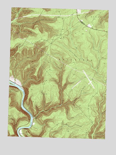
Glen Union, PA USGS Topographic Map
Click on map above to begin viewing in our Map Viewer.

This topographic map contains these locations and features:
Feature Name Type Latitude Longitude GNIS ID View Map
Bear Pen HollowValleyN41.3727°W77.6119°1168896View Map
Bear Pen Hollow TrailTrailN41.3720°W77.5936°1206273View Map
Bear Pen RunStreamN41.3053°W77.6011°1168898View Map
Boyer TrailTrailN41.2676°W77.5389°1206264View Map
Campbell RunStreamN41.3051°W77.5011°1171137View Map
Cleveland HollowValleyN41.3591°W77.6138°1171994View Map
Craig ForkStreamN41.2531°W77.5169°1172598View Map
Cryder TrailTrailN41.3662°W77.5047°1205750View Map
Davis Cabin HollowValleyN41.2841°W77.5426°1172984View Map
Deep HollowValleyN41.2821°W77.5514°1173063View Map
East Branch Hyner RunStreamN41.3615°W77.6222°1173747View Map
First Branch TrailTrailN41.3701°W77.5228°1205747View Map
Flat Ridge TrailTrailN41.2587°W77.5353°1206265View Map
Glen UnionPopulated PlaceN41.2537°W77.6100°1203684View Map
Grandpap HollowValleyN41.2944°W77.6210°1175935View Map
Green RunStreamN41.2956°W77.6111°1176112View Map
Grugan HollowValleyN41.2576°W77.6129°1176293View Map
Hunter HollowValleyN41.2972°W77.5571°1177608View Map
Hyner MountainSummitN41.3467°W77.5644°1177669View Map
Hyner ViewPopulated PlaceN41.3265°W77.6239°1203865View Map
Hyner View State ParkParkN41.3267°W77.6242°1201670View Map
Hyner View TrailTrailN41.3256°W77.6217°1206268View Map
Johnson Ferney TrailTrailN41.2670°W77.5711°1206270View Map
Johnson RunStreamN41.3012°W77.6178°1178120View Map
Lick Run TrailTrailN41.2778°W77.5164°1206262View Map
Long ForkStreamN41.3678°W77.6155°1179850View Map
LucullusPopulated PlaceN41.3690°W77.5400°1204077View Map
Mill RunStreamN41.2501°W77.6094°1181190View Map
Oak Ridge TrailTrailN41.2567°W77.5489°1206266View Map
Park Line TrailTrailN41.2748°W77.5414°1206263View Map
Poff TrailTrailN41.3684°W77.5097°1205749View Map
Ponderosa AirportAirportN41.3080°W77.5234°1194208View Map
Post DraftValleyN41.3520°W77.6116°1184313View Map
Rattlesnake RunStreamN41.2687°W77.5936°1184681View Map
RitchiePopulated PlaceN41.2987°W77.6091°1204515View Map
Ritchie RunStreamN41.2984°W77.6111°1185116View Map
Robbins RunStreamN41.3170°W77.5139°1185201View Map
Robins Ridge TrailTrailN41.3228°W77.5264°1206271View Map
Sinking Spring TrailTrailN41.3401°W77.5103°1206267View Map
Smokestack HollowValleyN41.2748°W77.5847°1187914View Map
Staver RunStreamN41.2742°W77.5058°1188573View Map
Sugar CampLocaleN41.2920°W77.5808°1188923View Map
Township of GruganCivilN41.2689°W77.6055°1216263View Map
Twin Dam HollowValleyN41.2937°W77.5321°1190003View Map
West Branch Lick RunStreamN41.3273°W77.5319°1190912View Map
West Branch Lick Run TrailTrailN41.3362°W77.5505°1206272View Map
WhethamPopulated PlaceN41.2690°W77.5908°1204942View Map
Whetham Fire TowerTowerN41.3151°W77.5716°1213399View Map
Whetham Tower TrailTrailN41.3101°W77.5722°1206269View Map
Wildcat HollowValleyN41.2822°W77.5512°1191407View Map

Note: Coordinates in the location and feature list above are referenced to NAD83 datum.


Copyright (C) 2008-2025 Ryan Niemi / Sunset Dynamics ... All Rights Reserved