TopoQuest Logo
Do you find TopoQuest useful?
Help keep TopoQuest running and adding new maps/features by donating!
Bitcoin:  19c7KJd3qBynnjoSw5npx9KScwjBe4ifkT
Litecoin:  LXs6TkuXGGXo1vDsWCkWVdjQX94eUKd6ui
Home View Maps Find Maps Find Places Resources & Links


Farrandsville, Pennsylvania Topographic Map

USGS Map Title: Farrandsville, PA
USGS Map MRC: 41077B5
DRG (GeoTIFF) Download: o41077b5.tif


Neighboring USGS Topographic Map Quads:


  Renovo East, PA  
41077C6
 

  Glen Union, PA  
41077C5
 

  Jersey Mills, PA  
41077C4
 

  Howard NW, PA  
41077B6
 

  Farrandsville, PA  
41077B5
 

  Lock Haven, PA  
41077B4
 

  Howard, PA  
41077A6
 

  Beech Creek, PA  
41077A5
 

  Mill Hall, PA  
41077A4


Map MRC Location:

N42°
W78°
N42°
W77°
H8 H7 H6 H5 H4 H3 H2 H1
G8 G7 G6 G5 G4 G3 G2 G1
F8 F7 F6 F5 F4 F3 F2 F1
E8 E7 E6 E5 E4 E3 E2 E1
D8 D7 D6 D5 D4 D3 D2 D1
C8 C7 C6 C5 C4 C3 C2 C1
B8 B7 B6 B5 B4 B3 B2 B1
A8 A7 A6 A5 A4 A3 A2 A1
N41°
W78°
N41°
W77°

Farrandsville, PA USGS 1:24K Topographic Map Preview:
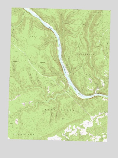
Farrandsville, PA USGS Topographic Map
Click on map above to begin viewing in our Map Viewer.

This topographic map contains these locations and features:
Feature Name Type Latitude Longitude GNIS ID View Map
Baker RunStreamN41.2478°W77.6058°1168607View Map
Baker Run TrailTrailN41.2337°W77.6139°1168608View Map
Bear Wallow HollowValleyN41.1549°W77.5634°1168966View Map
Bird RunStreamN41.1634°W77.5672°1169659View Map
Boiler RunStreamN41.1734°W77.6028°1169950View Map
Boiler Run TrailTrailN41.1842°W77.6153°1169951View Map
Buckhorn HollowValleyN41.1755°W77.5911°1170564View Map
Buckhorn TrailTrailN41.1823°W77.5972°1192213View Map
Dark Hollow TrailTrailN41.2403°W77.5441°1172944View Map
Eagleton RunStreamN41.2317°W77.6192°1173699View Map
East FerneyPopulated PlaceN41.1962°W77.5544°1203472View Map
East Ferney RunStreamN41.1870°W77.5505°1173810View Map
Eravel TrailTrailN41.1970°W77.5244°1192435View Map
FarrandsvillePopulated PlaceN41.1751°W77.5125°1192450View Map
FerneyPopulated PlaceN41.2242°W77.5630°1203563View Map
Ferney RunStreamN41.2245°W77.5644°1174703View Map
Ferney Run TrailTrailN41.2356°W77.5594°1192457View Map
Furnace RunStreamN41.1459°W77.6247°1168006View Map
Goldenrod TrailTrailN41.2234°W77.5247°1206378View Map
Graham RunStreamN41.1690°W77.5314°1175925View Map
Holland RunStreamN41.1870°W77.5542°1177206View Map
Holland Run TrailTrailN41.1887°W77.5808°1192620View Map
King Hollow TrailTrailN41.2278°W77.5491°1192710View Map
Laurel Run ChurchChurchN41.1295°W77.5522°1179025View Map
Left Branch Boiler RunStreamN41.1856°W77.6167°1192761View Map
Lick RunStreamN41.1701°W77.5158°1192780View Map
Little Buckhorn HollowValleyN41.1752°W77.5850°1179487View Map
Little Buckhorn TrailTrailN41.1859°W77.5903°1192792View Map
Little Eagleton RunStreamN41.2242°W77.6225°1179530View Map
Long Hollow TrailTrailN41.2401°W77.5261°1192836View Map
McCloskey RunStreamN41.2251°W77.5678°1180635View Map
McCloskey TrailTrailN41.2151°W77.5822°1206379View Map
North Fork Tangascootack CreekStreamN41.1620°W77.5778°1182589View Map
Peoples ChurchChurchN41.1781°W77.5069°1183569View Map
Plunket Run School (historical)SchoolN41.1295°W77.5325°1197786View Map
River Hollow TrailTrailN41.2009°W77.5764°1206377View Map
RiverviewPopulated PlaceN41.1687°W77.5097°1185145View Map
Round TopSummitN41.1456°W77.5578°1193226View Map
Saltsman RunStreamN41.1931°W77.5450°1186887View Map
State Game Lands Number 89ParkN41.2140°W77.5197°1188540View Map
Sugar Run SchoolSchoolN41.1528°W77.5033°1197787View Map
Tangascootack CreekStreamN41.1781°W77.5475°1189255View Map
Teats RunStreamN41.2415°W77.5928°1189336View Map
Teats Run TrailTrailN41.2348°W77.5983°1193513View Map
Tinsmith HollowValleyN41.1541°W77.5714°1189588View Map
Township of Bald EagleCivilN41.1438°W77.5513°1216253View Map
Township of ColebrookCivilN41.2089°W77.5235°1216257View Map
Twin Springs TrailTrailN41.2445°W77.5508°1193574View Map
Whisky RunStreamN41.1740°W77.5130°1191239View Map

Note: Coordinates in the location and feature list above are referenced to NAD83 datum.


Copyright (C) 2008-2025 Ryan Niemi / Sunset Dynamics ... All Rights Reserved