TopoQuest Logo
Do you find TopoQuest useful?
Help keep TopoQuest running and adding new maps/features by donating!
Bitcoin:  19c7KJd3qBynnjoSw5npx9KScwjBe4ifkT
Litecoin:  LXs6TkuXGGXo1vDsWCkWVdjQX94eUKd6ui
Home View Maps Find Maps Find Places Resources & Links


Renovo East, Pennsylvania Topographic Map

USGS Map Title: Renovo East, PA
USGS Map MRC: 41077C6
DRG (GeoTIFF) Download: o41077c6.tif


Neighboring USGS Topographic Map Quads:


  Tamarack, PA  
41077D7
 

  Young Womans Creek, PA  
41077D6
 

  Slate Run, PA  
41077D5
 

  Renovo West, PA  
41077C7
 

  Renovo East, PA  
41077C6
 

  Glen Union, PA  
41077C5
 

  Snow Shoe NE, PA  
41077B7
 

  Howard NW, PA  
41077B6
 

  Farrandsville, PA  
41077B5


Map MRC Location:

N42°
W78°
N42°
W77°
H8 H7 H6 H5 H4 H3 H2 H1
G8 G7 G6 G5 G4 G3 G2 G1
F8 F7 F6 F5 F4 F3 F2 F1
E8 E7 E6 E5 E4 E3 E2 E1
D8 D7 D6 D5 D4 D3 D2 D1
C8 C7 C6 C5 C4 C3 C2 C1
B8 B7 B6 B5 B4 B3 B2 B1
A8 A7 A6 A5 A4 A3 A2 A1
N41°
W78°
N41°
W77°

Renovo East, PA USGS 1:24K Topographic Map Preview:
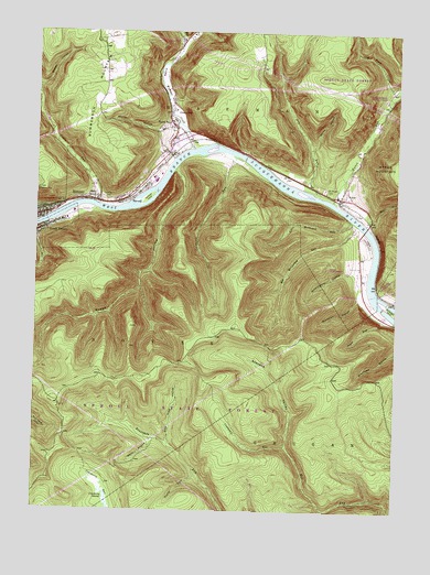
Renovo East, PA USGS Topographic Map
Click on map above to begin viewing in our Map Viewer.

This topographic map contains these locations and features:
Feature Name Type Latitude Longitude GNIS ID View Map
Big McCloskey RunStreamN41.3248°W77.6378°1169534View Map
Boggs HollowValleyN41.3388°W77.7016°1169939View Map
Borough of South RenovoCivilN41.3245°W77.7429°1215120View Map
Bucktail Medical CenterHospitalN41.3279°W77.7365°2718005View Map
Caldwell RunStreamN41.3426°W77.6803°1170874View Map
Caldwell Run TrailTrailN41.3162°W77.6914°1206362View Map
Chapman Township Volunteer Fire Company Station 27BuildingN41.3485°W77.7002°2645845View Map
Chuck Keiper TrailTrailN41.2667°W77.7030°1206261View Map
Citizens Hose Company Station 28BuildingN41.3247°W77.7450°2645057View Map
Crabapple RunStreamN41.2670°W77.6619°1172583View Map
Cranberry SwampSwampN41.2527°W77.7241°1172635View Map
Cranberry Swamp Natural AreaAreaN41.2534°W77.7247°1201681View Map
Dry RunStreamN41.3328°W77.6533°1173547View Map
Fairview CemeteryCemeteryN41.3321°W77.7266°1174501View Map
FarwellPopulated PlaceN41.3328°W77.7144°1174635View Map
GleasontonPopulated PlaceN41.3542°W77.7030°1203677View Map
Goodman HollowValleyN41.3055°W77.6377°1175811View Map
Green RunStreamN41.2998°W77.6278°1214679View Map
Green Run TrailTrailN41.2934°W77.6383°1206323View Map
Huff RunStreamN41.3251°W77.6353°1177558View Map
HynerPopulated PlaceN41.3317°W77.6442°1177668View Map
Hyner Landing Field (historical)AirportN41.3317°W77.6444°1213237View Map
Hyner RunStreamN41.3309°W77.6467°1192655View Map
Hyner Run State ParkParkN41.3592°W77.6330°1198255View Map
Left Branch Young Womans CreekStreamN41.3710°W77.6998°1199896View Map
Little McCloskey RunStreamN41.3259°W77.6397°1179595View Map
Little McCloskey TrailTrailN41.3223°W77.6775°1206363View Map
Log Road HollowValleyN41.3609°W77.6272°1179808View Map
McCloskey IslandIslandN41.3031°W77.6264°1180633View Map
North BendPopulated PlaceN41.3501°W77.7022°1204297View Map
North Bend Post OfficePost OfficeN41.3506°W77.7024°2772885View Map
Paddy RunStreamN41.3301°W77.7283°1183183View Map
Pennsylvania Department of Environmental Services Hyner Run Maintenance DivisionBuildingN41.3584°W77.6287°2645589View Map
Renovo Fire Department Station 29BuildingN41.3266°W77.7477°2645068View Map
Renovo ViewLocaleN41.3334°W77.7489°1184904View Map
Saint Josephs CemeteryCemeteryN41.3341°W77.6500°1186226View Map
Schoolhouse HollowValleyN41.3125°W77.6379°1187109View Map
Skunk HollowValleyN41.3500°W77.7038°1187765View Map
Sled Road HollowValleyN41.2678°W77.7026°1187800View Map
South RenovoPopulated PlaceN41.3231°W77.7483°1188102View Map
Stevens ValleyValleyN41.2671°W77.6618°1188639View Map
Stone HollowValleyN41.3454°W77.6541°1188722View Map
Tamarack IslandIslandN41.3315°W77.7111°1189244View Map
Taylor ForkStreamN41.2598°W77.6933°1189305View Map
Weaver HollowValleyN41.3608°W77.7495°1190739View Map
Wertz HollowValleyN41.2683°W77.7088°1190846View Map
Young Womans CreekStreamN41.3442°W77.6958°1199826View Map

Note: Coordinates in the location and feature list above are referenced to NAD83 datum.


Copyright (C) 2008-2024 Ryan Niemi / Sunset Dynamics ... All Rights Reserved