TopoQuest Logo
Do you find TopoQuest useful?
Help keep TopoQuest running and adding new maps/features by donating!
Bitcoin:  19c7KJd3qBynnjoSw5npx9KScwjBe4ifkT
Litecoin:  LXs6TkuXGGXo1vDsWCkWVdjQX94eUKd6ui
Home View Maps Find Maps Find Places Resources & Links


Glencoe, Minnesota Topographic Map

USGS Map Title: Glencoe, MN
USGS Map MRC: 44094G2
DRG (GeoTIFF) Download: o44094g2.tif


Neighboring USGS Topographic Map Quads:


  Hutchinson East, MN  
44094H3
 

  Silver Lake, MN  
44094H2
 

  Winsted, MN  
44094H1
 

  Biscay, MN  
44094G3
 

  Glencoe, MN  
44094G2
 

  Plato, MN  
44094G1
 

  Brownton, MN  
44094F3
 

  New Auburn, MN  
44094F2
 

  Green Isle, MN  
44094F1


Map MRC Location:

N45°
W95°
N45°
W94°
H8 H7 H6 H5 H4 H3 H2 H1
G8 G7 G6 G5 G4 G3 G2 G1
F8 F7 F6 F5 F4 F3 F2 F1
E8 E7 E6 E5 E4 E3 E2 E1
D8 D7 D6 D5 D4 D3 D2 D1
C8 C7 C6 C5 C4 C3 C2 C1
B8 B7 B6 B5 B4 B3 B2 B1
A8 A7 A6 A5 A4 A3 A2 A1
N44°
W95°
N44°
W94°

Glencoe, MN USGS 1:24K Topographic Map Preview:
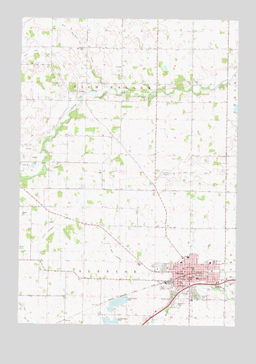
Glencoe, MN USGS Topographic Map
Click on map above to begin viewing in our Map Viewer.

This topographic map contains these locations and features:
Feature Name Type Latitude Longitude GNIS ID View Map
Anderson CourtPopulated PlaceN44.7708°W94.1414°2065245View Map
Baker Elementary SchoolSchoolN44.7757°W94.1564°663165View Map
Barber LakeSwampN44.8120°W94.1640°1817776View Map
Bear CreekStreamN44.8450°W94.2011°663166View Map
Bear Creek CemeteryCemeteryN44.8627°W94.2137°663167View Map
Beihoffer LakeLakeN44.7670°W94.1524°1817768View Map
Berean Baptist ChurchChurchN44.7756°W94.1517°2065256View Map
Bog LakebedFlatN44.7791°W94.1961°1817774View Map
Christ Lutheran ChurchChurchN44.7789°W94.1469°2065255View Map
Church of PeaceChurchN44.7700°W94.1547°2065251View Map
City of GlencoeCivilN44.7702°W94.1491°2394912View Map
County Ditch Number Twelve ACanalN44.7555°W94.2455°1817791View Map
County Ditch Number TwentysixCanalN44.8580°W94.2350°1817780View Map
First Congregational ChurchChurchN44.7736°W94.1553°2065249View Map
First Lutheran ChurchChurchN44.7728°W94.1497°2065254View Map
First Lutheran SchoolSchoolN44.7736°W94.1487°1817770View Map
Getchell CemeteryCemeteryN44.7938°W94.2475°663169View Map
Glen Knoll Mobile Home ParkPopulated PlaceN44.7750°W94.1694°2065265View Map
GlencoeLocaleN44.7708°W94.1542°2065248View Map
GlencoePopulated PlaceN44.7691°W94.1516°663170View Map
Glencoe - Silver Lake Senior High SchoolSchoolN44.7762°W94.1376°2065264View Map
Glencoe Christian ChurchChurchN44.7692°W94.1514°2065252View Map
Glencoe City LibraryBuildingN44.7725°W94.1517°2065241View Map
Glencoe Country ClubLocaleN44.7617°W94.1431°2065262View Map
Glencoe Fire DepartmentBuildingN44.7693°W94.1553°2065242View Map
Glencoe Fort Historical MarkerParkN44.7686°W94.1264°2065384View Map
Glencoe Medical ClinicHospitalN44.7778°W94.1553°2065258View Map
Glencoe Police DepartmentBuildingN44.7684°W94.1534°2065243View Map
Glencoe Post OfficePost OfficeN44.7703°W94.1502°2065259View Map
Glencoe Regional Health Services HospitalHospitalN44.7779°W94.1527°2065257View Map
Good Shepherd Lutheran ChurchChurchN44.7736°W94.1572°2065250View Map
Henry Hill Intermediate SchoolSchoolN44.7708°W94.1475°2065263View Map
Hillcrest CemeteryCemeteryN44.7623°W94.1624°1817772View Map
KoniskaPopulated PlaceN44.8450°W94.2175°2065366View Map
KoniskaPopulated PlaceN44.8450°W94.2169°1817777View Map
Koniska CemeteryCemeteryN44.8444°W94.2202°663171View Map
Koniska Post Office (historical)Post OfficeN44.8450°W94.2175°2065367View Map
Lincoln Junior High SchoolSchoolN44.7758°W94.1399°1817771View Map
Lincoln ParkParkN44.7675°W94.1550°1817701View Map
McLeod County CourthouseBuildingN44.7700°W94.1503°2065261View Map
McLeod County JailBuildingN44.7694°W94.1511°2758824View Map
McLeod County Sheriff's OfficeBuildingN44.7693°W94.1510°2065260View Map
Oak Leaf ParkParkN44.7583°W94.1586°663172View Map
Perez Mobile Home ParkPopulated PlaceN44.7714°W94.1444°2065246View Map
Saint Pius X Catholic ChurchChurchN44.7700°W94.1469°2065253View Map
Saint Pius X Catholic SchoolSchoolN44.7695°W94.1472°1817769View Map
School Number 1011SchoolN44.7908°W94.1830°663173View Map
School Number 996SchoolN44.8297°W94.1511°663174View Map
Sunrise CourtPopulated PlaceN44.7719°W94.1428°2065247View Map
Swan LakebedFlatN44.7872°W94.2344°1817775View Map
Township of GlencoeCivilN44.7607°W94.1964°664277View Map
Township of Rich ValleyCivilN44.8486°W94.1927°665417View Map

Note: Coordinates in the location and feature list above are referenced to NAD83 datum.


Copyright (C) 2008-2024 Ryan Niemi / Sunset Dynamics ... All Rights Reserved