TopoQuest Logo
Do you find TopoQuest useful?
Help keep TopoQuest running and adding new maps/features by donating!
Bitcoin:  19c7KJd3qBynnjoSw5npx9KScwjBe4ifkT
Litecoin:  LXs6TkuXGGXo1vDsWCkWVdjQX94eUKd6ui
Home View Maps Find Maps Find Places Resources & Links


Glendale, Texas Topographic Map

USGS Map Title: Glendale, TX
USGS Map MRC: 31095A3
DRG (GeoTIFF) Download: o31095a3.tif


Neighboring USGS Topographic Map Quads:


  Lovelady North, TX  
31095B4
 

  Fodice, TX  
31095B3
 

  Pennington, TX  
31095B2
 

  Lovelady South, TX  
31095A4
 

  Glendale, TX  
31095A3
 

  Groveton West, TX  
31095A2
 

  Trinity West, TX  
30095H4
 

  Trinity East, TX  
30095H3
 

  Chita, TX  
30095H2


Map MRC Location:

N32°
W96°
N32°
W95°
H8 H7 H6 H5 H4 H3 H2 H1
G8 G7 G6 G5 G4 G3 G2 G1
F8 F7 F6 F5 F4 F3 F2 F1
E8 E7 E6 E5 E4 E3 E2 E1
D8 D7 D6 D5 D4 D3 D2 D1
C8 C7 C6 C5 C4 C3 C2 C1
B8 B7 B6 B5 B4 B3 B2 B1
A8 A7 A6 A5 A4 A3 A2 A1
N31°
W96°
N31°
W95°

Glendale, TX USGS 1:24K Topographic Map Preview:
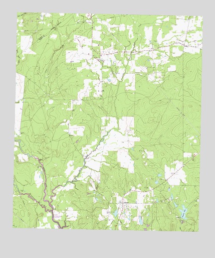
Glendale, TX USGS Topographic Map
Click on map above to begin viewing in our Map Viewer.

This topographic map contains these locations and features:
Feature Name Type Latitude Longitude GNIS ID View Map
Adams LakeReservoirN31.0085°W95.3052°1855233View Map
Adams Lake DamDamN31.0085°W95.3052°1855232View Map
Anderson CemeteryCemeteryN31.1099°W95.2799°1351099View Map
Cameron LakeReservoirN31.0109°W95.2604°1353600View Map
FridayPopulated PlaceN31.1085°W95.2630°2034915View Map
FridayPopulated PlaceN31.1082°W95.2622°1379803View Map
GlendalePopulated PlaceN31.0157°W95.3011°1358055View Map
Glendale CemeteryCemeteryN31.0105°W95.3105°1358057View Map
Glendale DivisionCivilN31.0264°W95.3239°1938783View Map
Holly CemeteryCemeteryN31.1202°W95.3322°1359436View Map
Lake DawsonReservoirN31.0057°W95.2891°1855235View Map
Lake Dawson DamDamN31.0035°W95.2885°1855234View Map
Little White Rock CreekStreamN31.0141°W95.3502°1382187View Map
SaronPopulated PlaceN31.0357°W95.2641°2034912View Map
Saron CemeteryCemeteryN31.0174°W95.2738°1367784View Map
Saron Lake Number 1 DamDamN31.0085°W95.2619°1855236View Map
Saron Lake Number 2ReservoirN31.0154°W95.2659°1855239View Map
Saron Lake Number 2 DamDamN31.0152°W95.2652°1855238View Map
Saron Lake Number 3ReservoirN31.0198°W95.2684°1855241View Map
Saron Lake Number 3 DamDamN31.0185°W95.2685°1855240View Map
Saron Lake Number 4ReservoirN31.0243°W95.2704°1855243View Map
Saron Lake Number 4 DamDamN31.0235°W95.2702°1855242View Map
Saron Lake Number 6ReservoirN31.0219°W95.2602°1855245View Map
Saron Lake Number 6 DamDamN31.0219°W95.2602°1855244View Map
Saron Lake Number 7ReservoirN31.0152°W95.2552°1855247View Map
Saron Lake Number 7 DamDamN31.0152°W95.2552°1855246View Map
Tantabogue CreekStreamN31.0105°W95.3491°1372208View Map
Thompson SchoolSchoolN31.0982°W95.3161°1369857View Map
Thornton ChurchChurchN31.0460°W95.2874°1369867View Map
Trilady ParkParkN31.0360°W95.3566°1370116View Map
Zion Hill ChurchChurchN31.0907°W95.3077°1372098View Map

Note: Coordinates in the location and feature list above are referenced to NAD83 datum.


Copyright (C) 2008-2025 Ryan Niemi / Sunset Dynamics ... All Rights Reserved