TopoQuest Logo
Do you find TopoQuest useful?
Help keep TopoQuest running and adding new maps/features by donating!
Bitcoin:  19c7KJd3qBynnjoSw5npx9KScwjBe4ifkT
Litecoin:  LXs6TkuXGGXo1vDsWCkWVdjQX94eUKd6ui
Home View Maps Find Maps Find Places Resources & Links


Glendale, Tennessee Topographic Map

USGS Map Title: Glendale, TN
USGS Map MRC: 35086E8
DRG (GeoTIFF) Download: o35086e8.tif


Neighboring USGS Topographic Map Quads:


  Godwin, TN  
35087F1
 

  Carters Creek, TN  
35086F8
 

  Rally Hill, TN  
35086F7
 

  Columbia, TN  
35087E1
 

  Glendale, TN  
35086E8
 

  Verona, TN  
35086E7
 

  Lynnville, TN  
35087D1
 

  Campbells Station, TN  
35086D8
 

  Lewisburg, TN  
35086D7


Map MRC Location:

N36°
W87°
N36°
W86°
H8 H7 H6 H5 H4 H3 H2 H1
G8 G7 G6 G5 G4 G3 G2 G1
F8 F7 F6 F5 F4 F3 F2 F1
E8 E7 E6 E5 E4 E3 E2 E1
D8 D7 D6 D5 D4 D3 D2 D1
C8 C7 C6 C5 C4 C3 C2 C1
B8 B7 B6 B5 B4 B3 B2 B1
A8 A7 A6 A5 A4 A3 A2 A1
N35°
W87°
N35°
W86°

Glendale, TN USGS 1:24K Topographic Map Preview:
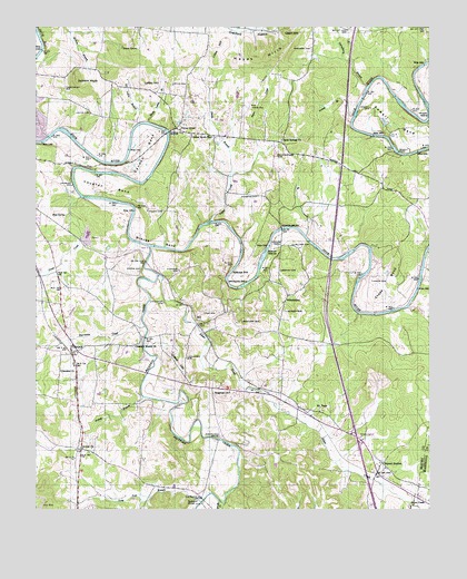
Glendale, TN USGS Topographic Map
Click on map above to begin viewing in our Map Viewer.

This topographic map contains these locations and features:
Feature Name Type Latitude Longitude GNIS ID View Map
Alf Loftin BranchStreamN35.5990°W86.9689°1275566View Map
Andrews CemeteryCemeteryN35.5812°W86.9292°1275738View Map
Atkinson CemeteryCemeteryN35.5623°W86.9547°1304894View Map
Beech GrovePopulated PlaceN35.6198°W86.9725°1314647View Map
Blue SpringSpringN35.5762°W86.9906°1277782View Map
Blue Spring ChurchChurchN35.5781°W86.9961°1305308View Map
Bowman CemeteryCemeteryN35.5120°W86.9467°1646140View Map
Branch CemeteryCemeteryN35.5620°W86.9219°1278225View Map
Branch IslandsIslandN35.5687°W86.9225°1278227View Map
Brush CreekStreamN35.5020°W86.9414°1305473View Map
Bryant StationPopulated PlaceN35.5117°W86.8894°1278757View Map
Bryant Station CemeteryCemeteryN35.5106°W86.8886°1646149View Map
Bryant Station School (historical)SchoolN35.5120°W86.8908°1323670View Map
Buzzard RoostSummitN35.5023°W86.9522°1279223View Map
Cannon BendBendN35.5920°W86.9658°1279603View Map
Caruthers Mill (historical)LocaleN35.5023°W86.9467°1646157View Map
Cedar CreekStreamN35.5628°W86.8764°1305754View Map
Central CemeteryCemeteryN35.5162°W86.9850°1646163View Map
Central ChurchChurchN35.5159°W86.9853°1305816View Map
Cheatham Mill (historical)LocaleN35.5431°W86.9661°1323676View Map
Cheek BendBendN35.5598°W86.8872°1305871View Map
Cheek CemeteryCemeteryN35.5592°W86.8928°1280313View Map
Commissioner District 8CivilN35.5481°W86.9315°2464690View Map
Cranford CemeteryCemeteryN35.6190°W86.9292°1646186View Map
Crews HillSummitN35.5381°W86.9558°1281613View Map
Cuba (historical)Populated PlaceN35.5062°W86.9622°1646190View Map
Cuba School (historical)SchoolN35.5062°W86.9586°1323683View Map
Davidson CemeteryCemeteryN35.5487°W86.9344°1306273View Map
Davis FordCrossingN35.5256°W86.9572°1646193View Map
Davis-Mitchell CemeteryCemeteryN35.6198°W86.9725°1646194View Map
Derryberry BranchStreamN35.6098°W86.8947°1282367View Map
Dillehay CemeteryCemeteryN35.5348°W86.9433°1646198View Map
District 24 (historical)CivilN35.6001°W86.9167°1310233View Map
District 4 (historical)CivilN35.5251°W86.9167°1310213View Map
District 5 (historical)CivilN35.5417°W86.9667°1310214View Map
Edmondson BridgeBridgeN35.5181°W86.9419°1283535View Map
Farrar CemeteryCemeteryN35.6134°W86.9119°1646210View Map
Fountain CreekStreamN35.5681°W86.9636°1284709View Map
Fountain Creek Station (historical)LocaleN35.5598°W86.9586°1323694View Map
Fountain HeightsPopulated PlaceN35.5448°W86.9664°1284714View Map
Fountain Heights Division (historical)CensusN35.5256°W86.9075°1648869View Map
Fountain Heights School (historical)SchoolN35.5456°W86.9661°1323695View Map
Gilliam CemeteryCemeteryN35.5684°W86.9181°1306482View Map
GlendalePopulated PlaceN35.5406°W86.9886°1306487View Map
Glendale ChurchChurchN35.5359°W86.9922°1306488View Map
Glendale FieldAirportN35.5332°W86.9770°2675504View Map
Goose CreekStreamN35.5009°W86.8806°1285670View Map
Goose CreekStreamN35.5809°W86.9856°1285671View Map
Greasy BranchStreamN35.5290°W86.9653°1286035View Map
Griffin-Love CemeteryCemeteryN35.5470°W86.9619°1646247View Map
Hardison CemeteryCemeteryN35.6195°W86.9119°1286847View Map
Hardison CemeteryCemeteryN35.6084°W86.9147°1646254View Map
Harris CemeteryCemeteryN35.5626°W86.9667°1286959View Map
Harris CrossroadsLocaleN35.5159°W86.9856°1646256View Map
Hayes HillsSummitN35.6167°W86.9300°1287222View Map
HillPopulated PlaceN35.5481°W86.9486°1306570View Map
Hill CemeteryCemeteryN35.5509°W86.9467°1287784View Map
Holland CemeteryCemeteryN35.5692°W86.9381°1646266View Map
Holland FordCrossingN35.5745°W86.9442°1646267View Map
Hooper IslandIslandN35.6026°W86.8750°1288252View Map
Hopewell ChurchChurchN35.5306°W86.9383°1288306View Map
Howard BridgeBridgeN35.5728°W86.9217°1288524View Map
Howard CemeteryCemeteryN35.5687°W86.9225°1288528View Map
Hurricane CreekStreamN35.5476°W86.9653°1288806View Map
Interchange 37CrossingN35.5190°W86.8981°1313228View Map
Jackson KnobSummitN35.6115°W86.9872°1289235View Map
Lancaster CemeteryCemeteryN35.5392°W86.9522°1290570View Map
Lancaster CemeteryCemeteryN35.5537°W86.9592°1290571View Map
Lickskillet (historical)Populated PlaceN35.5617°W86.9033°1313236View Map
Lindsey CemeteryCemeteryN35.5242°W86.9897°1646304View Map
Lindseys CrossroadsLocaleN35.5270°W86.9867°1646305View Map
Little HillSummitN35.6173°W86.9422°1291527View Map
Loftin CemeteryCemeteryN35.6028°W86.9828°1291807View Map
Loftin CemeteryCemeteryN35.6101°W86.9561°1291808View Map
Loftin HillSummitN35.6106°W86.9658°1291809View Map
Long Tom BranchStreamN35.5020°W86.9478°1292012View Map
Mount TemaPopulated PlaceN35.5265°W86.9097°1313515View Map
Mount Tema ChurchChurchN35.5259°W86.9086°1294808View Map
Mule Patch Airport (historical)AirportN35.6023°W86.9328°1301354View Map
Nancy BranchStreamN35.6017°W86.8992°1306811View Map
Negro CreekStreamN35.5751°W86.9444°1295334View Map
Oak Hill School (historical)SchoolN35.5459°W86.9581°1324869View Map
Park StationPopulated PlaceN35.5267°W86.9167°1306878View Map
Park Station School (historical)SchoolN35.5256°W86.9089°1324871View Map
PhiladelphiaPopulated PlaceN35.5556°W86.9197°1315704View Map
Philadelphia CemeteryCemeteryN35.5540°W86.9211°1646495View Map
Philadelphia ChurchChurchN35.5537°W86.9214°1646496View Map
Philadelphia School (historical)SchoolN35.5545°W86.9211°1324874View Map
Pleasant Mount CemeteryCemeteryN35.5417°W86.9683°1646501View Map
Pleasant Mount ChurchChurchN35.5423°W86.9686°1306906View Map
Primms CornerLocaleN35.5787°W86.9161°1324883View Map
Puckett CemeteryCemeteryN35.5215°W86.9158°1646507View Map
Rieves BendBendN35.5734°W86.9606°1306951View Map
Rieves CemeteryCemeteryN35.5776°W86.9644°1299421View Map
Rock SpringsPopulated PlaceN35.5951°W86.9217°1647720View Map
Rock Springs CemeteryCemeteryN35.5917°W86.9233°1299798View Map
Rock Springs ChurchChurchN35.5959°W86.9217°1306965View Map
ScribnerPopulated PlaceN35.5017°W86.9461°1315884View Map
Scribners Mill BridgeBridgeN35.5026°W86.9469°1300974View Map
Sewell CemeteryCemeteryN35.5131°W86.9811°1646533View Map
Shade Loftin BranchStreamN35.6006°W86.9642°1301149View Map
Silver CreekStreamN35.5609°W86.9608°1270275View Map
Smith BranchStreamN35.5865°W86.9381°1270560View Map
Smith CemeteryCemeteryN35.5523°W86.9839°1646541View Map
Sowell BendBendN35.5990°W86.8839°1270930View Map
Sowell CemeteryCemeteryN35.6042°W86.8933°1270934View Map
Sowell FordPopulated PlaceN35.5926°W86.8847°1314315View Map
Sowell Mill BridgeBridgeN35.5978°W86.9578°1270936View Map
Sowells Mills (historical)LocaleN35.5981°W86.9575°1324898View Map
Stillhouse HoleLocaleN35.5615°W86.9378°1271406View Map
Tankersley CemeteryCemeteryN35.6092°W86.9908°1303998View Map
Undeerwood CemeteryCemeteryN35.6240°W86.8786°1646565View Map
Union GrovePopulated PlaceN35.5990°W86.9553°1273216View Map
Union Grove ChurchChurchN35.6001°W86.9539°1324908View Map
Union Grove SchoolSchoolN35.5967°W86.9442°1304245View Map
Vaughan BendBendN35.5837°W86.9764°1273401View Map
Vaughan CemeteryCemeteryN35.5842°W86.9886°1273403View Map
Watson CemeteryCemeteryN35.5512°W86.9203°1273919View Map
Watson CemeteryCemeteryN35.5081°W86.9008°1646572View Map
Whitworth BendBendN35.5662°W86.9314°1274505View Map
WMCP-AM (Columbia)TowerN35.6190°W86.9811°1639874View Map

Note: Coordinates in the location and feature list above are referenced to NAD83 datum.


Copyright (C) 2008-2024 Ryan Niemi / Sunset Dynamics ... All Rights Reserved