TopoQuest Logo
Do you find TopoQuest useful?
Help keep TopoQuest running and adding new maps/features by donating!
Bitcoin:  19c7KJd3qBynnjoSw5npx9KScwjBe4ifkT
Litecoin:  LXs6TkuXGGXo1vDsWCkWVdjQX94eUKd6ui
Home View Maps Find Maps Find Places Resources & Links


Lynnville, Tennessee Topographic Map

USGS Map Title: Lynnville, TN
USGS Map MRC: 35087D1
DRG (GeoTIFF) Download: o35087d1.tif


Neighboring USGS Topographic Map Quads:


  Mount Pleasant, TN  
35087E2
 

  Columbia, TN  
35087E1
 

  Glendale, TN  
35086E8
 

  Sandy Hook, TN  
35087D2
 

  Lynnville, TN  
35087D1
 

  Campbells Station, TN  
35086D8
 

  Campbellsville, TN  
35087C2
 

  Milky Way, TN  
35087C1
 

  Brick Church, TN  
35086C8


Map MRC Location:

N36°
W88°
N36°
W87°
H8 H7 H6 H5 H4 H3 H2 H1
G8 G7 G6 G5 G4 G3 G2 G1
F8 F7 F6 F5 F4 F3 F2 F1
E8 E7 E6 E5 E4 E3 E2 E1
D8 D7 D6 D5 D4 D3 D2 D1
C8 C7 C6 C5 C4 C3 C2 C1
B8 B7 B6 B5 B4 B3 B2 B1
A8 A7 A6 A5 A4 A3 A2 A1
N35°
W88°
N35°
W87°

Lynnville, TN USGS 1:24K Topographic Map Preview:
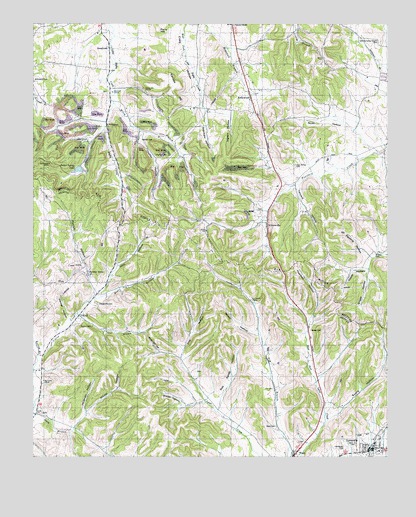
Lynnville, TN USGS Topographic Map
Click on map above to begin viewing in our Map Viewer.

This topographic map contains these locations and features:
Feature Name Type Latitude Longitude GNIS ID View Map
Akers-Brown CemeteryCemeteryN35.4534°W87.0175°1646109View Map
Badger Spring LakeReservoirN35.4579°W87.1092°1301857View Map
Badget SpringSpringN35.4580°W87.1103°1646123View Map
Bethel ChurchChurchN35.4665°W87.1058°1305130View Map
Big CreekPopulated PlaceN35.3973°W87.1222°1313201View Map
Big Creek ChurchChurchN35.3970°W87.1211°1277284View Map
Blue BranchStreamN35.4212°W87.1033°1277746View Map
Bob Sands HollowValleyN35.3907°W87.0591°1305330View Map
Booker CemeteryCemeteryN35.4723°W87.0086°1646138View Map
Braden CemeteryCemeteryN35.4337°W87.0042°1278146View Map
Braden HollowValleyN35.3901°W87.0714°1278152View Map
Braggs GapGapN35.4134°W87.0100°1313202View Map
BroadviewPopulated PlaceN35.4931°W87.0981°1278436View Map
Brown CemeteryCemeteryN35.4117°W87.0267°1278526View Map
Chaffin CemeteryCemeteryN35.4762°W87.1219°1646164View Map
Chaffin CemeteryCemeteryN35.4623°W87.0819°1280193View Map
Chaffin HollowValleyN35.4686°W87.0861°1305838View Map
Chapel BranchStreamN35.4159°W87.1106°1280246View Map
Culleoka Division (historical)CensusN35.4734°W87.0144°1648868View Map
Dog HollowValleyN35.4037°W87.0730°1282592View Map
Dugger HollowValleyN35.4688°W87.0851°1313219View Map
Evans HollowValleyN35.3975°W87.0240°1313203View Map
Evans HollowValleyN35.3861°W87.0207°1283909View Map
Fairview ChurchChurchN35.4998°W87.0542°1284008View Map
Fleming HollowValleyN35.4324°W87.0054°1284461View Map
Foster CemeteryCemeteryN35.4465°W87.0458°1646219View Map
Foster HollowValleyN35.4293°W87.0071°1284703View Map
Fry Branch ChurchChurchN35.4204°W87.0481°1284991View Map
Fry Branch School (historical)SchoolN35.4204°W87.0483°1323619View Map
Fry CemeteryCemeteryN35.3945°W87.0400°1284993View Map
Garrett CemeteryCemeteryN35.4667°W87.0867°1285187View Map
Giles County Fire and Rescue Squad LynnvilleBuildingN35.3772°W87.0021°2654258View Map
Gilmer CemeteryCemeteryN35.4748°W87.0819°1646235View Map
Gilmer Hill ChurchChurchN35.4812°W87.0861°1285425View Map
Gilmer HollowValleyN35.4812°W87.0952°1313222View Map
GipsonvillePopulated PlaceN35.4220°W87.1025°1313204View Map
Gipsonville CemeteryCemeteryN35.4192°W87.1022°1285462View Map
Gipsonville School (historical)SchoolN35.4212°W87.1025°1323620View Map
Glenwood CemeteryCemeteryN35.4801°W87.0986°1646237View Map
Glenwood ChurchChurchN35.4804°W87.0970°1306490View Map
Gooch CemeteryCemeteryN35.4509°W87.1161°1646241View Map
Griggs HollowValleyN35.4260°W87.0063°1286295View Map
Grigsby School (historical)SchoolN35.3992°W87.0692°1323621View Map
Hickman HillSummitN35.4090°W87.0839°1287559View Map
Hickmans GapGapN35.4312°W87.0583°1313205View Map
Hindman HollowValleyN35.3882°W87.1065°1287867View Map
Hogan CemeteryCemeteryN35.4412°W87.0564°1646265View Map
HollywoodPopulated PlaceN35.4784°W87.0481°1288120View Map
Horn HollowValleyN35.4231°W87.1004°1288357View Map
Howard CemeteryCemeteryN35.4809°W87.0508°1646271View Map
Howells Mill BranchStreamN35.4695°W87.1003°1313227View Map
Hubbell CemeteryCemeteryN35.4573°W87.1136°1646275View Map
Ingram HollowValleyN35.4736°W87.0553°1289013View Map
Ingram SpringSpringN35.4615°W87.0206°1646282View Map
Kansas HillSummitN35.4823°W87.0750°1306644View Map
Kennell HollowValleyN35.4152°W87.1121°1290082View Map
Lee CemeteryCemeteryN35.4723°W87.0469°1646300View Map
Logue CemeteryCemeteryN35.4867°W87.0978°1646311View Map
LynnvillePopulated PlaceN35.3767°W87.0061°1292366View Map
Lynnville First Baptist ChurchChurchN35.3762°W87.0086°1646085View Map
Lynnville Police DepartmentBuildingN35.3767°W87.0065°2765782View Map
Lynnville Post OfficePost OfficeN35.3770°W87.0035°1652197View Map
Lynnwood CemeteryCemeteryN35.3767°W87.0144°1292368View Map
Matthews CemeteryCemeteryN35.4626°W87.0958°1646456View Map
McKissick BranchStreamN35.4995°W87.0981°1313512View Map
McKissick CemeteryCemeteryN35.4840°W87.1247°1293387View Map
McKnight CemeteryCemeteryN35.4690°W87.0911°1646462View Map
Meriday HollowValleyN35.4115°W87.1129°1313206View Map
Mill HollowValleyN35.4691°W87.1004°1293868View Map
Millers Lake DamDamN35.4584°W87.1083°1301858View Map
Moore ChapelChurchN35.4742°W87.0478°1294280View Map
Moore Chapel (historical)ChurchN35.4742°W87.0481°1324861View Map
Morrow BranchStreamN35.4029°W87.1231°1294458View Map
New Ramah Church (historical)ChurchN35.4587°W87.0328°1646485View Map
New Ramey CemeteryCemeteryN35.4592°W87.0328°1306827View Map
Nubbins GapGapN35.4284°W87.0367°1313207View Map
Old Camping Ground CemeteryCemeteryN35.4945°W87.0025°1306858View Map
Parrish HollowValleyN35.4221°W87.1029°1296882View Map
Perry-Pillow CemeteryCemeteryN35.4909°W87.0911°1646494View Map
RichPopulated PlaceN35.3873°W87.1236°1315801View Map
Richalnd High SchoolSchoolN35.3767°W87.0028°1323623View Map
Richardson CemeteryCemeteryN35.4542°W87.0342°1646515View Map
Richland Elementary SchoolSchoolN35.3767°W87.0020°1323622View Map
Sands HollowValleyN35.4108°W87.0458°1300724View Map
Scott HollowValleyN35.4639°W87.0056°1307033View Map
SouthportPopulated PlaceN35.4706°W87.0989°1314313View Map
StiversvillePopulated PlaceN35.4423°W87.0422°1303848View Map
Stockard HollowValleyN35.4768°W87.0641°1271455View Map
Sullivan School (historical)SchoolN35.4779°W87.0945°1324905View Map
Tanyard HollowValleyN35.4535°W87.0325°1272110View Map
Taylor ChapelChurchN35.4126°W87.1039°1272222View Map
Thurman HollowValleyN35.4154°W87.0270°1272604View Map
Town of LynnvilleCivilN35.3781°W87.0061°2406067View Map
WacoPopulated PlaceN35.3759°W87.0320°1304314View Map
Waco CemeteryCemeteryN35.3840°W87.0389°1273508View Map
Wells HollowValleyN35.3778°W87.0992°1647693View Map
West Family CemeteryCemeteryN35.4309°W87.0767°2742112View Map
Wilcox HollowValleyN35.3839°W87.1105°1304581View Map
Wiley BranchStreamN35.4770°W87.0964°1274571View Map
YokleyPopulated PlaceN35.4159°W87.1086°1304704View Map

Note: Coordinates in the location and feature list above are referenced to NAD83 datum.


Copyright (C) 2008-2025 Ryan Niemi / Sunset Dynamics ... All Rights Reserved