TopoQuest Logo
Do you find TopoQuest useful?
Help keep TopoQuest running and adding new maps/features by donating!
Bitcoin:  19c7KJd3qBynnjoSw5npx9KScwjBe4ifkT
Litecoin:  LXs6TkuXGGXo1vDsWCkWVdjQX94eUKd6ui
Home View Maps Find Maps Find Places Resources & Links


Campbells Station, Tennessee Topographic Map

USGS Map Title: Campbells Station, TN
USGS Map MRC: 35086D8
DRG (GeoTIFF) Download: o35086d8.tif


Neighboring USGS Topographic Map Quads:


  Columbia, TN  
35087E1
 

  Glendale, TN  
35086E8
 

  Verona, TN  
35086E7
 

  Lynnville, TN  
35087D1
 

  Campbells Station, TN  
35086D8
 

  Lewisburg, TN  
35086D7
 

  Milky Way, TN  
35087C1
 

  Brick Church, TN  
35086C8
 

  Cornersville, TN  
35086C7


Map MRC Location:

N36°
W87°
N36°
W86°
H8 H7 H6 H5 H4 H3 H2 H1
G8 G7 G6 G5 G4 G3 G2 G1
F8 F7 F6 F5 F4 F3 F2 F1
E8 E7 E6 E5 E4 E3 E2 E1
D8 D7 D6 D5 D4 D3 D2 D1
C8 C7 C6 C5 C4 C3 C2 C1
B8 B7 B6 B5 B4 B3 B2 B1
A8 A7 A6 A5 A4 A3 A2 A1
N35°
W87°
N35°
W86°

Campbells Station, TN USGS 1:24K Topographic Map Preview:
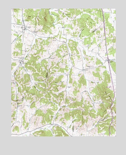
Campbells Station, TN USGS Topographic Map
Click on map above to begin viewing in our Map Viewer.

This topographic map contains these locations and features:
Feature Name Type Latitude Longitude GNIS ID View Map
Amis CemeteryCemeteryN35.4651°W86.9978°1646116View Map
Amis CemeteryCemeteryN35.4776°W86.9883°1304819View Map
Ashton CemeteryCemeteryN35.4909°W86.9183°1646119View Map
Askey FieldAirportN35.4578°W86.9573°2675505View Map
Ayres HollowValleyN35.4077°W86.8992°1276031View Map
Ballanfant CemeteryCemeteryN35.4815°W86.9936°1304942View Map
Baty CemeteryCemeteryN35.4873°W86.9311°1646126View Map
Bear CreekStreamN35.4687°W86.9325°1276577View Map
Bear Creek ChurchChurchN35.4231°W86.9319°1276604View Map
Bethany CemeteryCemeteryN35.4987°W86.9439°1646131View Map
Bethany ChurchChurchN35.4979°W86.9422°1277082View Map
BivensPopulated PlaceN35.3870°W86.9522°1277532View Map
Braden HollowValleyN35.4265°W86.9742°1278153View Map
Brown CemeteryCemeteryN35.4745°W86.9269°1646145View Map
Bryant CemeteryCemeteryN35.4420°W86.9019°1278737View Map
Byrd HollowValleyN35.4913°W86.9176°1279256View Map
Calvert BranchStreamN35.3851°W86.9497°1305615View Map
Campbell Station School (historical)SchoolN35.4445°W86.9875°1323672View Map
Campbells StationPopulated PlaceN35.4467°W86.9889°1305645View Map
Campbells Station BranchStreamN35.4459°W86.9881°1305646View Map
Cave SpringSpringN35.4940°W86.9328°1279949View Map
Cheatham SpringSpringN35.4517°W86.9539°1280309View Map
Clark HollowValleyN35.4288°W86.9737°1280607View Map
Coffeys Mill (historical)LocaleN35.4579°W86.9303°1323678View Map
Cohea CemeteryCemeteryN35.4681°W86.9886°1646171View Map
Colvett CemeteryCemeteryN35.4040°W86.9019°1281029View Map
Colvett HollowValleyN35.3799°W86.9077°1281030View Map
Cox CemeteryCemeteryN35.3840°W86.9317°1281482View Map
CulleokaPopulated PlaceN35.4795°W86.9831°1306220View Map
Culleoka Fire DepartmentBuildingN35.4759°W86.9903°2653874View Map
Culleoka Post OfficePost OfficeN35.4798°W86.9834°1652213View Map
Culleoka SchoolSchoolN35.4820°W86.9869°1323684View Map
Dabney CemeteryCemeteryN35.3878°W86.9403°1281956View Map
Devils BackboneRidgeN35.4134°W86.8836°1282382View Map
District 6 (historical)CivilN35.4667°W86.9833°1310215View Map
Dodson CemeteryCemeteryN35.3926°W86.9939°1306361View Map
Dodson GapGapN35.4095°W86.9931°1306364View Map
Dodson SidingLocaleN35.4056°W86.9925°1306365View Map
East Fork Globe CreekStreamN35.4492°W86.8931°1283343View Map
Elk Ridge CemeteryCemeteryN35.3834°W86.9661°1283640View Map
Elk Ridge Presbyterian Church (historical)ChurchN35.3834°W86.9653°1643989View Map
Elk Valley Church (historical)ChurchN35.3773°W86.9306°1316268View Map
Evergreen CemeteryCemeteryN35.4273°W86.9961°1283925View Map
Evergreen Cumberland Presbyterian Church (historical)ChurchN35.4279°W86.9961°1646209View Map
Fitzpatrick CemeteryCemeteryN35.4684°W86.9453°1284339View Map
Fitzspatrick CemeteryCemeteryN35.4953°W86.9750°1646216View Map
Fountain Creek CemeteryCemeteryN35.4851°W86.9969°1646223View Map
Fountain Creek ChurchChurchN35.4501°W86.9881°1284710View Map
Fowler HollowValleyN35.3800°W86.9343°1284748View Map
Fox BranchStreamN35.4556°W86.9292°1284758View Map
Friendship CemeteryCemeteryN35.4778°W86.9739°1646227View Map
Friendship ChurchChurchN35.4770°W86.9725°1306465View Map
Garrett CemeteryCemeteryN35.4720°W86.9114°1285188View Map
Garron CemeteryCemeteryN35.4612°W86.9197°1646062View Map
Gill CemeteryCemeteryN35.4517°W86.9964°1285391View Map
Gimlet BranchStreamN35.4001°W86.9436°1285437View Map
Globe CreekStreamN35.4842°W86.9447°1285529View Map
Gupton BranchStreamN35.4501°W86.8942°1286450View Map
Happy HollowValleyN35.4301°W86.9338°1286760View Map
Haynes CemeteryCemeteryN35.4967°W86.9075°1287225View Map
Holt CemeteryCemeteryN35.4667°W86.9356°1288157View Map
Interchange 32CrossingN35.4495°W86.8839°1310506View Map
James HollowValleyN35.3834°W86.9539°1289279View Map
Johnson BranchStreamN35.4740°W86.9881°1306628View Map
Lambert HollowValleyN35.4307°W86.9090°1290554View Map
Lowery ChapelChurchN35.4254°W86.9542°1292232View Map
Mackenzie SchoolSchoolN35.4479°W86.8825°1292448View Map
Marsh LakeReservoirN35.3783°W86.8816°1301785View Map
Marsh Lake DamDamN35.3784°W86.8817°1301784View Map
Martin HollowValleyN35.4456°W86.9869°1292841View Map
McConnell BranchStreamN35.4623°W86.9144°1293180View Map
McKibbon HollowValleyN35.4693°W86.9212°1293364View Map
McKnight BranchStreamN35.4537°W86.9067°1293389View Map
McKnight CemeteryCemeteryN35.4717°W86.8925°1293392View Map
Moore CemeteryCemeteryN35.4903°W86.9950°1646465View Map
MooresvillePopulated PlaceN35.4401°W86.9142°1294323View Map
Mooresville CreekStreamN35.4606°W86.9131°1294324View Map
Mooresville Fire DepartmentBuildingN35.4352°W86.9229°2653726View Map
Mooresville SchoolSchoolN35.4423°W86.9061°1294325View Map
Mount AnnieSummitN35.4962°W86.9811°1646118View Map
Mount IdaSummitN35.4912°W86.9792°1288899View Map
New Bear Creek CemeteryCemeteryN35.4237°W86.9331°1644557View Map
Old Bear Creek CemeteryCemeteryN35.4228°W86.9356°1644558View Map
Old Mars Hill CemeteryCemeteryN35.3770°W86.8903°1644559View Map
Pea RidgeRidgeN35.4870°W86.9672°1297029View Map
Pickens CemeteryCemeteryN35.4098°W86.9000°1297391View Map
Pickens HollowValleyN35.4213°W86.9086°1297393View Map
Piuge Brothers LakeReservoirN35.4284°W86.9217°1301827View Map
Piuge Brothers Lake DamDamN35.4284°W86.9217°1301828View Map
Pleasant GrovePopulated PlaceN35.4867°W86.9856°1306902View Map
Rall HollowValleyN35.4180°W86.9432°1639539View Map
Ramsey CemeteryCemeteryN35.4367°W86.9744°1646510View Map
Redding CemeteryCemeteryN35.4634°W86.9864°1646512View Map
Renfro CemeteryCemeteryN35.4774°W86.9546°1646514View Map
Rise-Warden CemeteryCemeteryN35.4390°W86.9844°1646517View Map
Robertson Fork CemeteryCemeteryN35.3756°W86.9172°1299670View Map
Rockdale School (historical)SchoolN35.4704°W86.9533°1324886View Map
Round HillLocaleN35.3940°W86.9500°1300154View Map
Round Hill African Methodist Episcopal ChurchChurchN35.3936°W86.9513°2611458View Map
Round Hill CemeteryCemeteryN35.3928°W86.9492°1644035View Map
Round Hill Missionary Baptist ChurchChurchN35.3940°W86.9500°1316098View Map
Round Hill School (historical)SchoolN35.3934°W86.9503°1316311View Map
Shane CemeteryCemeteryN35.4540°W86.9869°1301212View Map
Shanes Church (historical)ChurchN35.4540°W86.9875°1646534View Map
Shaw CemeteryCemeteryN35.4748°W86.9633°1269933View Map
Sheepneck CreekStreamN35.4654°W86.9336°1269970View Map
Smith SpringSpringN35.4806°W86.9361°1270707View Map
Smyrna ChurchChurchN35.4979°W86.8925°1270742View Map
South Fork Fountain CreekStreamN35.4706°W86.9692°1270866View Map
Toombs HillSummitN35.4237°W86.9642°1272772View Map
Trade BranchStreamN35.3756°W86.9800°1272827View Map
Trigg BranchStreamN35.3770°W86.9833°1272876View Map
Union Valley School (historical)SchoolN35.4037°W86.9408°1316321View Map
Vincent CemeteryCemeteryN35.4737°W86.8925°1304306View Map
Wells CemeteryCemeteryN35.4601°W86.9795°1274103View Map
Wilkes CemeteryCemeteryN35.4190°W86.9100°1274590View Map
Wilkes HollowValleyN35.3798°W86.9222°1274591View Map

Note: Coordinates in the location and feature list above are referenced to NAD83 datum.


Copyright (C) 2008-2025 Ryan Niemi / Sunset Dynamics ... All Rights Reserved