TopoQuest Logo
Do you find TopoQuest useful?
Help keep TopoQuest running and adding new maps/features by donating!
Bitcoin:  19c7KJd3qBynnjoSw5npx9KScwjBe4ifkT
Litecoin:  LXs6TkuXGGXo1vDsWCkWVdjQX94eUKd6ui
Home View Maps Find Maps Find Places Resources & Links


Verona, Tennessee Topographic Map

USGS Map Title: Verona, TN
USGS Map MRC: 35086E7
DRG (GeoTIFF) Download: o35086e7.tif


Neighboring USGS Topographic Map Quads:


  Carters Creek, TN  
35086F8
 

  Rally Hill, TN  
35086F7
 

  Chapel Hill, TN  
35086F6
 

  Glendale, TN  
35086E8
 

  Verona, TN  
35086E7
 

  Farmington, TN  
35086E6
 

  Campbells Station, TN  
35086D8
 

  Lewisburg, TN  
35086D7
 

  Belfast, TN  
35086D6


Map MRC Location:

N36°
W87°
N36°
W86°
H8 H7 H6 H5 H4 H3 H2 H1
G8 G7 G6 G5 G4 G3 G2 G1
F8 F7 F6 F5 F4 F3 F2 F1
E8 E7 E6 E5 E4 E3 E2 E1
D8 D7 D6 D5 D4 D3 D2 D1
C8 C7 C6 C5 C4 C3 C2 C1
B8 B7 B6 B5 B4 B3 B2 B1
A8 A7 A6 A5 A4 A3 A2 A1
N35°
W87°
N35°
W86°

Verona, TN USGS 1:24K Topographic Map Preview:
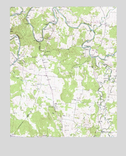
Verona, TN USGS Topographic Map
Click on map above to begin viewing in our Map Viewer.

This topographic map contains these locations and features:
Feature Name Type Latitude Longitude GNIS ID View Map
Allen CemeteryCemeteryN35.5992°W86.7672°1275582View Map
AnesPopulated PlaceN35.5587°W86.7508°1275758View Map
Antioch ChurchChurchN35.5709°W86.8642°1304849View Map
Baptizing IslandIslandN35.6187°W86.8236°1313211View Map
Berea CemeteryCemeteryN35.5390°W86.7694°1644545View Map
Berea ChurchChurchN35.5387°W86.7689°1277034View Map
BerlinPopulated PlaceN35.5298°W86.8244°1277039View Map
Berlin Fire DepartmentBuildingN35.5302°W86.8280°2653876View Map
Berlin HillSummitN35.5228°W86.8217°1277040View Map
Berlin School (historical)SchoolN35.5270°W86.8239°1320166View Map
Berlin SpringSpringN35.5290°W86.8247°1277043View Map
Berlin United Methodist ChurchChurchN35.5301°W86.8269°1316523View Map
Bethlehem CemeteryCemeteryN35.5715°W86.8361°1277155View Map
Bethlehem ChurchChurchN35.5787°W86.8347°1305165View Map
Betsy BluffCliffN35.5173°W86.7603°1277182View Map
Big Rock CreekStreamN35.5762°W86.7753°1305230View Map
Big Spring IslandIslandN35.6217°W86.8194°1277419View Map
Boyett CemeteryCemeteryN35.5062°W86.8108°1278129View Map
Brown CemeteryCemeteryN35.6248°W86.8411°1278532View Map
Bull BluffCliffN35.5967°W86.8658°1278937View Map
Caney CreekStreamN35.6023°W86.7778°1305670View Map
Caney SpringSpringN35.6078°W86.7636°1279596View Map
Caney SpringPopulated PlaceN35.6073°W86.7631°1310503View Map
Caney Springs School (historical)SchoolN35.6059°W86.7589°1320167View Map
Caney Springs United Methodist ChurchChurchN35.6065°W86.7597°1644547View Map
Carpenters BridgeBridgeN35.6178°W86.8664°1305691View Map
Cheek BendBendN35.6145°W86.8556°1280311View Map
Cheek BridgeBridgeN35.5698°W86.7653°1280312View Map
Childress CemeteryCemeteryN35.5228°W86.8714°1280454View Map
Clymore CemeteryCemeteryN35.5998°W86.8328°1646169View Map
Clymore CemeteryCemeteryN35.6051°W86.8253°1280791View Map
Cole BendBendN35.5992°W86.8425°1280917View Map
Commissioner District 5CivilN35.5153°W86.8297°2464474View Map
Commissioner District 6CivilN35.5770°W86.7904°2464558View Map
Commissioner District 7CivilN35.5129°W86.7710°2464631View Map
CowdenPopulated PlaceN35.5148°W86.7717°1314899View Map
Cundiff Ford IslandIslandN35.6090°W86.8533°1281858View Map
Cundiff IslandIslandN35.6103°W86.8100°1281859View Map
Cunningham CemeteryCemeteryN35.5356°W86.7978°1281868View Map
District 3 (historical)CivilN35.5834°W86.8667°1310212View Map
Double BridgesBridgeN35.5045°W86.7675°1282688View Map
Dry CreekStreamN35.5540°W86.8603°1282913View Map
East Rock CreekStreamN35.5648°W86.7606°1303448View Map
Ellington AirportAirportN35.5004°W86.8083°1301344View Map
Hardison CemeteryCemeteryN35.5651°W86.8481°1286846View Map
Hardison MillPopulated PlaceN35.6103°W86.8231°1315190View Map
Higgs ChapelChurchN35.5595°W86.7514°1287693View Map
Jackson BendBendN35.5948°W86.8681°1289180View Map
Jackson CemeteryCemeteryN35.5573°W86.8581°1289195View Map
Jackson CemeteryCemeteryN35.5934°W86.8689°1289196View Map
Jones BendBendN35.6045°W86.8614°1289687View Map
Lebanon CemeteryCemeteryN35.5670°W86.7975°1290903View Map
LeftwichPopulated PlaceN35.5731°W86.8667°1315375View Map
Lewisburg Pumping StationBuildingN35.5745°W86.7658°1291095View Map
Liggett CemeteryCemeteryN35.5103°W86.8108°1291263View Map
Liggett CemeteryCemeteryN35.5681°W86.8342°1646063View Map
Lillard CemeteryCemeteryN35.5806°W86.7900°1291278View Map
Lillard MillPopulated PlaceN35.5867°W86.7847°1315400View Map
Lillard Mill Power Plant (historical)BuildingN35.5870°W86.7844°1316553View Map
Littlejohn HillSummitN35.5703°W86.8586°1291719View Map
Marsh Ford IslandIslandN35.6076°W86.8314°1292752View Map
Marshall BridgeBridgeN35.5765°W86.7789°1292756View Map
McCurdy CemeteryCemeteryN35.5331°W86.7714°1293048View Map
McLean BendBendN35.5998°W86.7883°1293399View Map
MilltownPopulated PlaceN35.5840°W86.7867°1315516View Map
Milltown Church (historical)ChurchN35.5798°W86.7903°1316559View Map
Milltown DamDamN35.5866°W86.7844°2436789View Map
Morton CemeteryCemeteryN35.5498°W86.8458°1294466View Map
Mouth of Creek IslandIslandN35.6023°W86.7789°1294964View Map
New Hebron ChurchChurchN35.5828°W86.8319°1295493View Map
Old Trap IslandIslandN35.5956°W86.8367°1296385View Map
OslinPopulated PlaceN35.5284°W86.7642°1315659View Map
Osteen BendBendN35.6176°W86.8194°1296505View Map
Ownby CemeteryCemeteryN35.5201°W86.8111°1296614View Map
Ownby CemeteryCemeteryN35.5320°W86.8228°1296615View Map
Paradise Airpark (historical)AirportN35.5188°W86.8532°2717065View Map
Pumpkin CreekStreamN35.5781°W86.8656°1306929View Map
Rice BranchStreamN35.5751°W86.7786°1299293View Map
Rone CemeteryCemeteryN35.6156°W86.7778°1300042View Map
Sanctified HillSummitN35.5678°W86.7769°1300653View Map
Silver CreekPopulated PlaceN35.5020°W86.8747°1314293View Map
Slick Shoals IslandIslandN35.5920°W86.7853°1270513View Map
South BerlinPopulated PlaceN35.5006°W86.8367°1270834View Map
Sycamore Patch IslandIslandN35.6040°W86.8364°1272006View Map
Tankersley CemeteryCemeteryN35.5526°W86.7675°1272082View Map
Tates IslandIslandN35.6217°W86.8519°1272168View Map
The Sheep NeckCapeN35.5563°W86.7591°1272438View Map
Tindell CemeteryCemeteryN35.5953°W86.8292°1272665View Map
Venable SpringPopulated PlaceN35.6076°W86.7822°1273419View Map
VeronaPopulated PlaceN35.5306°W86.7697°1273433View Map
Verona School (historical)SchoolN35.5301°W86.7722°1320170View Map
Verona United Methodist ChurchChurchN35.5295°W86.7722°1644565View Map
Whitehead SpringSpringN35.5770°W86.8494°1274418View Map
Whitsell CemeteryCemeteryN35.5117°W86.7886°1274487View Map
Willet BranchStreamN35.5915°W86.8400°1313529View Map
Willie BluffCliffN35.5920°W86.8428°1274731View Map
Worm IslandIslandN35.5784°W86.7611°1275133View Map
Wright BranchStreamN35.5376°W86.7694°1275156View Map
Wright IslandIslandN35.5790°W86.8656°1275183View Map

Note: Coordinates in the location and feature list above are referenced to NAD83 datum.


Copyright (C) 2008-2025 Ryan Niemi / Sunset Dynamics ... All Rights Reserved