TopoQuest Logo
Do you find TopoQuest useful?
Help keep TopoQuest running and adding new maps/features by donating!
Bitcoin:  19c7KJd3qBynnjoSw5npx9KScwjBe4ifkT
Litecoin:  LXs6TkuXGGXo1vDsWCkWVdjQX94eUKd6ui
Home View Maps Find Maps Find Places Resources & Links


Atkins, Virginia Topographic Map

USGS Map Title: Atkins, VA
USGS Map MRC: 36081G4
DRG (GeoTIFF) Download: o36081g4.tif


Neighboring USGS Topographic Map Quads:


  Chatham Hill, VA  
36081H5
 

  Nebo, VA  
36081H4
 

  Rural Retreat, VA  
36081H3
 

  Marion, VA  
36081G5
 

  Atkins, VA  
36081G4
 

  Cedar Springs, VA  
36081G3
 

  Whitetop Mountain, VA  
36081F5
 

  Trout Dale, VA  
36081F4
 

  Middle Fox Creek, VA  
36081F3


Map MRC Location:

N37°
W82°
N37°
W81°
H8 H7 H6 H5 H4 H3 H2 H1
G8 G7 G6 G5 G4 G3 G2 G1
F8 F7 F6 F5 F4 F3 F2 F1
E8 E7 E6 E5 E4 E3 E2 E1
D8 D7 D6 D5 D4 D3 D2 D1
C8 C7 C6 C5 C4 C3 C2 C1
B8 B7 B6 B5 B4 B3 B2 B1
A8 A7 A6 A5 A4 A3 A2 A1
N36°
W82°
N36°
W81°

Atkins, VA USGS 1:24K Topographic Map Preview:
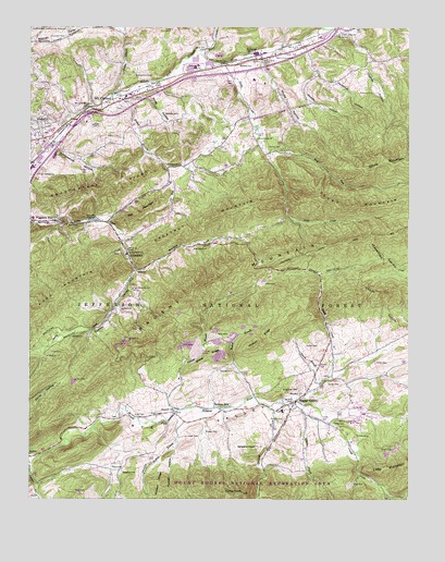
Atkins, VA USGS Topographic Map
Click on map above to begin viewing in our Map Viewer.

This topographic map contains these locations and features:
Feature Name Type Latitude Longitude GNIS ID View Map
Anderson CemeteryCemeteryN36.8726°W81.4932°1481310View Map
Arney HollowValleyN36.8567°W81.4654°1481341View Map
AtkinsPopulated PlaceN36.8673°W81.4234°1481353View Map
Atkins CemeteryCemeteryN36.8726°W81.3945°1481354View Map
Atkins Census Designated PlaceCensusN36.8674°W81.3992°2389156View Map
Atkins Elementary SchoolSchoolN36.8680°W81.4191°1500441View Map
Atkins Post OfficePost OfficeN36.8669°W81.4205°2780801View Map
Atkins Volunteer Fire DepartmentBuildingN36.8664°W81.4252°2085930View Map
AttowayPopulated PlaceN36.8135°W81.4673°1481357View Map
Bear CreekStreamN36.8687°W81.4432°1481513View Map
Bishop BranchStreamN36.7776°W81.4259°1481813View Map
Cardinal QuarriesMineN36.8678°W81.4389°2724871View Map
Carrico CemeteryCemeteryN36.8429°W81.4162°1482334View Map
Cedar Bluff ChurchChurchN36.8737°W81.3971°1482391View Map
Centenary ChurchChurchN36.8387°W81.4548°1482420View Map
Centenary School (historical)SchoolN36.8387°W81.4554°1500450View Map
Chestnut MountainSummitN36.8285°W81.4254°1492758View Map
Comers CreekStreamN36.7596°W81.4993°1482669View Map
Cress CemeteryCemeteryN36.7707°W81.3987°1482829View Map
Cressy CreekStreamN36.7740°W81.4107°1482830View Map
Currin School (historical)SchoolN36.7948°W81.4790°1500459View Map
Currin ValleyValleyN36.8106°W81.4647°1482882View Map
Davis Memorial ChurchChurchN36.8673°W81.4182°1482948View Map
Dickey CreekStreamN36.7743°W81.4204°1483003View Map
Dickey KnobSummitN36.7521°W81.4296°1483005View Map
Dry RunStreamN36.8376°W81.4543°1483129View Map
East Fork Nicks CreekStreamN36.8418°W81.4207°1483211View Map
Elizabeth ChurchChurchN36.7735°W81.4523°1483263View Map
Falling Water ChurchChurchN36.8148°W81.4676°1483359View Map
First Church of GodChurchN36.8696°W81.4101°1500466View Map
Furnace HillPopulated PlaceN36.8237°W81.4907°1492984View Map
Furnace Hill Lutheran ChurchChurchN36.8240°W81.4918°1500470View Map
Georges BranchStreamN36.7729°W81.4512°1483604View Map
Goodpasture CemeteryCemeteryN36.8623°W81.4651°1483697View Map
Goodpasture HollowValleyN36.8431°W81.4909°1483698View Map
Goodpasture RidgeRidgeN36.8332°W81.4746°1483699View Map
Hazelnut HollowValleyN36.8623°W81.4049°1484002View Map
Hickory RidgeRidgeN36.7904°W81.4259°1484070View Map
Houndshell BranchStreamN36.7521°W81.3818°1484241View Map
Hutton BranchStreamN36.8582°W81.4701°1484304View Map
Hutton CemeteryCemeteryN36.7712°W81.4159°1484305View Map
Hutton CemeteryCemeteryN36.8462°W81.4701°1484306View Map
Interchange 47CrossingN36.8501°W81.4837°1500482View Map
Interchange 50CrossingN36.8632°W81.4343°1500483View Map
Keesling CemeteryCemeteryN36.7576°W81.4690°1484528View Map
Long HollowValleyN36.8193°W81.4296°1500492View Map
Marchant CemeteryCemeteryN36.8159°W81.4457°1485182View Map
Marchant CreekStreamN36.8104°W81.4648°1485183View Map
Marion Plaza Shopping CenterLocaleN36.8454°W81.4971°1500502View Map
Marion Primary SchoolSchoolN36.8452°W81.4975°1500504View Map
Marion State Fish HatcheryLocaleN36.8237°W81.4787°1488569View Map
McGhee CemeteryCemeteryN36.8521°W81.4504°1485298View Map
Mill MountainSummitN36.8254°W81.4634°1493290View Map
Morgan CemeteryCemeteryN36.7671°W81.4373°1485551View Map
Mount CarmelPopulated PlaceN36.8534°W81.4782°1485573View Map
Mount Carmel United Methodist ChurchChurchN36.8548°W81.4737°1500512View Map
Mount Rogers National Recreation Area OfficeLocaleN36.8115°W81.4204°1488570View Map
Mount Rogers Work CenterLocaleN36.7679°W81.3948°1488571View Map
Mullins BranchStreamN36.7723°W81.4523°1485754View Map
Nelson CemeteryCemeteryN36.7707°W81.3979°1485822View Map
Nick Creek School (historical)SchoolN36.8454°W81.4248°1500518View Map
Nicks CreekStreamN36.8654°W81.4343°1485874View Map
Nicks Creek ChurchChurchN36.8454°W81.4246°1485875View Map
Overbay CemeteryCemeteryN36.8573°W81.3868°1486018View Map
Overbay HollowValleyN36.8735°W81.3938°1486019View Map
Pierce BranchStreamN36.7807°W81.4034°1486189View Map
Pierce CemeteryCemeteryN36.7904°W81.4084°1486190View Map
Porter CemeteryCemeteryN36.7859°W81.3857°1486362View Map
Pugh CemeteryCemeteryN36.7726°W81.4598°1486444View Map
Pugh Mountain ChurchChurchN36.8054°W81.4659°1486445View Map
Quarter BranchStreamN36.7760°W81.4159°1486465View Map
Ridgelawn CemeteryCemeteryN36.7790°W81.4104°1486605View Map
Roberts MillPopulated PlaceN36.7743°W81.4387°1493498View Map
Rose Lawn CemeteryCemeteryN36.8537°W81.4723°1500531View Map
Ross CemeteryCemeteryN36.7537°W81.3932°1486781View Map
Russell HollowValleyN36.7708°W81.4488°1486827View Map
Russell RidgeRidgeN36.7560°W81.4573°1486830View Map
Rye ValleyValleyN36.7676°W81.4689°1486839View Map
Rye Valley DistrictCivilN36.7526°W81.4683°1927482View Map
Saint Mathews ChurchChurchN36.8737°W81.3976°1956872View Map
Scott CemeteryCemeteryN36.7662°W81.4476°1486973View Map
Scott CemeteryCemeteryN36.7721°W81.4637°1486974View Map
Shady GrovePopulated PlaceN36.7826°W81.3998°1956868View Map
Sheep RidgeRidgeN36.7876°W81.4409°1487169View Map
Shupe HollowValleyN36.8664°W81.4234°1487237View Map
SlabtownPopulated PlaceN36.7579°W81.4704°1493606View Map
Slabtown BranchStreamN36.7690°W81.4787°1500542View Map
Slabtown HollowValleyN36.7534°W81.4974°1500543View Map
Slemp CemeteryCemeteryN36.7807°W81.3976°1487309View Map
Slemp CreekStreamN36.7821°W81.4012°1487312View Map
Smyth County Ambulance ServiceBuildingN36.8241°W81.4965°2721094View Map
Smyth County Community HospitalHospitalN36.8521°W81.4882°1500546View Map
Snider BranchStreamN36.8573°W81.4721°1487370View Map
Sugar GrovePopulated PlaceN36.7757°W81.4123°1487691View Map
Sugar Grove Census Designated PlaceCensusN36.7688°W81.4075°2390371View Map
Sugar Grove Combined SchoolSchoolN36.7733°W81.4163°1500552View Map
Sugar Grove Life Saving CrewBuildingN36.7738°W81.4111°2085934View Map
Sugar Grove Post OfficePost OfficeN36.7754°W81.4131°2780821View Map
Sugar Grove Volunteer Fire DepartmentBuildingN36.7736°W81.4109°2085929View Map
TeasLocaleN36.7729°W81.4515°1487805View Map
Waddle HollowValleyN36.8620°W81.4054°1488143View Map
Wassum CemeteryCemeteryN36.8648°W81.4307°1488202View Map
Wharfhill ChurchChurchN36.7782°W81.4096°1488266View Map
Wildcat BranchStreamN36.7743°W81.4357°1500559View Map
William Andrew Scott Memorial BridgeBridgeN36.8532°W81.4779°1500560View Map
WOLD-AM (Marion)TowerN36.8198°W81.4698°1498946View Map
WOLD-FM (Marion)TowerN36.8165°W81.4609°1498998View Map

Note: Coordinates in the location and feature list above are referenced to NAD83 datum.


Copyright (C) 2008-2025 Ryan Niemi / Sunset Dynamics ... All Rights Reserved