TopoQuest Logo
Do you find TopoQuest useful?
Help keep TopoQuest running and adding new maps/features by donating!
Bitcoin:  19c7KJd3qBynnjoSw5npx9KScwjBe4ifkT
Litecoin:  LXs6TkuXGGXo1vDsWCkWVdjQX94eUKd6ui
Home View Maps Find Maps Find Places Resources & Links


Chatham Hill, Virginia Topographic Map

USGS Map Title: Chatham Hill, VA
USGS Map MRC: 36081H5
DRG (GeoTIFF) Download: o36081h5.tif


Neighboring USGS Topographic Map Quads:


  Pounding Mill, VA  
37081A6
 

  Tazewell South, VA  
37081A5
 

  Hutchinson Rock, VA  
37081A4
 

  Broadford, VA  
36081H6
 

  Chatham Hill, VA  
36081H5
 

  Nebo, VA  
36081H4
 

  Chilhowie, VA  
36081G6
 

  Marion, VA  
36081G5
 

  Atkins, VA  
36081G4


Map MRC Location:

N37°
W82°
N37°
W81°
H8 H7 H6 H5 H4 H3 H2 H1
G8 G7 G6 G5 G4 G3 G2 G1
F8 F7 F6 F5 F4 F3 F2 F1
E8 E7 E6 E5 E4 E3 E2 E1
D8 D7 D6 D5 D4 D3 D2 D1
C8 C7 C6 C5 C4 C3 C2 C1
B8 B7 B6 B5 B4 B3 B2 B1
A8 A7 A6 A5 A4 A3 A2 A1
N36°
W82°
N36°
W81°

Chatham Hill, VA USGS 1:24K Topographic Map Preview:
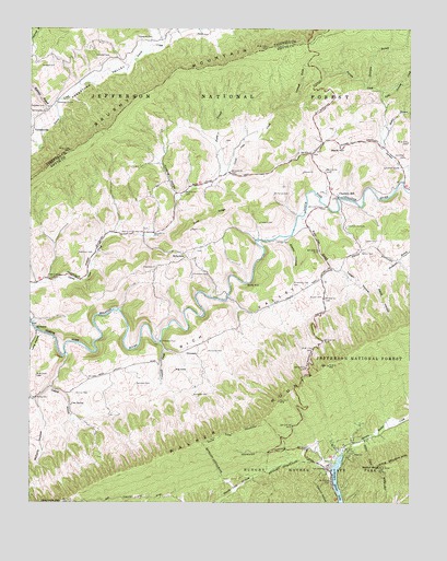
Chatham Hill, VA USGS Topographic Map
Click on map above to begin viewing in our Map Viewer.

This topographic map contains these locations and features:
Feature Name Type Latitude Longitude GNIS ID View Map
Baker BranchStreamN36.9693°W81.5087°1481403View Map
Beartown BranchStreamN36.9854°W81.5146°1481551View Map
Bently HoleBasinN36.9332°W81.5521°1481640View Map
Black HillSummitN36.9676°W81.5268°1492579View Map
Buchanan CemeteryCemeteryN36.9407°W81.6037°1482101View Map
Buchanan CemeteryCemeteryN36.9562°W81.5446°1482102View Map
Buchanan CemeteryCemeteryN36.9032°W81.5709°1482096View Map
Buchanan CemeteryCemeteryN36.9148°W81.5659°1482098View Map
Burnop CemeteryCemeteryN36.9034°W81.6096°1482177View Map
Caldwell CemeteryCemeteryN36.9923°W81.5990°1482217View Map
Campbell CemeteryCemeteryN36.9062°W81.5896°1482285View Map
Campbell CreekStreamN36.9173°W81.5818°1482287View Map
Cave SpringSpringN36.9008°W81.6113°1482386View Map
Chatham HillPopulated PlaceN36.9557°W81.5232°1482458View Map
Chatham Hill CemeteryCemeteryN36.9476°W81.5207°1482459View Map
Cove RidgeRidgeN36.9512°W81.5643°1482743View Map
Crabtree CemeteryCemeteryN36.9790°W81.6207°1482789View Map
Crabtree ChapelChurchN36.9807°W81.6159°1482792View Map
Crewey BranchStreamN36.9143°W81.6132°1482832View Map
Cursing HollowValleyN36.9562°W81.5770°1482885View Map
Davis HollowValleyN36.9351°W81.5092°1482946View Map
EllendalePopulated PlaceN36.9165°W81.5698°1492912View Map
Ellendale FordCrossingN36.9179°W81.5812°1492913View Map
Gillespie CemeteryCemeteryN36.9487°W81.5496°1483630View Map
Goodman CemeteryCemeteryN36.9662°W81.5015°1483695View Map
Goodman ChapelChurchN36.9634°W81.5029°1483696View Map
Hubble CemeteryCemeteryN36.9293°W81.5284°1484257View Map
Hungry Mother State ParkParkN36.8807°W81.5273°1484281View Map
Little Beartown BranchStreamN36.9779°W81.5021°1484870View Map
Little Sprouts CreekStreamN36.9829°W81.5090°1484978View Map
Locust CoveBayN36.9809°W81.5387°1485015View Map
Long HollowValleyN36.9200°W81.6220°1485057View Map
Longhollow (historical)Populated PlaceN36.9057°W81.6176°1500493View Map
Martin CemeteryCemeteryN36.9984°W81.5701°1485204View Map
Matneys BranchStreamN36.9796°W81.6162°1485224View Map
McCarty HollowValleyN36.8932°W81.6201°1485256View Map
Mitchell CemeteryCemeteryN36.9904°W81.6171°1485500View Map
Mollys KnobSummitN36.8843°W81.5098°1485514View Map
Nebo Volunteer Fire Department Station 1BuildingN36.9709°W81.5250°2085931View Map
Necessary CemeteryCemeteryN36.9976°W81.5848°1485812View Map
New Cove ChurchChurchN36.9459°W81.5943°1485840View Map
New Cove School (historical)SchoolN36.9459°W81.5951°1500517View Map
North Fork DistrictCivilN36.9179°W81.5678°1927425View Map
Old Cove School (historical)SchoolN36.9587°W81.5676°1500520View Map
Olinger CemeteryCemeteryN36.9437°W81.5434°1485971View Map
Orr CemeteryCemeteryN36.9076°W81.6051°1485994View Map
Park ChapelChurchN36.8840°W81.5273°1486062View Map
Park DistrictCivilN36.8758°W81.5174°1927436View Map
Pauly BranchStreamN36.9612°W81.5618°1486092View Map
Pleasant Grove School (historical)SchoolN36.9026°W81.6237°1500524View Map
Rich Valley ChurchChurchN36.9021°W81.6229°1486591View Map
Richardson CemeteryCemeteryN36.9326°W81.5334°1486596View Map
RidgedalePopulated PlaceN36.9407°W81.5737°1493485View Map
Ridgedale ChurchChurchN36.9365°W81.5829°1486604View Map
Rocko HollowValleyN36.9445°W81.5409°1486721View Map
Saltville Rescue Squad SubstationBuildingN36.9709°W81.5249°2721168View Map
Sexton CemeteryCemeteryN36.9407°W81.5154°1487012View Map
Sprouts CreekStreamN36.9598°W81.5023°1487480View Map
Sprouts Creek School (historical)SchoolN36.9704°W81.5093°1500550View Map
Tannersville ChurchChurchN36.9782°W81.6196°1487772View Map
Tannersville Post OfficePost OfficeN36.9729°W81.6246°2766306View Map
Thompson CemeteryCemeteryN36.9351°W81.5712°1487875View Map
Totten CemeteryCemeteryN36.9437°W81.5146°1487959View Map
Totten HollowValleyN36.9360°W81.5223°1487960View Map
White Oak BranchStreamN36.9482°W81.5368°1488289View Map
WMEV-FM (Marion)TowerN36.9023°W81.5423°1502669View Map
WMSY-TV (Marion)TowerN36.9004°W81.5429°1502751View Map
WOLD-FM (Marion)TowerN36.9029°W81.5407°1502670View Map

Note: Coordinates in the location and feature list above are referenced to NAD83 datum.


Copyright (C) 2008-2025 Ryan Niemi / Sunset Dynamics ... All Rights Reserved