TopoQuest Logo
Do you find TopoQuest useful?
Help keep TopoQuest running and adding new maps/features by donating!
Bitcoin:  19c7KJd3qBynnjoSw5npx9KScwjBe4ifkT
Litecoin:  LXs6TkuXGGXo1vDsWCkWVdjQX94eUKd6ui
Home View Maps Find Maps Find Places Resources & Links


Goodview, Virginia Topographic Map

USGS Map Title: Goodview, VA
USGS Map MRC: 37079B6
DRG (GeoTIFF) Download: o37079b6.tif


Neighboring USGS Topographic Map Quads:


  Stewartsville, VA  
37079C7
 

  Irving, VA  
37079C6
 

  Bedford, VA  
37079C5
 

  Hardy, VA  
37079B7
 

  Goodview, VA  
37079B6
 

  Moneta, VA  
37079B5
 

  Redwood, VA  
37079A7
 

  Moneta SW, VA  
37079A6
 

  Smith Mountain Dam, VA  
37079A5


Map MRC Location:

N38°
W80°
N38°
W79°
H8 H7 H6 H5 H4 H3 H2 H1
G8 G7 G6 G5 G4 G3 G2 G1
F8 F7 F6 F5 F4 F3 F2 F1
E8 E7 E6 E5 E4 E3 E2 E1
D8 D7 D6 D5 D4 D3 D2 D1
C8 C7 C6 C5 C4 C3 C2 C1
B8 B7 B6 B5 B4 B3 B2 B1
A8 A7 A6 A5 A4 A3 A2 A1
N37°
W80°
N37°
W79°

Goodview, VA USGS 1:24K Topographic Map Preview:
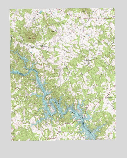
Goodview, VA USGS Topographic Map
Click on map above to begin viewing in our Map Viewer.

This topographic map contains these locations and features:
Feature Name Type Latitude Longitude GNIS ID View Map
Altice CemeteryCemeteryN37.1385°W79.7073°1791025View Map
Aylor CemeteryCemeteryN37.1526°W79.7495°1791031View Map
Basham CemeteryCemeteryN37.1812°W79.7417°1791032View Map
Beaverdam CreekStreamN37.1921°W79.7273°1481569View Map
Beechwood ShoresPopulated PlaceN37.1415°W79.6559°1674820View Map
Board MountainSummitN37.2215°W79.7242°1494844View Map
Booth-Joplin CemeteryCemeteryN37.1274°W79.6664°1791040View Map
Buff CreekStreamN37.1824°W79.7192°1464025View Map
Cape CarlynPopulated PlaceN37.1501°W79.7145°1494403View Map
Carters Island FordCrossingN37.1854°W79.7184°1674828View Map
Casey CemeteryCemeteryN37.1329°W79.6867°1791048View Map
Clevilas (historical)Populated PlaceN37.2090°W79.6831°1674831View Map
Diamond HillPopulated PlaceN37.1918°W79.6875°1477261View Map
Diamond Hill ChurchChurchN37.1926°W79.6878°1674837View Map
Ellis CemeteryCemeteryN37.1387°W79.7109°1791066View Map
Ellis CemeteryCemeteryN37.1624°W79.7170°1791067View Map
Ellis-Blankenship CemeteryCemeteryN37.1774°W79.7325°1791065View Map
Emmaus (historical)Populated PlaceN37.2368°W79.6581°1674841View Map
Emmaus ChurchChurchN37.2226°W79.6623°1466298View Map
Emmaus School (historical)SchoolN37.2179°W79.6648°1674842View Map
Epworth CemeteryCemeteryN37.1329°W79.6936°1791068View Map
Epworth ChurchChurchN37.1329°W79.6928°1466336View Map
Ferguson-Hatcher CemeteryCemeteryN37.1285°W79.6984°1791069View Map
GoodviewPopulated PlaceN37.2143°W79.7250°1477363View Map
Goodview ChurchChurchN37.2088°W79.7153°1467230View Map
Goodview Post OfficePost OfficeN37.2148°W79.7288°2766218View Map
Green Spring ChurchChurchN37.2149°W79.7100°1467486View Map
Grimes CreekStreamN37.1665°W79.7117°1467548View Map
Haleford (historical)Populated PlaceN37.1460°W79.6656°1674849View Map
Hales CreekStreamN37.1499°W79.6673°1467651View Map
Hales FordCrossingN37.1454°W79.6670°1674850View Map
Hales Ford (historical)Populated PlaceN37.1268°W79.6995°1494796View Map
Hales Ford BridgeBridgeN37.1454°W79.6661°1467652View Map
Hatfield CreekStreamN37.1557°W79.7092°1467829View Map
Hendricks StoreLocaleN37.1665°W79.6350°1467922View Map
Hetrick DamDamN37.1301°W79.7448°1489802View Map
Hetrick PondReservoirN37.1301°W79.7448°1489803View Map
Holdrens DamDamN37.2468°W79.7131°1489231View Map
Holdrens PondReservoirN37.2468°W79.7128°1489232View Map
Indian CreekStreamN37.1499°W79.7061°1468469View Map
Jenkins CemeteryCemeteryN37.1804°W79.7220°1791084View Map
Jumping RunStreamN37.1932°W79.7250°1468904View Map
Kasey MountainSummitN37.2279°W79.7014°1495010View Map
Kates CreekStreamN37.2246°W79.7478°1468914View Map
Maxey CemeteryCemeteryN37.1543°W79.7259°1791094View Map
Mead MountainSummitN37.2471°W79.6589°1470289View Map
MeadorPopulated PlaceN37.2004°W79.6564°1477530View Map
Meador CemeteryCemeteryN37.1290°W79.6689°1791098View Map
Meadows Mill (historical)LocaleN37.1982°W79.7200°1674864View Map
Meads StoreLocaleN37.2401°W79.6553°1470330View Map
Minter CemeteryCemeteryN37.1824°W79.6806°1674866View Map
Moneta Post OfficePost OfficeN37.1719°W79.6317°2766252View Map
Moneta Volunteer Fire Department Station 3BuildingN37.1953°W79.6854°2075571View Map
Olive Branch ChurchChurchN37.2485°W79.6259°1471902View Map
Perdue CemeteryCemeteryN37.1357°W79.7464°1791109View Map
Promised Land School (historical)SchoolN37.1538°W79.6267°1674889View Map
Robertson CemeteryCemeteryN37.1324°W79.7489°1473320View Map
Staunton River Middle SchoolSchoolN37.2411°W79.6261°2498623View Map
Stony CreekStreamN37.1582°W79.6917°1475205View Map
Teels Mill (historical)LocaleN37.1496°W79.7067°1494802View Map
Turners FordCrossingN37.1501°W79.7036°1494803View Map
WBLU-AM (Moneta)TowerN37.1668°W79.6303°1502513View Map
Western Light ChurchChurchN37.1638°W79.6400°1476517View Map
Westlake Golf and Country ClubLocaleN37.1334°W79.7192°2520206View Map
Wilson CemeteryCemeteryN37.1401°W79.7084°1791141View Map

Note: Coordinates in the location and feature list above are referenced to NAD83 datum.


Copyright (C) 2008-2024 Ryan Niemi / Sunset Dynamics ... All Rights Reserved