TopoQuest Logo
Do you find TopoQuest useful?
Help keep TopoQuest running and adding new maps/features by donating!
Bitcoin:  19c7KJd3qBynnjoSw5npx9KScwjBe4ifkT
Litecoin:  LXs6TkuXGGXo1vDsWCkWVdjQX94eUKd6ui
Home View Maps Find Maps Find Places Resources & Links


Goosepond Mountain, Arkansas Topographic Map

USGS Map Title: Goosepond Mountain, AR
USGS Map MRC: 34092F8
DRG (GeoTIFF) Download: o34092f8.tif


Neighboring USGS Topographic Map Quads:


  Nimrod SE, AR  
34093G1
 

  Paron SW, AR  
34092G8
 

  Paron, AR  
34092G7
 

  Jessieville, AR  
34093F1
 

  Goosepond Mountain, AR  
34092F8
 

  Lonsdale NE, AR  
34092F7
 

  Hot Springs North, AR  
34093E1
 

  Fountain Lake, AR  
34092E8
 

  Lonsdale, AR  
34092E7


Map MRC Location:

N35°
W93°
N35°
W92°
H8 H7 H6 H5 H4 H3 H2 H1
G8 G7 G6 G5 G4 G3 G2 G1
F8 F7 F6 F5 F4 F3 F2 F1
E8 E7 E6 E5 E4 E3 E2 E1
D8 D7 D6 D5 D4 D3 D2 D1
C8 C7 C6 C5 C4 C3 C2 C1
B8 B7 B6 B5 B4 B3 B2 B1
A8 A7 A6 A5 A4 A3 A2 A1
N34°
W93°
N34°
W92°

Goosepond Mountain, AR USGS 1:24K Topographic Map Preview:
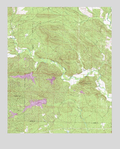
Goosepond Mountain, AR USGS Topographic Map
Click on map above to begin viewing in our Map Viewer.

This topographic map contains these locations and features:
Feature Name Type Latitude Longitude GNIS ID View Map
Angling CreekStreamN34.7195°W92.9935°70446View Map
Antioch ChurchChurchN34.6879°W92.9082°66875View Map
Balboa Golf CourseLocaleN34.6365°W92.9399°64288View Map
Beaudry (historical)Populated PlaceN34.7131°W92.9918°64287View Map
BlocherPopulated PlaceN34.6876°W92.9068°65978View Map
Brushy CreekStreamN34.7076°W92.9813°70862View Map
Coronado Golf CourseLocaleN34.6420°W92.9477°65979View Map
Cortez Golf CourseLocaleN34.6959°W92.9835°64299View Map
Electric (historical)Populated PlaceN34.7354°W92.9110°65980View Map
Goosepond MountainSummitN34.6754°W92.9102°66879View Map
Hot Springs VillagePopulated PlaceN34.6720°W92.9988°72091View Map
Hot Springs Village Census Designated PlaceCensusN34.6567°W92.9642°2402601View Map
Hot Springs Village Fire Department Cortez StationBuildingN34.6714°W92.9632°2116603View Map
Hot Springs Village Fire Department Station 3BuildingN34.6264°W92.8933°2116602View Map
Howard MountainSummitN34.7408°W92.9506°2355670View Map
Jessieville Fire Department Station 3BuildingN34.7304°W92.9954°2116636View Map
Lake BalboaReservoirN34.6275°W92.9017°2787034View Map
Lake CoronadoReservoirN34.6543°W92.9656°81131View Map
Lake Coronado DamDamN34.6551°W92.9535°81130View Map
Lake CortezReservoirN34.6809°W92.9780°81109View Map
Lake Cortez DamDamN34.6851°W92.9702°81108View Map
Lake LagoReservoirN34.6777°W92.9471°81129View Map
Lake Lago DamDamN34.6801°W92.9418°81128View Map
Lake PinedaReservoirN34.6419°W92.9938°80355View Map
Little Alum ForkStreamN34.7312°W92.8779°72360View Map
Marble Landmark ChurchChurchN34.7145°W92.9924°66883View Map
Mill CreekStreamN34.6954°W92.9566°72662View Map
Pineda DamDamN34.6434°W92.9918°80354View Map
Talley CemeteryCemeteryN34.7059°W92.9882°66887View Map
Township of MarbleCivilN34.6738°W92.9194°69046View Map

Note: Coordinates in the location and feature list above are referenced to NAD83 datum.


Copyright (C) 2008-2024 Ryan Niemi / Sunset Dynamics ... All Rights Reserved