TopoQuest Logo
Do you find TopoQuest useful?
Help keep TopoQuest running and adding new maps/features by donating!
Bitcoin:  19c7KJd3qBynnjoSw5npx9KScwjBe4ifkT
Litecoin:  LXs6TkuXGGXo1vDsWCkWVdjQX94eUKd6ui
Home View Maps Find Maps Find Places Resources & Links


Lonsdale, Arkansas Topographic Map

USGS Map Title: Lonsdale, AR
USGS Map MRC: 34092E7
DRG (GeoTIFF) Download: o34092e7.tif


Neighboring USGS Topographic Map Quads:


  Goosepond Mountain, AR  
34092F8
 

  Lonsdale NE, AR  
34092F7
 

  Lake Norrell, AR  
34092F6
 

  Fountain Lake, AR  
34092E8
 

  Lonsdale, AR  
34092E7
 

  Haskell, AR  
34092E6
 

  Lake Catherine, AR  
34092D8
 

  Malvern North, AR  
34092D7
 

  Traskwood, AR  
34092D6


Map MRC Location:

N35°
W93°
N35°
W92°
H8 H7 H6 H5 H4 H3 H2 H1
G8 G7 G6 G5 G4 G3 G2 G1
F8 F7 F6 F5 F4 F3 F2 F1
E8 E7 E6 E5 E4 E3 E2 E1
D8 D7 D6 D5 D4 D3 D2 D1
C8 C7 C6 C5 C4 C3 C2 C1
B8 B7 B6 B5 B4 B3 B2 B1
A8 A7 A6 A5 A4 A3 A2 A1
N34°
W93°
N34°
W92°

Lonsdale, AR USGS 1:24K Topographic Map Preview:
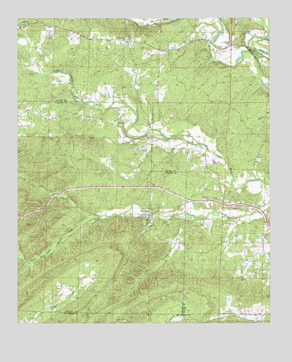
Lonsdale, AR USGS Topographic Map
Click on map above to begin viewing in our Map Viewer.

This topographic map contains these locations and features:
Feature Name Type Latitude Longitude GNIS ID View Map
Cedar Grove ChurchChurchN34.6120°W92.7749°47608View Map
CrowsPopulated PlaceN34.6143°W92.7693°48236View Map
Crows Volunteer Fire DepartmentBuildingN34.6126°W92.7723°2116329View Map
Lake IsabellaReservoirN34.6247°W92.8703°2787039View Map
LonsdalePopulated PlaceN34.5445°W92.8082°51451View Map
Lonsdale Fire Department Station 1BuildingN34.5441°W92.8120°2116742View Map
Lonsdale Fire Department Station 2BuildingN34.5215°W92.7518°2116743View Map
Lonsdale Post OfficePost OfficeN34.5426°W92.8080°2781881View Map
Meaford (historical)Populated PlaceN34.5248°W92.8699°64332View Map
NancePopulated PlaceN34.5481°W92.7707°58238View Map
OwensvillePopulated PlaceN34.6159°W92.8216°53108View Map
Pleasant Run CreekStreamN34.5434°W92.7866°53602View Map
Rural Dale SchoolSchoolN34.5509°W92.7807°54276View Map
Slate Branch CemeteryCemeteryN34.6234°W92.8682°54897View Map
Smith Creek ChurchChurchN34.5823°W92.8254°54949View Map
South Tenmile CreekStreamN34.5440°W92.8332°55041View Map
Spring LakeReservoirN34.5405°W92.8098°80367View Map
Spring Lake DamDamN34.5418°W92.8085°80366View Map
Ten Mile Missionary Baptist ChurchChurchN34.5509°W92.7760°78532View Map
Town of LonsdaleCivilN34.5448°W92.8104°2406042View Map
Township of LibertyCivilN34.5494°W92.7614°69045View Map
Township of Phillips (historical)CivilN34.5473°W92.8418°66598View Map

Note: Coordinates in the location and feature list above are referenced to NAD83 datum.


Copyright (C) 2008-2025 Ryan Niemi / Sunset Dynamics ... All Rights Reserved