TopoQuest Logo
Do you find TopoQuest useful?
Help keep TopoQuest running and adding new maps/features by donating!
Bitcoin:  19c7KJd3qBynnjoSw5npx9KScwjBe4ifkT
Litecoin:  LXs6TkuXGGXo1vDsWCkWVdjQX94eUKd6ui
Home View Maps Find Maps Find Places Resources & Links


Fountain Lake, Arkansas Topographic Map

USGS Map Title: Fountain Lake, AR
USGS Map MRC: 34092E8
DRG (GeoTIFF) Download: o34092e8.tif


Neighboring USGS Topographic Map Quads:


  Jessieville, AR  
34093F1
 

  Goosepond Mountain, AR  
34092F8
 

  Lonsdale NE, AR  
34092F7
 

  Hot Springs North, AR  
34093E1
 

  Fountain Lake, AR  
34092E8
 

  Lonsdale, AR  
34092E7
 

  Hot Springs South, AR  
34093D1
 

  Lake Catherine, AR  
34092D8
 

  Malvern North, AR  
34092D7


Map MRC Location:

N35°
W93°
N35°
W92°
H8 H7 H6 H5 H4 H3 H2 H1
G8 G7 G6 G5 G4 G3 G2 G1
F8 F7 F6 F5 F4 F3 F2 F1
E8 E7 E6 E5 E4 E3 E2 E1
D8 D7 D6 D5 D4 D3 D2 D1
C8 C7 C6 C5 C4 C3 C2 C1
B8 B7 B6 B5 B4 B3 B2 B1
A8 A7 A6 A5 A4 A3 A2 A1
N34°
W93°
N34°
W92°

Fountain Lake, AR USGS 1:24K Topographic Map Preview:
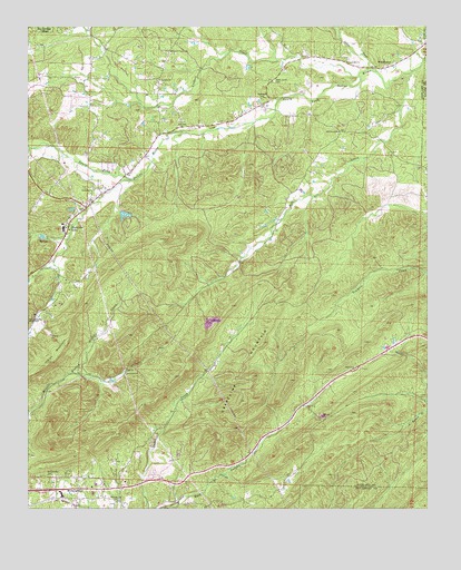
Fountain Lake, AR USGS Topographic Map
Click on map above to begin viewing in our Map Viewer.

This topographic map contains these locations and features:
Feature Name Type Latitude Longitude GNIS ID View Map
Benoit AirfieldAirportN34.5977°W92.9372°2770240View Map
Beth Jacob CemeteryCemeteryN34.6109°W92.9232°46418View Map
Cedar CreekStreamN34.6131°W92.8907°71072View Map
Center Hill ChurchChurchN34.6156°W92.9002°47635View Map
Cutter - Morning Star Elementary SchoolSchoolN34.5032°W92.9902°2039267View Map
Cutter - Morning Star High SchoolSchoolN34.5044°W92.9903°2039268View Map
Dripping Springs (historical)Populated PlaceN34.5348°W92.9818°64328View Map
Fountain LakeReservoirN34.5762°W92.9699°80359View Map
Fountain LakePopulated PlaceN34.5729°W92.9877°57768View Map
Fountain Lake DamDamN34.5768°W92.9718°80358View Map
Fountain Lake Elementary SchoolSchoolN34.5729°W92.9883°64306View Map
Fountain Lake Fire Department Station 1BuildingN34.6041°W92.9278°2116453View Map
Fountain Lake High SchoolSchoolN34.5736°W92.9896°64307View Map
Grapevine MountainRidgeN34.5365°W92.9330°49565View Map
Gulpha (historical)Populated PlaceN34.5084°W92.9391°64313View Map
High Point (historical)Populated PlaceN34.5362°W92.8955°64316View Map
Indian MountainRidgeN34.5465°W92.9871°50504View Map
Lockett CreekStreamN34.6123°W92.8963°51361View Map
McClendon CemeteryCemeteryN34.5088°W92.9940°51796View Map
Medlock CemeteryCemeteryN34.6062°W92.9268°51895View Map
Mill CreekStreamN34.6126°W92.8805°51993View Map
Mill Creek Baptist ChurchChurchN34.5979°W92.9027°77661View Map
Morning StarPopulated PlaceN34.5054°W92.9891°58213View Map
Morning Star ChurchChurchN34.5018°W92.9721°52206View Map
Morning Star Fire Department Station 1BuildingN34.5015°W92.9854°2116810View Map
Nooner LakeReservoirN34.6145°W92.9312°81044View Map
Nooner Lake DamDamN34.6151°W92.9318°81043View Map
O'Mahoney PondReservoirN34.5766°W92.9704°80363View Map
O'Mahoney Pond DamDamN34.5751°W92.9652°80362View Map
Oak Hill ChurchChurchN34.6112°W92.9591°52929View Map
Peaceful Valley ChurchChurchN34.6184°W92.9557°53249View Map
Rockdale ChurchChurchN34.5829°W92.9796°54115View Map
South Fork BridgeBridgeN34.6034°W92.9227°64353View Map
Town of Fountain LakeCivilN34.6140°W92.9197°2406514View Map
Township of WhittingtonCivilN34.5632°W92.9965°66602View Map
WhittingtonPopulated PlaceN34.6143°W92.8885°58878View Map

Note: Coordinates in the location and feature list above are referenced to NAD83 datum.


Copyright (C) 2008-2025 Ryan Niemi / Sunset Dynamics ... All Rights Reserved