TopoQuest Logo
Do you find TopoQuest useful?
Help keep TopoQuest running and adding new maps/features by donating!
Bitcoin:  19c7KJd3qBynnjoSw5npx9KScwjBe4ifkT
Litecoin:  LXs6TkuXGGXo1vDsWCkWVdjQX94eUKd6ui
Home View Maps Find Maps Find Places Resources & Links


Gourd, Arkansas Topographic Map

USGS Map Title: Gourd, AR
USGS Map MRC: 33091G5
DRG (GeoTIFF) Download: o33091g5.tif


Neighboring USGS Topographic Map Quads:


  Avery, AR  
33091H6
 

  Gould, AR  
33091H5
 

  Dumas, AR  
33091H4
 

  Tyro, AR  
33091G6
 

  Gourd, AR  
33091G5
 

  Winchester, AR  
33091G4
 

  Collins NW, AR  
33091F6
 

  Selma, AR  
33091F5
 

  McGehee North, AR  
33091F4


Map MRC Location:

N34°
W92°
N34°
W91°
H8 H7 H6 H5 H4 H3 H2 H1
G8 G7 G6 G5 G4 G3 G2 G1
F8 F7 F6 F5 F4 F3 F2 F1
E8 E7 E6 E5 E4 E3 E2 E1
D8 D7 D6 D5 D4 D3 D2 D1
C8 C7 C6 C5 C4 C3 C2 C1
B8 B7 B6 B5 B4 B3 B2 B1
A8 A7 A6 A5 A4 A3 A2 A1
N33°
W92°
N33°
W91°

Gourd, AR USGS 1:24K Topographic Map Preview:
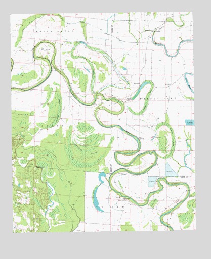
Gourd, AR USGS Topographic Map
Click on map above to begin viewing in our Map Viewer.

This topographic map contains these locations and features:
Feature Name Type Latitude Longitude GNIS ID View Map
Arrington BrakeSwampN33.8164°W91.5935°45938View Map
Bear SloughGutN33.8259°W91.5493°63772View Map
Belle Anderson Brake (historical)SwampN33.7820°W91.5137°63773View Map
Campbells BrakeSwampN33.8018°W91.5739°47355View Map
Cooks BrakeSwampN33.7719°W91.5694°47983View Map
Curtis Hall CemeteryCemeteryN33.8579°W91.5010°48275View Map
Cypress Grove CemeteryCemeteryN33.7679°W91.5473°48315View Map
Cypress Grove Church (historical)ChurchN33.7676°W91.5473°63887View Map
Eastman BrakeSwampN33.8114°W91.5205°48785View Map
Eureka School (historical)SchoolN33.8170°W91.5451°63775View Map
Fletcher BrakeSwampN33.8333°W91.5586°49128View Map
GourdPopulated PlaceN33.8437°W91.5968°77046View Map
Grissoms BendBendN33.7746°W91.5051°79016View Map
Jerusalem ChurchChurchN33.8418°W91.5971°64063View Map
Mills SloughGutN33.8693°W91.5804°52082View Map
Morning Star Baptist ChurchChurchN33.7698°W91.5043°77690View Map
Mount Pisner Church (historical)ChurchN33.7723°W91.5573°63888View Map
New Bethel ChurchChurchN33.8337°W91.5373°52622View Map
Orange ChapelChurchN33.8645°W91.5273°53067View Map
Palestine ChurchChurchN33.8318°W91.6104°53135View Map
Raddish BendBendN33.7884°W91.5273°63776View Map
Saint Pauls ChurchChurchN33.8334°W91.5160°54455View Map
Serene ChurchChurchN33.8029°W91.5385°54672View Map
Slide Off BendBendN33.7893°W91.5523°63779View Map
Taylor CemeteryCemeteryN33.7693°W91.5512°55460View Map
The GourdBendN33.8543°W91.6021°55511View Map
Township of Walnut LakeCivilN33.8251°W91.5033°66507View Map
Valley BrakeSwampN33.7663°W91.5285°55870View Map
Valley FarmLocaleN33.7684°W91.5487°78642View Map
Walnut Grove Church (historical)ChurchN33.7940°W91.5260°63780View Map
Wilborn BrakeSwampN33.8245°W91.5324°56346View Map

Note: Coordinates in the location and feature list above are referenced to NAD83 datum.


Copyright (C) 2008-2025 Ryan Niemi / Sunset Dynamics ... All Rights Reserved